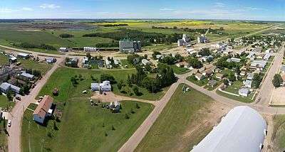
Canwood
| Canwood | |
|---|---|
| Village | |
| Village of Canwood | |
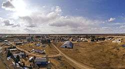 Aerial image of Canwood looking towards the west | |
 Canwood Location of Canwood in Saskatchewan | |
| Coordinates: 53°22′N 106°36′W / 53.36°N 106.6°WCoordinates: 53°22′N 106°36′W / 53.36°N 106.6°W[1] | |
| Country |
|
| Province |
|
| Census division | 16 |
| Rural Municipality | Canwood No. 494 |
| Post office Founded | September 1, 1911 |
| Government | |
| • Type | Municipal |
| • Canwood Village Council | Robert Thompson (Governing body) |
| • Mayor | Robert Thompson |
| • Administrator | Erin Robertson |
| • MLA | Scott Moe - Rosthern-Shellbrook |
| • MP | Rob Clarke - Desnethé—Missinippi—Churchill River |
| Area | |
| • Total | 2.56 km2 (0.99 sq mi) |
| • Land | 129.6 km2 (50.0 sq mi) |
| Elevation[2] | 482 m (1,581 ft) |
| Population (2016)[3] | |
| • Total | 332 |
| • Density | 130/km2 (340/sq mi) |
| Time zone | UTC−6 (CST) |
| Postal Code | S0J 0K0 |
| Area code(s) | 306 |
| Highways |
|
| Website |
www |
| [4][5] | |
Canwood is a village within the Rural Municipality of Canwood No. 494, Saskatchewan, Canada. As of the 2016 Census, the village had a population of 332,[6] with a larger rural municipality (Canwood No. 494) population of 1,381.[7]
Demographics
| Canada census – Canwood community profile | |||
|---|---|---|---|
| 2016 | 2011 | ||
| Population: | 332 (-4.6% from 2011) | 308 (-8.6% from 2006) | |
| Land area: | 2.56 km2 (0.99 sq mi) | 2.56 km2 (0.99 sq mi) | |
| Population density: | 129.6/km2 (336/sq mi) | 120.2/km2 (311/sq mi) | |
| Median age: | 60.2 (M: 59.3, F: 61.6) | 56.8 (M: 55.1, F: 58.5) | |
| Total private dwellings: | 176 | 177 | |
| Median household income: | |||
| References: 2016[8] 2011[9] earlier[10] | |||
History
Since it was settled, Canwood has gone through four name changes.[11] Records kept by the post office show the original name of the settlement was "Parksiding," but no evidence has shown it ever operated under that name. The post office opened September 1, 1911, operating under the town name "McQuan"; this was a typographical error, and three months later the name was corrected to "McOwan." This name honoured Alexander McOwan, a pioneer settler who was an immigration agent, estate manager, and author. On June 1, 1912, the town name was changed again to "Forgaard," honouring Jens Forgaard, a Norwegian-born settler who had emigrated from Minnesota. Exactly one year later, on June 1, 1913, the name was changed for the last time to "Canwood," a portmanteau of Canadian Woodlands. This name is rumored to be proposed by a man named Edward Charles Bowman.
It is also said that Edward Charles Bowman and Minnie (Swedlund) Bowman started a Sunday school in Canwood in 1914, now known as Canwood Pentecostal Church. Edward became the Sunday School superintendent, Minnie the teacher, and son Ray the organist. The family also donated a piece of land on the south quarter as a burying ground—it is now known as the Canwood North Cemetery. Edward, a linguist (Swedish, Danish, Norwegian, English, and German) would also write important letters for some of the settlers with language difficulties.
Education
Canwood Community School is the only educational institution in Canwood.[12] Part of the Saskatchewan Rivers School Division #119, it educates students from Kindergarten to Grade 12. Higher education can be pursued out of town at the Saskatchewan Institute of Applied Science and Technology, University of Saskatchewan, or University of Regina.
Surrounding Area
Canwood is located along Highway 55, and neighbours the towns of Debden and Shellbrook.
The Canwood Regional Park is located 5 kilometres (3 mi) southeast from Canwood along Highway 55. It has 20 campsites, a 9-hole golf course, and three baseball diamonds, and is open May through September.[13]
Urban legend
An urban legend says Albert Einstein played goal for the Canwood Canucks one winter while traveling to find peace and silence for his work on the Theory of Relativity.[14] This story has been found to be implausible by media observers;[15] in addition to the unlikeliness of Einstein visiting the rural community of Canwood, the Canwood Canucks hockey team was formed in 1958,[16] three years after his death.
See also
References
- ↑ "Co-ordinates". Google Maps. Retrieved February 22, 2012.
- ↑ "Canwood, Saskatchewan". RoadsideThoughts. Retrieved February 21, 2012.
- ↑ "Canwood, Village". Census Profile. Statistics Canada 2011. Retrieved February 21, 2012.
- ↑ "Post Offices and Postmasters". Library and Archives Canada. Government of Canada. Archived from the original on October 6, 2006. Retrieved February 26, 2014.
- ↑ "Municipal Directory System". Government of Saskatchewan. Archived from the original on January 15, 2016. Retrieved February 26, 2014.
- ↑ "Statistics Canada Canwood 2016 Community Profile". Retrieved February 20, 2017.
- ↑ "Statistics Canada Canwood No.494 2016 Community Profile". Retrieved February 20, 2017.
- ↑ "2016 Community Profiles". Canada 2016 Census. Statistics Canada. February 21, 2017. Retrieved 2017-03-15.
- ↑ "2011 Community Profiles". Canada 2011 Census. Statistics Canada. July 5, 2013. Retrieved February 27, 2015.
- ↑ "2001 Community Profiles". Canada 2001 Census. Statistics Canada. February 17, 2012.
- ↑ Barry, Bill (1997). People Places: Saskatchewan and its names. Regina: Printwest. p. 58. ISBN 0-88977-114-6.
- ↑ "Canwood Community School Homepage". Retrieved November 11, 2011.
- ↑ "The Canwood Regional Park". Village of Canwood. Retrieved April 27, 2014.
- ↑ "Club Sask: I bet you didn't know..." Retrieved November 11, 2011.
- ↑ "Separating rural myths from reality". Regina Leader Post. April 21, 2008. Retrieved November 11, 2011.
- ↑ Friesen (1981). Chronicles of Canwood and Districts. Canwood History Book Committee. p. 382. ISBN 0-88925-164-9.
External links
- Village of Canwood - Official website
| Subdivisions | |
|---|---|
| Communities | |
| Cities | |
| Topics |
|
| |
| Cities | 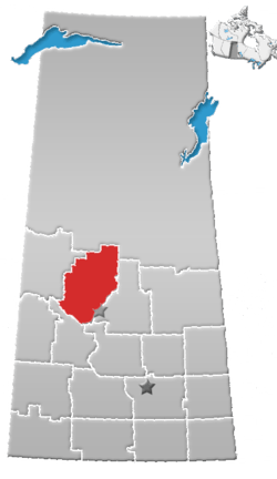 | |
|---|---|---|
| Towns | ||
| Villages | ||
| Resort villages | ||
| Rural municipalities | ||
| Indian reserves |
| |
| Unincorporated communities | ||