Denholm, Saskatchewan
| Denholm | |
|---|---|
| Village | |
| Village of Denholm | |
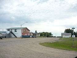 Main Street Denholm | |
 Location of Denholm in Saskatchewan  Denholm, Saskatchewan (Canada) | |
| Coordinates: 52°39′25″N 108°00′40″W / 52.657°N 108.011°W | |
| Country |
|
| Province |
|
| Region | Central |
| Census division | 16 |
| Rural Municipality | Mayfield No. 406 |
| Government | |
| • Type | Municipal |
| • Governing body | Denholm Village Council |
| • Mayor | Donna Oborowsky |
| • Administrator | Lila Yuhasz |
| Area | |
| • Total | 0.33 km2 (0.13 sq mi) |
| Population (2016) | |
| • Total | 88 |
| • Density | 269.6/km2 (698/sq mi) |
| Time zone | UTC-6 (CST) |
| Postal code | S0M 0R0 |
| Area code(s) | 306 |
| Highways |
|
| [1][2][3][4] | |
Denholm is a village within the Rural Municipality of Mayfield No. 406, Saskatchewan, Canada. The village had a population of 88 in the 2016 Census, (a 15.8% increase from 76 in the 2011 Census).
Demographics
| Canada census – Denholm, Saskatchewan community profile | |||
|---|---|---|---|
| 2016 | 2011 | 2006 | |
| Population: | 88 (+15.8% from 2011) | 76 (+24.6% from 2006) | 61 (-22.8% from 2001) |
| Land area: | 0.33 km2 (0.13 sq mi) | 0.33 km2 (0.13 sq mi) | 186.9 km2 (72.2 sq mi) |
| Population density: | 269.6/km2 (698/sq mi) | 232.8/km2 (603/sq mi) | 81.3/km2 (211/sq mi) |
| Median age: | 39.5 (M: 36.5, F: 42.9) | 27.5 (M: 39.2, F: 36.0) | 31.8 (M: 43.0, F: 29.5) |
| Total private dwellings: | 29 | 32 | |
| Median household income: | |||
| References: 2016[5] 2011[6] 2006[7] earlier[8] | |||
See also
References
- ↑ National Archives, Archivia Net, Post Offices and Postmasters
- ↑ Government of Saskatchewan, MRD Home, Municipal Directory System, archived from the original (– Scholar search) on November 21, 2008
- ↑ Canadian Textiles Institute. (2005), CTI Determine your provincial constituency, archived from the original on 2007-09-11
- ↑ Commissioner of Canada Elections, Chief Electoral Officer of Canada (2005), Elections Canada On-line, archived from the original on 2007-04-21
- ↑ "2016 Community Profiles". Canada 2016 Census. Statistics Canada. February 21, 2017. Retrieved 2017-03-15.
- ↑ "2011 Community Profiles". Canada 2011 Census. Statistics Canada. July 5, 2013. Retrieved 2012-10-14.
- ↑ "2006 Community Profiles". Canada 2006 Census. Statistics Canada. March 30, 2011. Retrieved 2009-02-24.
- ↑ "2001 Community Profiles". Canada 2001 Census. Statistics Canada. February 17, 2012.
External links
- Saskatchewan City & Town Maps
- Saskatchewan Gen Web - One Room School Project
- Post Offices and Postmasters - ArchiviaNet - Library and Archives Canada
- Saskatchewan Gen Web Region
- Online Historical Map Digitization Project
- GeoNames Query
- 2006 Community Profiles
Places adjacent to Denholm, Saskatchewan | ||||||||||
|---|---|---|---|---|---|---|---|---|---|---|
| ||||||||||
| Subdivisions | |
|---|---|
| Communities | |
| Cities | |
| Topics |
|
| |
| Cities | 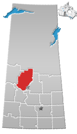 | |
|---|---|---|
| Towns | ||
| Villages | ||
| Resort villages | ||
| Rural municipalities | ||
| Indian reserves |
| |
| Unincorporated communities | ||
Coordinates: 52°39′25″N 108°00′40″W / 52.657°N 108.011°W
This article is issued from
Wikipedia.
The text is licensed under Creative Commons - Attribution - Sharealike.
Additional terms may apply for the media files.