Campeche City
| San Francisco de Campeche | ||
|---|---|---|
| City | ||
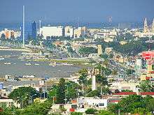
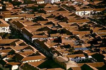
   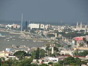  Photomontage of Campeche City | ||
| ||
 Location of Campeche within the state | ||
 Location of the state within Mexico | ||
| Coordinates: 19°51′0″N 90°31′50″W / 19.85000°N 90.53056°WCoordinates: 19°51′0″N 90°31′50″W / 19.85000°N 90.53056°W | ||
| Country | Mexico | |
| State | Campeche | |
| Municipality | Campeche | |
| City Founded | October 4, 1540 (478 years ago) | |
| Government | ||
| • Mayor | Eliseo Fernández Montúfar (2018–2021) | |
| Elevation | 10 m (33 ft) | |
| Population (2010) | ||
| • Total | 220,389 | |
| Demonym(s) | Campechano | |
| Time zone | UTC−6 (Central (US Central)) | |
| • Summer (DST) | UTC−5 (Central) | |
| Area code(s) | 981 | |
| Major Airport | Ing. Alberto Acuña Ongay International Airport | |
| IATA Code | CPE | |
| ICAO Code | MMCP | |
| Website | Official Campeche Website | |
| Official name | Historic Fortified Town of Campeche | |
| Type | Cultural | |
| Criteria | ii, iv | |
| Designated | 1999 (23rd session) | |
| Reference no. | 895 | |
| State Party |
| |
| Region | Latin America and the Caribbean | |

San Francisco de Campeche[1] (pronounced [saɱ fɾanˈsisko ðe kamˈpe.tʃe]; Yucatec Maya: Ahk'ìin Pech, pronounced [aχkʼiːn˥˧ pʰetʃ]), 19th c. English also Campeachy,[2] is a city in Campeche Municipality in the state of Campeche, Mexico—located at 19°51′N 90°32′W / 19.85°N 90.53°W, on the shore of the Bay of Campeche of the Gulf of Mexico—and its municipal seat also serves as the state's capital city. The city's population at the 2010 census was 220,389,[3] and the municipality for which it serves as municipal seat had a population of 259,005.[3]
The city was founded in 1540 by Spanish conquistadores as San Francisco de Campeche atop the pre-existing Maya city of Can Pech. The Pre-Columbian city was described as having 3,000 houses and various monuments, of which little trace remains.
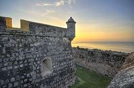
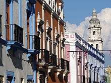
The city retains many of the old colonial Spanish city walls and fortifications which protected the city (not always successfully) from pirates and buccaneers. The state of preservation and quality of its architecture earned it the status of a UNESCO World Heritage Site in 1999. Originally, the Spaniards lived inside the walled city, while the natives lived in the surrounding barrios of San Francisco, Guadalupe and San Román. These barrios still retain their original churches; the one in Guadalupe is almost 500 years old.
History
Founded in 1540 by Francisco Montejo, Campeche was terrorized by pirates and marauders until the city started fortification in 1686.[4]
San Francisco de Campeche was originally an indigenous village, Ah Kim Pech, where the Spanish first landed in Mexico in 1517. The city of Campeche was founded in 1540 and fortified against pirates during the 17th century. It still has the appearance of a fortress. Historical monuments and buildings, such as the Franciscan cathedral, old Maya ruins, and the old city walls and forts, attract many tourists.
The fortifications system of Campeche, an eminent example of the military architecture of the 17th and 18th centuries, is part of an overall defensive system set up by the Spanish to protect the ports on the Caribbean Sea from pirate attacks like the 1663 Sack of Campeche.
The state of preservation and quality of its architecture earned it the status of a World Heritage Site in 1999.[5][6]
City fortifications

The city of Campeche is an example of urbanism in a baroque colonial city, with a reticular and regular plan, its urban trace, a model of colonial port cities, reflects the main role that it played as a commercial, religious and military connection point characterized by its high level of integrity and homogeneity. More than one thousand buildings with a historic value have survived as witnesses of space and temporal superimposition of several significant historic periods of Mexico.
Due to the constant attacks of both English and Dutch buccaneers and pirates such as Francis Drake, John Hawkins, Laurens de Graaf, Cornelis Jol, Jacobo Jackson, Jean Lafitte, Francisco de Grammont, Bartolomé Portugués, William Parker, Francisco Nau, Edward Mansvelt, Henry Morgan, Lewis Scot, Roche Braziliano and Michel de Grammont for almost 160 years, in 1686 the government started to fortify the city.[4]
The French engineer Louis Bouchard de Becour was commissioned to unify all the defensive works that surrounded the city with a wall. At its completion, the wall surrounding the city of Campeche was 2,560 meters in length, forming an irregular hexagon around the main part of the city, with eight defensive bastions on the corners. These bulwarks now serve different functions:
- Santiago: Used as the Botanical Garden 'Xmuch´haltún'. Reconstructed.
- San Pedro: Former prison.
- San Francisco: Protects the Land Gate. Houses the library of the INAH.
- San Juan: Protects the Land Gate.
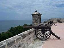
- Nuestra Señora de la Soledad: Also protects the Sea Gate. It is the largest one and holds the Museum of City History.
- San Carlos: Holds the City Museum. This fort was the first one built. Protects the Sea Gate.
- Santa Rosa.
It also contained four gates to allow access to the main quarters. The main entrances are the Puerta de la tierra ("Land Gate"), built in 1732, and the Puerta del mar ("Sea Gate"). The Land Gate is kept as a tourist attraction, having a light and sound show three nights each week and keeping original supplies and items from the 17th century. The other gates were Guadalupe and San Román, connecting to the outside neighborhoods.
Additionally, two main forts protected the city from two nearby hills on each side, the forts of San José el Alto (built in 1762) and San Miguel. These forts gave long-range artillery coverage and served also as look-outs. They were built before the walls of the city. The fort of San Miguel is used as a museum and houses a collection of pre-Hispanic items. The fort of San José houses a collection of boats and weapons of the period.
Demographics

As of 2010, the municipality had a total population of 259,005.[3]
The municipal seat, and largest settlement, is the city of San Francisco de Campeche (often shortened to Campeche). As of 2010, the city had a population of 220,389.[3]
Aside from the municipal seat, the municipality has 564 localities.
The largest localities are, (with 2010 populations in parentheses): Lerma (8,281), Chiná (5,194), classified as urban, and Los Laureles (2,251), Alfredo V. Bonfil (2,060), Pich (1,756), Tikinmul (1,663), Imí (1,227), Hampolol (1,123), Castamay (1,101), and San Francisco Kobén (1,045), classified as rural.[3]
Sister cities


Climate
Campeche has a tropical savanna climate, with most rain falling in the wet season from June to October.
| Climate data for Campeche (1951–2010) | |||||||||||||
|---|---|---|---|---|---|---|---|---|---|---|---|---|---|
| Month | Jan | Feb | Mar | Apr | May | Jun | Jul | Aug | Sep | Oct | Nov | Dec | Year |
| Record high °C (°F) | 38.8 (101.8) |
39.0 (102.2) |
41.0 (105.8) |
44.0 (111.2) |
45.0 (113) |
43.0 (109.4) |
40.0 (104) |
40.0 (104) |
39.0 (102.2) |
40.5 (104.9) |
38.0 (100.4) |
40.0 (104) |
45.0 (113) |
| Average high °C (°F) | 29.1 (84.4) |
30.6 (87.1) |
32.7 (90.9) |
35.0 (95) |
35.9 (96.6) |
34.9 (94.8) |
34.5 (94.1) |
34.2 (93.6) |
33.4 (92.1) |
32.1 (89.8) |
30.7 (87.3) |
29.4 (84.9) |
32.7 (90.9) |
| Daily mean °C (°F) | 23.7 (74.7) |
24.7 (76.5) |
26.5 (79.7) |
28.5 (83.3) |
29.6 (85.3) |
29.2 (84.6) |
28.7 (83.7) |
28.5 (83.3) |
28.2 (82.8) |
27.0 (80.6) |
25.4 (77.7) |
24.0 (75.2) |
27.0 (80.6) |
| Average low °C (°F) | 18.2 (64.8) |
18.7 (65.7) |
20.2 (68.4) |
22.1 (71.8) |
23.4 (74.1) |
23.5 (74.3) |
22.9 (73.2) |
22.7 (72.9) |
22.9 (73.2) |
21.9 (71.4) |
20.0 (68) |
18.6 (65.5) |
21.3 (70.3) |
| Record low °C (°F) | 8.0 (46.4) |
9.0 (48.2) |
10.0 (50) |
13.0 (55.4) |
16.0 (60.8) |
17.0 (62.6) |
18.0 (64.4) |
19.0 (66.2) |
18.0 (64.4) |
15.0 (59) |
12.0 (53.6) |
9.0 (48.2) |
8.0 (46.4) |
| Average precipitation mm (inches) | 25.8 (1.016) |
15.8 (0.622) |
12.4 (0.488) |
13.0 (0.512) |
53.9 (2.122) |
162.0 (6.378) |
181.3 (7.138) |
188.2 (7.409) |
203.1 (7.996) |
117.9 (4.642) |
41.0 (1.614) |
25.0 (0.984) |
1,039.4 (40.921) |
| Average precipitation days (≥ 0.1 mm) | 3.9 | 2.5 | 2.0 | 1.3 | 3.9 | 11.7 | 14.8 | 14.6 | 14.3 | 9.3 | 4.7 | 3.5 | 86.5 |
| Average relative humidity (%) | 74 | 71 | 68 | 66 | 64 | 68 | 74 | 76 | 78 | 77 | 77 | 75 | 72 |
| Mean monthly sunshine hours | 216 | 200 | 264 | 267 | 254 | 237 | 241 | 236 | 202 | 208 | 194 | 177 | 2,696 |
| Source #1: Servicio Meteorológico National (humidity 1981–2000)[12][13] | |||||||||||||
| Source #2: Deutscher Wetterdienst (sun, 1961–1990)[14][lower-alpha 1] | |||||||||||||
Gallery
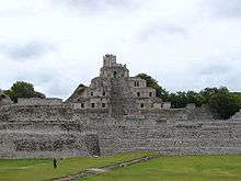 Archaeological zone of Edzná.
 Colonial Spanish houses in Campeche.
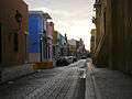 Buildings along a street in central Campeche with typical colors
 Campeche fishermen cutting up the catch on the Gulf of Mexico
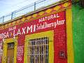 Shop in central Campeche selling magical adjuncts and elixirs
 Francisco de Paula Toro Theatre, (1832 - 1834).
 Maya stela at the Fort of San Miguel Museum.
 Cathedral of the city.
 Jardín Botánico Xmuch' Haltun
 City of Campeche
Notes
- Link to tables of population data from Census of 2005 INEGI: Instituto Nacional de Estadística, Geografía e Informática
Notes
- ↑ Station ID for Campeche, CAMP. is 76695 Use this station ID to locate the sunshine duration
References
- ↑ "Constitucion Politica del Estado de Campeche (chapter 10, article 24)" (PDF). Archived from the original (PDF) on July 25, 2011. Retrieved August 24, 2010.
- ↑ https://www.google.com/search?q=campeachy&source=lnms&tbm=bks
- 1 2 3 4 5 "Campeche". Catálogo de Localidades. Secretaría de Desarrollo Social (SEDESOL). Retrieved 23 April 2014.
- 1 2 Marley, David (2005) Historic cities of the Americas: an illustrated encyclopedia, Volume 1 p.223. ABC-CLIO, 2005
- ↑ Centre, UNESCO World Heritage. "Historic Fortified Town of Campeche". whc.unesco.org.
- ↑ World Heritage Site - Campeche Archived 2010-08-21 at the Wayback Machine.
- ↑ "Archived copy" (PDF). Archived from the original (PDF) on 2008-09-10. Retrieved 2008-09-10.
- ↑ "Sister Cities". www.ci.laredo.tx.us.
- 1 2 "Secretaría de Relaciones Exteriores - Gobierno - gob.mx". www.sre.gob.mx.
- ↑ El Municipio y Ciudad de Veracruz, Veracruz: Ciudades hermanadas. Archived 2012-07-31 at the Wayback Machine.
- ↑ "Engineering Timelines - Copenhagen key facts". www.engineering-timelines.com.
- ↑ "Estado de Campeche–Estacion: Campeche (DGE)". NORMALES CLIMATOLÓGICAS 1951–2010 (in Spanish). Servicio Meteorológico National. Archived from the original on 18 May 2015. Retrieved 7 May 2015.
- ↑ "NORMALES CLIMATOLÓGICAS 1981–2000" (PDF) (in Spanish). Servicio Meteorológico Nacional. Archived from the original (PDF) on 25 April 2015. Retrieved 7 May 2015.
- ↑ "Station 76695 Campeche, CAMP". Global station data 1961–1990—Sunshine Duration. Deutscher Wetterdienst. Retrieved 7 May 2015.
Bibliography
External links
| Wikisource has the text of the 1911 Encyclopædia Britannica article Campeche (city). |


- Official Campeche website
Campeche (capital) | ||
| Municipalities and (municipal seats) |  | |
| Biggest Historic Centers |
|  |
|---|---|---|
| Spanish Missions concentrations |
| |
| Cathedrals | ||
| Churches and monasteries | ||
| Fortifications | ||
| Bridges and roads | ||
| Other buildings types | ||
| Architecture types | ||
| Modern Revival styles | ||
1It occurred when it was part of the Spanish kingdom Category | ||

| Authority control |
|---|