Coxsackie, New York
| Coxsackie, New York | |
|---|---|
| Town | |
 Location in Greene County and the state of New York. | |
.svg.png) Location of New York in the United States | |
| Coordinates: 42°21′27″N 73°48′29″W / 42.35750°N 73.80806°WCoordinates: 42°21′27″N 73°48′29″W / 42.35750°N 73.80806°W | |
| Country | United States |
| State | New York |
| County | Greene |
| Government | |
| • Town Supervisor | Richard K. Hanse |
| • Town Council | |
| Area[1] | |
| • Total | 38.42 sq mi (99.51 km2) |
| • Land | 36.87 sq mi (95.50 km2) |
| • Water | 1.55 sq mi (4.01 km2) |
| Population (2010) | |
| • Total | 8,918 |
| • Estimate (2016)[2] | 8,498 |
| • Density | 230.47/sq mi (88.99/km2) |
| Time zone | UTC-5 (EST) |
| • Summer (DST) | UTC-4 (EDT) |
| ZIP code | 12051 |
| Area code(s) | 518 |
| FIPS code | 36-039-18729 |
Coxsackie (/kʊkˈsæki/ kuuk-SAK-ee) is a town in Greene County, New York, United States. The population was 8,918 at the 2010 census.[3] The name of the town is said to be derived from a Native American term, but it has various translations ("owl's hoot" is locally common).
Within the area governed as a town, there is also a village called Coxsackie. The town is in the northeast part of the county.
The town of Coxsackie is notable for being the namesake of the Coxsackievirus, which was first isolated in this town.
History
The settlement of Coxsackie began in the seventeenth century, approximately 1652, as part of the development of New Netherland. The government of the area became established as a district in 1772, and Coxsackie was founded in 1788 with a town form of government. Part of Coxsackie was lost when the town of Durham was formed in 1790. Further land was lost in the formation of the newer towns of Cairo and Greenville (1803), New Baltimore (1811), and Athens (1815).
One of the first settlers in Coxsackie was Pieter Bronck, of the same family for which the Bronx is named. In 1663, he built the Pieter Bronck House in West Coxsackie, which is open as a museum. The nearby family burial ground includes a separate plot with marked graves for slaves of the family.
In 1900, the combined population of the town and village was 2,994.
Geography
According to the United States Census Bureau, the town has a total area of 38.4 square miles (99.4 km²), of which 36.9 square miles (95.6 km²) is land and 1.5 square miles (3.8 km², or 3.86%) is water.
The eastern town line is defined by the Hudson River and is the border of Columbia County.
The New York State Thruway (Interstate 87) and U.S. Route 9W pass through the town.
Demographics
| Historical population | |||
|---|---|---|---|
| Census | Pop. | %± | |
| 1820 | 2,355 | — | |
| 1830 | 3,373 | 43.2% | |
| 1840 | 3,539 | 4.9% | |
| 1850 | 3,741 | 5.7% | |
| 1860 | 3,661 | −2.1% | |
| 1870 | 3,829 | 4.6% | |
| 1880 | 4,009 | 4.7% | |
| 1890 | 3,773 | −5.9% | |
| 1900 | 4,102 | 8.7% | |
| 1910 | 3,620 | −11.8% | |
| 1920 | 2,994 | −17.3% | |
| 1930 | 3,139 | 4.8% | |
| 1940 | 4,146 | 32.1% | |
| 1950 | 4,703 | 13.4% | |
| 1960 | 4,794 | 1.9% | |
| 1970 | 4,236 | −11.6% | |
| 1980 | 6,018 | 42.1% | |
| 1990 | 7,633 | 26.8% | |
| 2000 | 8,884 | 16.4% | |
| 2010 | 8,918 | 0.4% | |
| Est. 2016 | 8,498 | [2] | −4.7% |
| U.S. Decennial Census[4] | |||
As of the census[5] of 2000, there were 8,918 people, 2,422 households, and 1,583 families residing in the town. The population density was 240.8 people per square mile (93.0/km²). There were 2,789 housing units at an average density of 75.6 per square mile (29.2/km²). The racial makeup of the town was 92.24% White, 5.33% Black or African American, 0.30% Native American, 0.61% Asian, 0.02% Pacific Islander, 0.85% from other races, and 0.64% from two or more races. Hispanic or Latino of any race were 11.15% of the population.
There were 2,422 households out of which 31.3% had children under the age of 18 living with them, 49.9% were married couples living together, 10.6% had a female householder with no husband present, and 34.6% were non-families. 28.0% of all households were made up of individuals and 11.8% had someone living alone who was 65 years of age or older. The average household size was 2.46 and the average family size was 3.01.
In the town, the population was spread out with 18.7% under the age of 18, 24.3% from 18 to 24, 29.9% from 25 to 44, 18.3% from 45 to 64, and 8.8% who were 65 years of age or older. The median age was 30 years. For every 100 females, there were 185.9 males. For every 100 females age 18 and over, there were 210.9 males.
The median income for a household in the town was $37,830, and the median income for a family was $46,189. Males had a median income of $37,823 versus $26,859 for females. The per capita income for the town was $16,830. About 9.5% of families and 12.9% of the population were below the poverty line, including 15.7% of those under age 18 and 16.2% of those age 65 or over.
Communities and locations in the town of Coxsackie
- Bronck House – A house in West Coxsackie built by Pieter Bronck in 1663 (open as a museum)
- Climax – A hamlet northwest of Coxsackie village on Route 81
- Coxsackie – The village of Coxsackie
- Coxsackie Correctional Facility – A state prison southwest of Coxsackie village
- Earlton – A hamlet in the western part of the town. The Forestville Commonwealth Owenite community at Earlton was listed on the National Register of Historic Places in 1974.[6]
- Hudson Islands State Park
- Surprise – A hamlet at the west town line
- Sleepy Hollow Lake – A lake partly in the south part of the town (a "resort" development)
- West Coxsackie – A hamlet northwest of Coxsackie village on Route 81
- Greene Correctional Facility -a state prison adjacent to Coxsackie Correctional Facility
References
- ↑ "2016 U.S. Gazetteer Files". United States Census Bureau. Retrieved Jul 5, 2017.
- 1 2 "Population and Housing Unit Estimates". Retrieved June 9, 2017.
- ↑ "Geographic Identifiers: 2010 Demographic Profile Data (G001): Coxsackie town, Greene County, New York". American Factfinder. U.S. Census Bureau. Retrieved December 29, 2016.
- ↑ "Census of Population and Housing". Census.gov. Archived from the original on May 12, 2015. Retrieved June 4, 2015.
- ↑ "American FactFinder". United States Census Bureau. Archived from the original on September 11, 2013. Retrieved 2008-01-31.
- ↑ National Park Service (2009-03-13). "National Register Information System". National Register of Historic Places. National Park Service.
External links
- Town of Coxsackie official website
- Coxsackie Town Court
- Heermance Memorial Library (Coxsackie)
- Village of Coxsackie
Municipalities and communities of Greene County, New York, United States | ||
|---|---|---|
| Towns | 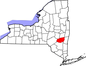 | |
| Villages | ||
| CDPs | ||
| Other hamlets | ||