Cadell, South Australia
| Cadell South Australia | |||||||||||||||
|---|---|---|---|---|---|---|---|---|---|---|---|---|---|---|---|
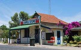 Store and post office | |||||||||||||||
 Cadell | |||||||||||||||
| Coordinates | 34°02′24″S 139°45′40″E / 34.039911°S 139.761038°ECoordinates: 34°02′24″S 139°45′40″E / 34.039911°S 139.761038°E[1] | ||||||||||||||
| Population | 548 (2016 census)[2] | ||||||||||||||
| Established |
29 July 1920 (town) 27 March 2003 (locality)[1][3] | ||||||||||||||
| Location | 192 km (119 mi) from Adelaide | ||||||||||||||
| LGA(s) | Mid Murray Council[1] | ||||||||||||||
| County | Albert[1] | ||||||||||||||
| State electorate(s) | Chaffey[4] | ||||||||||||||
| Federal Division(s) | Barker[5] | ||||||||||||||
| |||||||||||||||
| Footnotes | Adjoining localities[1] | ||||||||||||||
Cadell is a town and locality situated near the north western edge of South Australia's Riverland on the inside of the large southward bend in the Murray River. It is named after Captain Francis Cadell, a pioneer of steam-powered navigation on the Murray River.[6] The town of Cadell was surveyed in 1919 and named in 1920. It is slightly upstream of the earlier failed village settlement of New Era, however what is now the Cadell Irrigation Area is the same as was previously the New Era irrigation area.[7]
Land Use
Cadell is a quiet rural township in the middle of a citrus and wine grape growing area. Most of the major services (medical, pharmacy, shopping, police, mechanical, etc.) are provided at nearby Waikerie. Limited services are also available at Morgan. Crossing of the Murray River is provided by a free government ferry service. It is also home to a low security prison for men, the Cadell Training Centre.[6][8][9]
Part of the Hogwash Bend Conservation Park is located at the locality's eastern end.[10]
See also
References
| Wikimedia Commons has media related to Cadell, South Australia. |
- 1 2 3 4 5 "Search result for Cadell, LOCB' with the following datasets selected - 'Local Government areas', 'SA Government Regions', 'Counties', 'Postcode', 'Suburbs and Localities', 'Land Development Plan Zone Categories', 'Roads', 'Government Towns' and 'Gazetteer'". Retrieved 2 April 2018.
- ↑ Australian Bureau of Statistics (27 June 2017). "Cadell". 2016 Census QuickStats. Retrieved 2 April 2018.

- ↑ WEATHERILL, J. (27 March 2003). "GEOGRAPHICAL NAMES ACT 1991 Notice to Assign Names and Boundaries to Places (in the Mid Murray Council)" (PDF). the South Australian Government Gazette. South Australian Government. p. 1184. Retrieved 2 April 2018.
- ↑ "Electoral district of Chaffey". Electoral Commission SA. Retrieved 27 March 2018.
- ↑ "Electoral division of Barker" (PDF). Australian Electoral Commission. Retrieved 27 March 2018.
- 1 2 "Cadell, South Australia". Travelmate.com.au. Retrieved 2006-09-08.
- ↑ "Placename Details: Cadell Irrigation Area". Property Location Browser. Department of Planning, Transport and Infrastructure. 28 July 2008. SA0011495. Archived from the original on 12 October 2016. Retrieved 29 January 2015.
- ↑ "Correctional facilities in South Australia: Cadell Training Centre". Australian Institute of Criminology. 11 March 2005. Archived from the original on 6 May 2006. Retrieved 2006-09-08.
- ↑ "Cadell Training Centre". Prison & Prisoner Management. Department of Justice Correctional Services and South Australian Government. 1997–1998. Retrieved 2006-09-08.
- ↑ "Search results for 'Hogwash Bend Conservation Park' with the following datasets selected – 'Suburbs and Localities', 'Government Towns', 'NPW and Conservation Boundaries', 'NPW and Conservation Properties', 'Roads' and 'Gazetteer'". Location SA Map Viewer. South Australian Government. Retrieved 12 April 2018.