Palmer, South Australia
| Palmer South Australia | |||||||||||||||
|---|---|---|---|---|---|---|---|---|---|---|---|---|---|---|---|
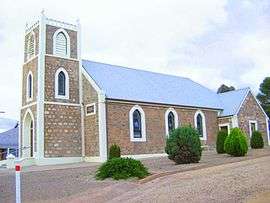 Palmer Lutheran Church | |||||||||||||||
 Palmer | |||||||||||||||
| Coordinates | 34°51′07″S 139°09′36″E / 34.852°S 139.160°ECoordinates: 34°51′07″S 139°09′36″E / 34.852°S 139.160°E | ||||||||||||||
| Population | 329 (2006 census)[1] | ||||||||||||||
| Established | 1860s | ||||||||||||||
| Postcode(s) | 5237 | ||||||||||||||
| LGA(s) | Mid Murray Council | ||||||||||||||
| State electorate(s) | Schubert | ||||||||||||||
| Federal Division(s) | Barker | ||||||||||||||
| |||||||||||||||
| Footnotes | [2] | ||||||||||||||
Palmer is a town just east of the Adelaide Hills region of South Australia along the Adelaide-Mannum Road, 70 kilometres east-north-east of the state capital, Adelaide and 15 km west-north-west of Mannum (34°51′S 139°9′E / 34.850°S 139.150°E). It is located in the Mid Murray Council local government area. At the 2006 census, Palmer had a population of 329.[1]
Palmer is sited on the western confines of the indigenous Ngaralta people. The first European explorers through the Palmer district were Dr George Imlay and John Hill in January 1838.[3]
Earlier known as "Reedy Creek", the town was named after Colonel George Palmer, a South Australian Colonisation Commissioner.[4] It was settled in the 1860s as a mining and agricultural settlement.
At the ABS 2001 census, Palmer had a population of 305 people living in 124 dwellings.
Palmer has a primary school, a general store, hotel[5] and a Lutheran Church[6] of which Carl Heinrich Loessel was the first pastor, from 22 May 1869 before the church was built, succeeded by the long-serving Pastor Kuss.[7]
There are some nearby rock formations.
Heritage listings
Palmer has a number of heritage-listed sites, including:
References
- 1 2 Australian Bureau of Statistics (25 October 2007). "Palmer (State Suburb)". 2006 Census QuickStats. Retrieved 17 October 2011.
- ↑ "Placename Details: Palmer (LOCB)". Property Location Browser Report. Government of South Australia. 26 March 2007. SA0053022. Retrieved 17 March 2018.
- ↑ "SOUTH AUSTRALIA". The Australian. 27 March 1838. p. 3.
- ↑ Place Names of South Australia, State Library of South Australia. Accessed 9 July 2006.
- ↑ White Pages Online. Accessed 18 June 2006.
- ↑ Lutheran Church of Australia. Accessed 7 April 2007
- ↑ "St. Paul's Lutheran Church, Palmer". The Mount Barker Courier And Onkaparinga And Gumeracha Advertiser. 48, (2548). South Australia. 27 September 1929. p. 5. Retrieved 5 April 2018 – via National Library of Australia.
- ↑ "Granite Boulders Area Geological Site". South Australian Heritage Register. Department of Environment, Water and Natural Resources. Retrieved 28 May 2016.
- ↑ "Palmer Police Station & Cells". South Australian Heritage Register. Department of Environment, Water and Natural Resources. Retrieved 28 May 2016.
- ↑ "Kitticoola Mine". South Australian Heritage Register. Department of Environment, Water and Natural Resources. Retrieved 28 May 2016.
- ↑ "Homestead Complex, including main house, two cottages, shearing shed, stable and piggery". South Australian Heritage Register. Department of Environment, Water and Natural Resources. Retrieved 28 May 2016.
- ↑ "Reedy Creek Railway Bridge [Concrete Arch]". South Australian Heritage Register. Department of Environment, Water and Natural Resources. Retrieved 28 May 2016.
External links
- Map of Palmer (Mid Murray Council)