Lyrup, South Australia
| Lyrup South Australia | |
|---|---|
 Lyrup Ferry | |
 Lyrup | |
| Coordinates | 34°10′S 140°44′E / 34.167°S 140.733°ECoordinates: 34°10′S 140°44′E / 34.167°S 140.733°E |
| Population | 502 (2006 census)[1] |
| Established | 1894 |
| Postcode(s) | 5343 |
| Time zone | ACST (UTC+9:30) |
| • Summer (DST) | ACDT (UTC+10:30) |
| LGA(s) | Renmark Paringa Council |
| State electorate(s) | Chaffey |
| Federal Division(s) | Barker |
Lyrup is a town in South Australia's rural Riverland area. Lyrup is located on the banks of the Murray River. It is 267 kilometres north-east of Adelaide, the capital of the state of South Australia and 25 kilometres from Renmark. At the 2006 census, Lyrup had a population of 502.[1]
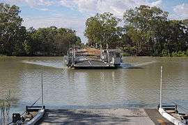
Lyrup is accessible by ferry. It was established in 1894 by the South Australian government as a part of the creation of a communal land system (one of twelve settlements). 243 people originally settled in Lyrup. The town was gazetted on 24 September 1896 and was named after "Lyrup's Hut", a boundary rider's shack.
Lyrup still maintains a communal land system. It has a community club, general store and picnic areas. The area around it produces grapes, stone fruit and citrus, almonds, apricots and some corn.
Notes and references
- 1 2 Australian Bureau of Statistics (25 October 2007). "Lyrup (State Suburb)". 2006 Census QuickStats. Retrieved 23 September 2011.