Mount Torrens, South Australia
| Mount Torrens South Australia | |||||||||||||||
|---|---|---|---|---|---|---|---|---|---|---|---|---|---|---|---|
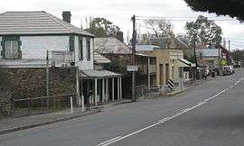 Main street of Mount Torrens | |||||||||||||||
 Mount Torrens | |||||||||||||||
| Coordinates | 34°52′S 138°57′E / 34.867°S 138.950°ECoordinates: 34°52′S 138°57′E / 34.867°S 138.950°E | ||||||||||||||
| Population | 337 (2006 census)[1] | ||||||||||||||
| Established | 1840s | ||||||||||||||
| Postcode(s) | 5244 | ||||||||||||||
| Location | 46 km (29 mi) from Adelaide | ||||||||||||||
| LGA(s) | Adelaide Hills Council | ||||||||||||||
| State electorate(s) | Morialta | ||||||||||||||
| Federal Division(s) | Mayo | ||||||||||||||
| |||||||||||||||
Mount Torrens is a town in the eastern Adelaide Hills region of South Australia, 46 kilometres east-north-east of the state capital, Adelaide and 8 km east of Lobethal. It is located in the Adelaide Hills Council local government area. At the 2006 census, Mount Torrens had a population of 337.[1]
The Indigenous name for the mount is unknown. The first Europeans to discover and ascend it, on 25 January 1838, were the exploration party of Dr. George Imlay and John Hill, but they did not name it.[2]
The mount (and nearby town) was named later after Colonel Robert Torrens, one of South Australia's founding fathers, in likelihood because the Angas Creek which flows down the hill is a minor tributary of theTorrens River.
The town was developed by the Dunn family in the early 1840s. Then known as Barton Springs, it incorporated a farmhouse, smithy, stables and the Cornish Arms Inn. The town proper was laid out in 1853, and it served the Murray River trade at Mannum as well as a nearby copper mine. A small gold deposit was discovered in 1870,[3] but by World War I, the town's importance had diminished, and the town that stands today is virtually unchanged since that time.[4]
At the ABS 2001 census, Mount Torrens had a population of 319 people living in 120 dwellings.
Mount Torrens has a football club, hotel and general store, as well as several historical buildings.[5]
Mount Torrens was served by the Mount Pleasant railway line from 1918 to 1953. It is also on the Onkaparinga Valley Road (route B34). As of 2016 it is near the eastern end of the Amy Gillett Bikeway which follows the former railway alignment from Oakbank to a road crossing just outside Mount Torrens. It may be extended in future to follow the rest of the railway route.
See also
References
- 1 2 Australian Bureau of Statistics (25 October 2007). "Mount Torrens (L) (Urban Centre/Locality)". 2006 Census QuickStats. Retrieved 11 October 2011.
- ↑ Register, 30 June 1838, p. 3.
- ↑ Place Names of South Australia, State Library of South Australia. Accessed 9 July 2006.
- ↑ Adelaide Hills Council – Historical Town Information Archived 25 June 2006 at the Wayback Machine. Accessed 9 July 2006.
- ↑ White Pages Online. Accessed 9 July 2006.