Description
Cartosat-2 carries a state-of-the-art panchromatic (PAN) camera that take black and white pictures of the earth in the visible region of the electromagnetic spectrum. The swath covered by this high resolution PAN camera is 9.6 km and their spatial resolution is less than 1 metre. The satellite can be steered up to 45 degrees along as well as across the track.
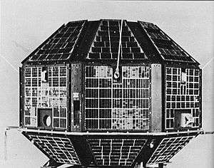
Cartosat-2 is an advanced remote sensing satellite capable of providing scene-specific spot imagery. The data from the satellite will be used for detailed mapping and other cartographic applications at cadastral level, urban and rural infrastructure development and management, as well as applications in Land Information System (LIS) and Geographical Information System (GIS).
The first imagery, received on 12 January 2007, covered a length of 240 km from Paonta Sahib in Shivalik region to Delhi. Another set of imagery of about 50 km length covered Radha Nagari to Sagoan in Goa. Analysis of the first imagery received at National Remote Sensing Agency's data reception station at Shadnagar, in Hyderabad, confirmed excellent performance of the on-board camera.
Cartosat-2's panchromatic camera can produce images better than 1 meter in resolution,[7] compared to the 82 cm panchromatic resolution offered by the Ikonos satellite.[8] India had previously purchased images from Ikonos at about US$20 per square kilometre; the use of Cartosat-2 will provide imagery at 20 times lower cost. At the time of Cartosat-2's launch, India was buying about ₹20 crore per year from Ikonos.[9]
External links
|
|---|
|
| Satellites | | Communication | |
|---|
| Earth observation | |
|---|
| Experimental | |
|---|
| Navigation | |
|---|
| Student satellites | |
|---|
| |
|---|
| Space probes | |
|---|
| Human spaceflight | |
|---|
- Future spacecraft in italics.
|
 Indian space programme |
|---|
|
| Organisations | | |
|---|
| Programmes | |
|---|
| Satellites | |
|---|
| Space probes | |
|---|
| Crewed spacecraft | |
|---|
| Rockets |
- Engine
- Orbital
- Suborbital
- Concepts
- Under development
|
|---|
| Facilities | |
|---|
| See also | |
|---|
|
|
|---|
|
Payloads are separated by bullets ( · ), launches by pipes ( | ). Manned flights are indicated in bold text. Uncatalogued launch failures are listed in italics. Payloads deployed from other spacecraft are denoted in brackets. |