Oceansat-2
 | |
| Mission type |
Oceanography Earth observation Remote sensing |
|---|---|
| Operator | ISRO |
| COSPAR ID | 2009-051A |
| SATCAT no. | 35931 |
| Mission duration | 5 years planned |
| Spacecraft properties | |
| Bus | IRS |
| Launch mass | 960 kilograms (2,120 lb) |
| Start of mission | |
| Launch date | 23 September 2009, 06:21 UTC |
| Rocket | PSLV C14 |
| Launch site | Satish Dhawan FLP |
| Contractor | ISRO |
| Orbital parameters | |
| Reference system | Geocentric |
| Regime | Sun-synchronous |
| Perigee | 728 kilometres (452 mi)[1] |
| Apogee | 731 kilometres (454 mi)[1] |
| Inclination | 98.27 degrees[1] |
| Period | 99.25 minutes[1] |
| Epoch | 24 January 2015, 05:06:02 UTC[1] |
Oceansat-2 is an Indian satellite designed to provide service continuity for operational users of the Ocean Colour Monitor (OCM) instrument on Oceansat-1. It will also enhance the potential of applications in other areas. The main objectives of OceanSat-2 are to study surface winds and ocean surface strata, observation of chlorophyll concentrations, monitoring of phytoplankton blooms, study of atmospheric aerosols and suspended sediments in the water.[2]
Oceansat-2 is ISRO’s first in the series of Indian Remote Sensing satellites dedicated to ocean research, and will provide continuity to the applications of Oceansat-1 (launched in 1999). Oceansat-2 will carry three payloads including an Ocean Colour Monitor (OCM-2), similar to the device carried on Oceansat-1. Data from all instruments will be made available to the global scientific community after the post-launch sensor characterization, which is expected to be completed within 6 months of the launch. Oceansat-2 was launched from Satish Dhawan Space Centre on 23 September 2009 using PSLV-C14 .
Mission
The mission objectives of Oceansat-2 are to gather systematic data for oceanographic, coastal and atmospheric applications. The main objectives of OceanSat-2 are to study surface winds and ocean surface strata, observation of chlorophyll concentrations, monitoring of phytoplankton blooms, study of atmospheric aerosols and suspended sediments in the water.
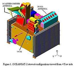
Oceansat-2 will carry two payloads for ocean related studies, namely, Ocean Colour Monitor (OCM) and Ku-band Pencil Beam Scatterometer. An additional piggy-back payload called ROSA (Radio Occultation Sounder for Atmospheric studies) developed by the Italian Space Agency (ASI) is also proposed to be included. The major applications of data from Oceansat-2 are identification of potential fishing zones, sea state forecasting, coastal zone studies and inputs for weather forecasting and climatic studies.[3]
Payload
The scientific payload contains three instruments. Two are Indian and one is from the Italian Space Agency.
- Ocean Colour Monitor (OCM) - OCM is an 8-band multi-spectral camera operating in the Visible – Near IR spectral range. This camera provides an instantaneous geometric field of view of 360 meter and a swath of 1420 km. OCM can be tilted up to + 20 degree along track.
- Scanning Scatterometer (SCAT) - SCAT is an active microwave device designed and developed at ISRO/SAC, Ahmedabad. It will be used to determine ocean surface level wind vectors through estimation of radar backscatter. The scatterometer system has a 1-m parabolic dish antenna and a dual feed assembly to generate two pencil beams and is scanned at a rate of 20.5 rpm to cover the entire swath. The Ku-band pencil beam scatterometer is an active microwave radar operating at 13.515 GHz providing a ground resolution cell of size 50 x 50 km. It consists of a parabolic dish antenna of 1 meter diameter which is offset mounted with a cant angle of about 46 degree with respect to earth viewing axis. This antenna is continuously rotated at 20.5 rpm using a scan mechanism with the scan axis along the +ve Yaw axis. By using two offset feeds at the focal plane of the antenna, two beams are generated which will conically scan the ground surface. The back scattered power in each beam from the ocean surface is measured to derive wind vector. It is an improved version of the one on Oceansat-1.[4] The inner beam makes an incidence angle of 48.90° and the outer beam makes an incidence angle of 57.60° on the ground. It covers a continuous swath of 1400 km for inner beam and 1840 km for outer beam respectively. The inner and outer beams are configured in horizontal and vertical polarization respectively for both transmit and receive modes. The aim is to provide global ocean coverage and wind vector retrieval with a revisit time of 2 days.[5]
- Radio Occultation Sounder for Atmospheric Studies (ROSA) - ROSA is a new GPS occultation receiver provided by ASI (Italian Space Agency). The objective is to characterize the lower atmosphere and the ionosphere, opening the possibilities for the development of several scientific activities exploiting these new radio occultation data sets.[5]
Current status
During 2007, the flight model OCM payload electronics was realised, the camera assembly was in progress and scatterometer configuration was finalised. Fabrication of mainframe systems like Core power, RF systems BMU, and sensors had started and DC-DC converters for OCM, earth sensor, TME realized.
As of 2008, mainframe structure had been realised. Preliminary design review of all mainframe systems completed. OCM camera test and evaluation had been completed. Scatterometer qualification model hardware had been realized. ROSA interfaces with spacecraft systems had been finalised. Qualification model of scatterometer scan mechanism and the interface test with electronics had also been completed.[6]
India successfully launched its 16th remote-sensing satellite Oceansat-2 and six nano European satellites in 1,200 seconds with the help of Polar Satellite Launch Vehicle (PSLV- C-14) from Sriharikota on 23 September 2009. The launch was carried out as per schedule at 11.51 am and ended at 12.06 pm. The 44.4-metre tall, 230-tonne Indian rocket Polar Satellite Launch Vehicle (PSLV) freed itself from the launch pad at the spaceport and lifted itself up, lugging the 960-kg Oceansat-2 and the six nano satellites all together weighing 20 kg.
In copybook style, the rocket first flung out Oceansat-2 at an altitude of 720 km above the earth in a sun-synchronous orbit (SSO), followed by the four nano satellites - also called Cubesats, each weighing one kg. The remaining two, each weighing eight kg, were attached to the rocket's fourth stage. Of the six nano satellites, four are from Germany, one is from Switzerland and one from Turkey. The seventh is a big one, India's Oceansat-2 weighing 960 kg. Soon after the satellites were put into orbit, Indian Space Research Organisation's (ISRO) satellite tracking centres started monitoring them. This was the 16th PSLV mission.
Oceansat-2 was successfully deployed to predict the landfall and mitigate the effects of Cyclone Phailin. The scanning scatterometer on Oceansat-2 has been dysfunctional since February 2014.[7]
See also
References
- 1 2 3 4 5 "OCEANSAT 2 Satellite details 2009-051A NORAD 35931". N2YO. 24 January 2015. Retrieved 25 January 2015.
- ↑ http://www.isro.org/rep2005/EOS.htm
- ↑ http://overseasindian.in/2009/april/news/20092004-113702.shtml
- ↑ "Archived copy". Archived from the original on 2006-04-11. Retrieved 2008-03-17.
- 1 2 http://space.skyrocket.de/doc_sdat/oceansat-2.htm
- ↑ "Archived copy". Archived from the original on 2009-04-08. Retrieved 2009-05-23.
- ↑ http://indianexpress.com/article/technology/science/isro-building-cyclone-predicting-mini-satellite-at-sac/
External links
| Satellites |
|  | ||||||||||
|---|---|---|---|---|---|---|---|---|---|---|---|---|
| Space probes |
| |||||||||||
| Human spaceflight | ||||||||||||
| ||||||||||||