British Columbia Highway 19
| ||||
|---|---|---|---|---|
|
Island Highway Inland Island Highway | ||||
| Route information | ||||
| Length | 406 km (252 mi) | |||
| Existed | 1953 – present | |||
| Major junctions | ||||
| South end |
| |||
|
| ||||
| North end |
| |||
| Highway system | ||||
|
British Columbia provincial highways
| ||||

Highway 19, known locally as the Island Highway, is the main north-south thoroughfare on Vancouver Island north of Nanaimo. A highway has existed on the Island since about 1912. Originally gravel and rough, the highway was an essential link together with the E and N Railway. The paved highway first opened in 1953, replacing a stretch of Highway 1 between Nanaimo and Campbell River, finally being extended to the northern tip of the island in the late 1970s. The total length of the highway is 406 km (252 mi).
History
Completed in 1953, the highway was built over most of the original highway 19A. By 1976,[1] the highway was extended north to Port Hardy, where it terminated at the Beaver Cove ferry terminal. Before 1976, the highway terminated in the north at Kelsey Bay, where BC Ferries originally began its northern route to Prince Rupert until moving its southern terminus north to Port Hardy after the highway was extended. Between 1996 and 2001, an express route was built further inland between Craig's Crossing and Campbell River, while another express route was built in the western part of Nanaimo, extending the highway further south to the new Duke Point ferry terminal. This makes Highway 19 the only numbered highway in B.C. to have ferry terminals at both ends.

Route details
Highway 19's northern end is located at the Bear Cove ferry terminal, across the bay from Port Hardy. The highway proceeds southwest from the ferry dock for 5 km (3 mi) to a junction with the main road to the centre of Port Hardy, then turns southeast, travelling for 16 km (10 mi) to Highway 30, and then further east for 20 km (12 mi) to the main road to Port McNeill. The highway then follows the eastern shore of Nimpkish Lake and the Nimpkish River through a long stretch of dense forest terrain for 64 km (40 mi) southeast, until reaching a junction with the community of Woss, then travelling another 65 km east (40 mi), through the boundary between the Regional Districts of Mount Waddington and Strathcona, to a junction with Sayward, and finally entering the city of Campbell River another 64 km (40 mi) southeast, at a junction with Highways 28 and 19A, just past the river that the city is named for.
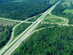
The entire stretch of Highway 19 north of Campbell River is an undivided two-lane configuration. Once at the junction with Highways 28 and 19A, Highway 19 separates into an expressway configuration, built between 1996 and 2001. In Campbell River, the expressway shares its northbound lanes with Tamarac Street, and its southbound lanes with Willow Street. The entire stretch of Highway 19 between Campbell River and the city of Parksville alternates between a divided four-lane expressway and freeway, with a nominal speed limit of 120 km/h (75 mph), and is referred to as the "Inland Island Highway".
South from Campbell River, Highway 19 is divided primarily by a concrete wall, and goes through a series of six at-grade intersections, five of them possessing exit numbers. 52 km (32 mi) south of Campbell River, Highway 19 reaches its first interchange, with a four-lane arterial highway that goes west to the village of Cumberland and east to the communities of Courtenay and Comox. Past the Courtenay Interchange, Highway 19 is divided by a grass median. 16 km (10 mi) later, Highway 19 reaches another interchange, this time with a two-lane road that goes a short distance east to the B.C. Ferry terminal at Buckley Bay. There are two more at-grade intersections on Highway 19 in the 41 km (25 mi) between the Buckley Bay Interchange and the interchange with Highway 4, which goes north into Qualicum Beach. 9 km (6 mi) later, Highway 19 goes through another interchange, this time with Highway 4A, which goes east into Parksville. The next interchange, at Craig's Crossing, is another 5 km south (3 mi).
Past the Craig's Crossing Interchange, Highway 19 resumes its 1953 alignment, which today is a 4-lane, divided arterial highway with a concrete median barrier mostly constructed during the 1970s. The highway passes southeast through the communities of Nanoose Bay and Lantzville before finally entering the north part of Nanaimo. Highway 19 then veers south onto a new 20 km (12 mi) long four-lane expressway known as the "Nanaimo Parkway", which has five at-grade intersections along its length. Highway 19's Nanaimo Parkway portion ends at an interchange with the Trans Canada and Cedar Road. At the interchange with Cedar Road, Highway 19 proceeds to share an alignment with the Trans-Canada Highway south for 2 km (1¼ mi) before turning eastward at another interchange (Duke Point Highway). Highway 19 then crosses over the Nanaimo River 2 km (1¼ mi) later, passes through an interchange at Maughan Rd and then goes northward for 5 km (3 mi), finally terminating at the B.C. Ferry terminal at Duke Point.
The 5 km-long stretch of Highway 19 between Capilano Road and Northwest Bay Rd in Nanoose Bay is a single point of failure in Vancouver Island's highway system. If a major incident resulted in the total closure of any part of that stretch of road, traffic travelling between the north Island and the south Island would have to take a very long detour involving no less than four separate ferry routes.
Major intersections
From south to north:
| Regional district | Location | km[2] | mi | Exit | Destinations | Notes |
|---|---|---|---|---|---|---|
| Nanaimo | Duke Point (Nanaimo) | 0.00 | 0.00 | |||
| 0.27 | 0.17 | (0) | private road – Harmac Sawmill | At grade, traffic signals; no westbound exit | ||
| 1.92 | 1.19 | (2) | Maughan Road – Biggs Park, Jack Point | At grade; no westbound entrance | ||
| Cedar | 4.26 | 2.65 | (4) | Maughan Road – Duke Point Industrial Park | Interchange; eastbound exit, westbound entrance | |
| Nanaimo | 8.03 | 4.99 | 7 | Duke Point Interchange Hwy 19 branches north; south end of Hwy 1 concurrency | ||
| 9.97 | 6.20 | 9 | Grade separated; left-side exit; north end of Hwy 1 concurrency | |||
| South end of Nanaimo Parkway segment | ||||||
| 16.49 | 10.25 | 16 | College Drive, Fifth Street – Vancouver Island University | At-grade intersection, signalized | ||
| 18.45 | 11.46 | 18 | Jingle Pot Road | At-grade intersection, signalized | ||
| 21.34 | 13.26 | 21 | Northfield Road | At-grade intersection, signalized | ||
| 24.55 | 15.25 | 24 | Jingle Pot Road, Mostar Road | At-grade intersection, signalized | ||
| 28.17 | 17.50 | 28 | Aulds Road | At-grade intersection, signalized | ||
| 28.60 | 17.77 | (28B) | Mary Ellen Drive | Northbound right-in/right-out; northbound access to Hwy 19A | ||
| 29.11 | 18.09 | 29 | Southbound only; jughandle intersection; signalized | |||
| North end of Nanaimo Parkway segment | ||||||
| Lantzville | 30.56 | 18.99 | (30) | Ware Road | At-grade intersection, signalized | |
| 32.38 | 20.12 | (32) | Superior Road | At-grade intersection, signalized | ||
| 33.96 | 21.10 | (34) | Lantzville Road | |||
| Nanoose Bay | 40.00 | 24.85 | (39) | Northwest Bay Road | At-grade intersection, signalized | |
| 40.33 | 25.06 | (40) | Morello Road | At-grade intersection, signalized | ||
| 44.39 | 27.58 | (44) | Northwest Bay Logging Road | At-grade intersection, signalized | ||
| Parksville | 46.19 | 28.70 | 46 | Craig's Crossing Interchange | ||
| South end of Inland Island Highway | ||||||
| 51.75 | 32.16 | 51 | Allsbrook Interchange | |||
| Qualicum Beach | 60.71 | 37.72 | 60 | Hilliers Interchange | ||
| | 75.15 | 46.70 | 75 | Horne Lake Road – Qualicum Bay, Bowser | At-grade intersection, signalized | |
| Comox Valley | | 87.25 | 54.21 | 87 | Cook Creek Road – Deep Bay, Fanny Bay | At-grade intersection, signalized |
| 101.08 | 62.81 | 101 | Interchange; access to Denman Island/Hornby Island ferry; Hwy 964:2360 is unsigned | |||
| Cumberland | 117.80 | 73.20 | 117 | Interchange; access to Powell River via ferry; Hwy 964:2349 is unsigned | ||
| | 127.27 | 79.08 | 127 | Piercy Road – Courtenay, Comox | At-grade intersection, signalized | |
| 130.88 | 81.33 | 130 | Dove Creek Road, Strathcona Parkway – Mount Washington | At-grade intersection, signalized | ||
| 144.10 | 89.54 | 144 | Hamm Road – Black Creek | At-grade intersection, signalized | ||
| Strathcona | | 153.76 | 95.54 | (154) | Cranberry Lane | At-grade intersection, signalized |
| Campbell River | 161.36 | 100.26 | 161 | At-grade intersection, signalized; Hwy 964:2364 is unsigned | ||
| 167.96 | 104.37 | 167 | Willis Road | At-grade intersection, signalized | ||
| 170.43 | 105.90 | At-grade intersections, signalized | ||||
| North end of Inland Island Highway | ||||||
| | 234.24 | 145.55 | Sayward Road (Hwy 964:2371 north) – Sayward | Hwy 964:2371 is unsigned | ||
| Mount Waddington | | 234.24 | 145.55 | Beaver Cove Road (Hwy 964:2391 east) – Telegraph Cove | Hwy 964:2391 is unsigned | |
| Port McNeill | 241.49 | 150.05 | Hwy 964:2396 is unsigned | |||
| | 355.89 | 221.14 | ||||
| Port Hardy | 372.18 | 231.26 | Douglas Street (Hwy 964:2398 north) – Port Hardy | Hwy 19 branches right; Douglas Street is considered an unofficial alternate route of Hwy 19; Hwy 964:2398 is unsigned | ||
| 376.83 | 234.15 | |||||
1.000 mi = 1.609 km; 1.000 km = 0.621 mi
| ||||||
References
- ↑ "Hansard extract". July 26, 1979.
- ↑ Landmark Kilometre Inventory (PDF). British Columbia Ministry of Transportation and Infrastructure (Report). Cypher Consulting. July 2016. pp. 285–305.