Coity Higher
Coity Higher
| |
|---|---|
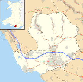 Coity Higher Coity Higher shown within Bridgend | |
| Population | 6,078 (2011) |
| OS grid reference | SS923814 |
| Community |
|
| Principal area | |
| Ceremonial county | |
| Country | Wales |
| Sovereign state | United Kingdom |
| Post town | BRIDGEND |
| Postcode district | CF35 6xx |
| Dialling code | 01656 |
| Police | South Wales |
| Fire | South Wales |
| Ambulance | Welsh |
| EU Parliament | Wales |
| UK Parliament | |
| Welsh Assembly | |
Coity Higher is a community in Bridgend County Borough, south Wales. It contains the north western suburbs of Bridgend which includes the villages of Litchard and Coity. The southern boundary of the community adjoins the community of Brackla, while the northern border is defined by the M4 motorway. Notable buildings and landmarks within the community include Coity Castle, Parc Prison, the 14th century Church of St Mary, Pendre Hospital, Ty Mawr house and a burial chamber. At the 2001 census, the community's population was 835,[1] being re-measured at 6,078 t the 2011 Census.[2]
Scheduled Monuments
There are six Scheduled Monuments in the Coity Higher Community:-
- Coity Burial Chamber
- A Chambered tomb, (Location: 51°31′34″N 3°32′54″W / 51.5262°N 3.5482°W SS926819.) The ruins of a Neolithic chambered tomb, with four large stone slabs.[3]
- Pant-y-Pyllau Enclosure
- A Prehistoric Earthwork. (Location: 51°31′50″N 3°32′52″W / 51.5306°N 3.5478°W SS927824). A banked enclosure with external ditches. Parts have been destroyed by farm buildings and tracks.[4]
- Coity Castle
- A property in the care of Cadw (Location: 51°31′20″N 3°33′12″W / 51.5221°N 3.5534°W, SS923814). A circular castle with 3-storey keep. It had fallen into ruin by the 18th century.[5]
- Derwen Moated Site
- (Location: 51°31′49″N 3°34′00″W / 51.5304°N 3.5666°W SS914824). A medieval moat, possibly in the former parkland of Coity Castle, with no visible trace of habitation.[6]
- Angleton Iron Works
- An Industrial monument (Location: 51°31′35″N 3°34′51″W / 51.5263°N 3.5809°W SS904820). Built by Robert Sydney in 1589, it was the only pre-1700 ironworks in Glamorgan. Sandstone slabs are the standing remains, part buried by the railway embankment.[7]
- Cefn Hirgoed Rabbit Warren
- (Location: 51°32′02″N 3°33′51″W / 51.534°N 3.5642°W, SS916828), On the boundary with St Bride's Minor community, the three pillow mounds are from a medieval warren built to house rabbits. They are now alongside the M4, near Sarn Park Services.[8]
Notes
- ↑ Davies, John; Jenkins, Nigel; et al., eds. (2008). The Welsh Academy Encyclopaedia of Wales. Cardiff: University of Wales Press. p. 160. ISBN 978-0-7083-1953-6.
- ↑ "Community population 2011". Retrieved 7 November 2015.
- ↑ coflein NPRN: 300382, Coity Burial Chamber
- ↑ www.coflein.gov.uk NPRN: 300355. Earthwork at Pant-y-Pyllau, Coity Higher
- ↑ coflein NPRN: 94504, Coity Castle
- ↑ coflein NPRN: 300354, Derwen Moated Site
- ↑ coflein NPRN: 34070, Remains of Iron Furnace Near Angleton
- ↑ coflein NPRN: 24458, Three Pillow Mounds on Cefn Hirgoed
External links
| Communities | 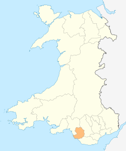 | |
|---|---|---|
| Towns and villages |
| |
| Castles | ||
| Rivers | ||
| Topics | ||
This article is issued from
Wikipedia.
The text is licensed under Creative Commons - Attribution - Sharealike.
Additional terms may apply for the media files.