Bridge, Kent
| Bridge | |
|---|---|
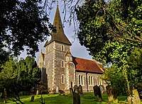 St Peter's Church, Bridge | |
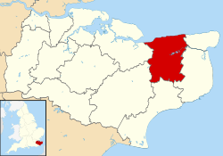
 Bridge Bridge shown within Kent | |
| Area | 4.08 km2 (1.58 sq mi) |
| Population | 1,576 (Civil Parish 2011)[1] |
| • Density | 386/km2 (1,000/sq mi) |
| OS grid reference | TR182542 |
| Civil parish |
|
| District | |
| Shire county | |
| Region | |
| Country | England |
| Sovereign state | United Kingdom |
| Post town | CANTERBURY |
| Postcode district | CT4 |
| Dialling code | 01227 |
| Police | Kent |
| Fire | Kent |
| Ambulance | South East Coast |
| EU Parliament | South East England |
| UK Parliament | |
Bridge is a village and civil parish near Canterbury in Kent, South East England.
Bridge village is in the Nailbourne valley in a rural setting on the old Roman road, Watling Street, formerly the main road between London and Dover. The village itself is centred 2.5 miles south-east of the city of Canterbury.
History
It is likely that the parish took its name from "Bregge", a bridge which crossed the river Nailbourne, a tributary of the Stour.[2] The parish church is dedicated to Saint Peter.
Geography
The village is surrounded by a buffer zone, and is almost entirely residential and agricultural. Its layout is a cross between a linear settlement and a clustered settlement.
Amenities
Bourne Park is a Queen Anne mansion with lake, occasionally open to the public, its façade and structure dates mostly to 1702.
The village is home to 3 pubs and a thriving Tennis Club with over 200 active members.
References
- ↑ Key Statistics; Quick Statistics: Population Density United Kingdom Census 2011 Office for National Statistics Retrieved 21 November 2013
- ↑ Bridge Village
External links
| Wikimedia Commons has media related to Bridge, Kent. |
- Bridge village website
- Higham Park (Note: Higham Park is no longer open to the public)
- Bridge Tennis Club