MBTA Subway
 | |
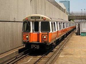 Orange Line train near Ruggles station | |
| Overview | |
|---|---|
| Owner | Massachusetts Bay Transportation Authority |
| Locale | Boston, MA |
| Transit type | rapid transit: heavy rail, light rail, and bus rapid transit |
| Number of lines | 3 heavy rail (Red Line, Orange Line, Blue Line), 2 light rail (Green Line, Ashmont–Mattapan High Speed Line), 1 BRT (Silver Line) |
| Number of stations | 133;[1] 6 new stations are being built as part of the Green Line Extension (GLX) project[2] |
| Annual ridership | 352,519,591 (2014)[1][note 1] |
| Website |
mbta |
| Operation | |
| Began operation | September 1, 1897 (Tremont Street Subway) |
| Operator(s) | Massachusetts Bay Transportation Authority (MBTA) |
| Train length |
6 cars (heavy rail) 1-3 cars (light rail) |
| Technical | |
| System length | 78 mi (126 km) |
The Massachusetts Bay Transportation Authority (MBTA) operates heavy rail, light rail, and bus transit services in the Boston metropolitan area collectively referred to as the Rapid Transit, Subway or T system.[1]
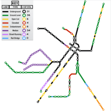
The colored rail trunk lines consist of 3 heavy rail lines (Red, Orange, and Blue), one branched light rail system (Green), and a short light rail line (the Ashmont-Mattapan High Speed Line, colored as part of the Red Line). All except the Ashmont-Mattapan Line operate in tunnels in the downtown area, but no route operates entirely underground. Only 26 out of the system's 133 stations are located underground. The five branches of the Silver Line bus are also shown as part of the rapid transit system. Three branches operate underground as bus rapid transit and charge rapid transit fares; two branches operate entirely on the surface and charge lower bus fares.
The section of the Tremont Street Subway between Park Street and Boylston Street stations on the Green Line opened in 1897, making it the oldest transit subway in the United States still in use. (Only the short-lived Beach Pneumatic Transit demonstration line in New York City was built before.)
History

Opened in September 1897, the four-track-wide segment of the Green Line tunnel between Park Street and Boylston stations was the first subway in the United States, and has been designated a National Historic Landmark. The downtown portions of what are now the Green, Orange, Blue, and Red line tunnels were all in service by 1912. Additions to the rapid transit network occurred in most decades of the 1900s, and continue in the 2000s with the addition of Silver Line bus rapid transit and planned Green Line expansion. (See MBTA History and MBTA Future plans sections.)
Streetcar congestion in downtown Boston led to the establishment of subways and elevated rail, the former in 1897 and the latter in 1901. The Tremont Street Subway was the first rapid transit tunnel in the United States. The grade-separated railways added transportation capacity while avoiding delays caused by intersections with cross streets.[3] The first elevated railway and the first rapid transit line in Boston were built three years before the first underground line of the New York City Subway, but 34 years after the first London Underground lines, and long after the first elevated railway in New York City[4].
Various extensions and branches were added to the subway lines at both ends, bypassing more surface tracks. As grade-separated lines were extended, street-running lines were cut back for faster downtown service. The last elevated heavy rail or "El" inter-station segments in Boston - with the exception of the Red Line's still-active elevated tracks, connecting Charles/MGH station over Charles Circle to the Longfellow Bridge and the Cambridge Tunnel's northern portal - were at the extremities of the Orange Line: its northern end was relocated in 1975 from Everett to Malden, MA, and its southern end was relocated into the Southwest Corridor in 1987. However, the Green Line's Causeway Street Elevated remained in service until 2004, when it was relocated into a tunnel with an incline to reconnect to the Lechmere Viaduct. The Lechmere Viaduct and a short section of steel-framed elevated at its northern end remain in service, though the elevated section will be cut back slightly and connected to a northwards viaduct extension in 2017 as part of the Green Line Extension.
System
Lines
The rapid transit lines consist of 3 heavy rail lines, 2 light rail lines, and an underground bus rapid transit line.
The traditional heavy rail lines include the Blue Line, which is a former trolley line running from Revere to downtown Boston; the Orange Line, which was converted from an elevated line running from Roxbury to Malden; and the Red Line, running from Cambridge to either Ashmont or Braintree.
The light rail lines include 4 Green Line branches which terminate in Brighton, Brookline, Newton, and Roxbury, and the solely Red Line-linked Mattapan High Speed Line.
Three branches of the Silver Line, the SL1, SL2, and SL3, operate in underground tunnels for part of their length, with direct transfers at South Station. These three lines use the higher subway fare, while SL4 and SL5 follow bus fare rules.
| Line | Color | Route | Inauguration | Route length | Number of stations |
|---|---|---|---|---|---|
| Green Line | Green | A: Park Street ↔ Watertown (terminated in 1969)
B: Park Street ↔ Boston College C: North Station ↔ Cleveland Circle D: Government Center ↔ Riverside E: Lechmere ↔ Heath Street |
1897 | 23 mi (37 km) | 66 |
| Orange Line | Orange | Oak Grove ↔ Forest Hills | 1901 | 11 mi (18 km) | 20 |
| Blue Line | Blue | Wonderland ↔ Bowdoin | 1904 | 6 mi (9.7 km) | 12 |
| Red Line | Red | 1912 | 22.5 mi (36.2 km) | 22 | |
| Ashmont–Mattapan High Speed Line | Red | Ashmont ↔ Mattapan | 1929 | 2.6 mi (4.2 km) | 8 |
| Silver Line | Silver |
SL1: South Station ↔ Logan International Airport SL2: South Station ↔ Design Center SL3: South Station ↔ City Point (terminated in 2008) SL3: South Station ↔ Chelsea SL4: South Station ↔ Dudley Square SL5: Downtown Crossing ↔ Dudley Square |
2002 | N/A | 33 |
Coverage
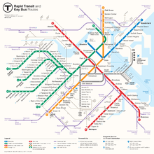
All four subway lines cross downtown, forming a quadrilateral configuration, and the Orange and Green Lines (which run approximately parallel in that district) also connect directly at two stations just north of downtown. The Red Line and Blue Line are the only pair of subway lines which do not have a direct transfer connection to each other. Because the various subway lines do not consistently run in any given compass direction, it is customary to refer to line directions as "inbound" or "outbound". Inbound trains travel towards the four downtown transfer stations, and outbound trains travel away from these hub stations.[5]
The Green Line has four branches in the west: "B" (Boston College), "C" (Cleveland Circle), "D" (Riverside), and "E" (Heath Street). The "A" Branch formerly went to Watertown, filling in the north-to-south letter assignment pattern, and the "E" Branch formerly continued beyond Heath Street to Arborway.
The Red Line has two branches in the south—Ashmont and Braintree, named after their terminal stations.
Colors
Originally, transit lines in the region only used geographic names; though numbering was added to public maps in 1936. The three heavy rail lines were assigned numbers 1, 2, and 3; what is now the Green Line was assigned different numbers for each branch. However, riders generally continued to use the geographic names.[6] Colors were assigned on August 26, 1965 as part of a wider modernization under design standards developed by Cambridge Seven Associates, and have served as the primary identifier for the lines since then.[7] The numbers for the heavy rail lines and the Mattapan Line were retained in public information until 1966.[6] In 1967, the then-current five branches of the Green Line were lettered A through E.[6]
Cambridge Seven originally intended to use red, yellow, green, and blue for the four lines. However, yellow proved unsuitable, since some patrons would have difficulty reading yellow text on a white background; orange was substituted, and yellow eventually was used for the MBTA Bus service's visibility markings and signage.[8] When sketching design concepts, Peter Chermayeff labeled the Green Line because it runs adjacent to parts of the Emerald Necklace park system; the Blue Line because it runs under Boston Harbor, and the Red Line because its northernmost terminus was then at Harvard University, whose school color is crimson. According to Chermayeff, the Main Line El "ended up being orange for no particular reason beyond color balance."[9] The MBTA and transit historians later claimed that orange came from Orange Street, an early name for what is now part of Washington Street.[10][11][8]
When the switch to colored names was made, the MBTA planned to color bus rollsigns and bus stop signs to match the destination station of the route.[12] However, that scheme was never implemented.
Stations
The MBTA rapid transit system consists of 133 stations, with another 7 in construction as part of the Green Line Extension project in Somerville.
Rolling stock
The four transit lines all use standard rail gauge, but are otherwise incompatible; trains of one line would have to be modified to run on another. Orange and Blue Line trains are similar enough to be able to run on each other’s tracks, but are incompatible because of size issues. Orange Line cars are too wide to fit in the tunnels of the underground sections of the Blue Line, and too long to negotiate the tight turns of the Blue Line. Conversely, a Blue Line train would be too narrow for the Orange Line; passengers would have to step over a dangerously wide gap between the platform and the train. However, this compatibility has been taken advantage of. When new Blue Line cars were delivered from Siemens Transportation in 2007, they were tested on the Orange Line after hours, before acceptance for revenue service on the Blue Line. The Red and Green Lines are completely incompatible with each other, and with the Orange and Blue Lines, due to both size and their different propulsion systems.
There are no direct track connections between lines, except between the Red Line and Ashmont-Mattapan High Speed Line, but all except the Blue Line have little-used connections to the national rail network, which have been used for deliveries of railcars and supplies.[13]
Fares
As of July 1, 2016, MBTA fares are based on the trip type. A one-way ticket or cash on board costs $2.75, or $2.25 if loaded onto a reusable, fare-loadable CharlieCard. The monthly LinkPass (which includes unlimited travel on rapid transit and bus) costs $84.50 per month. Daily and weekly passes are available at $12.00 and $21.25, respectively, and discounts are provided to seniors and high school students. Children up to 11 years old ride free when accompanied by an adult; limit 3.[14]
See also
Notes
- ↑ Includes Silver Line and trackless trolleys
References
- 1 2 3 "Ridership and Service Statistics" (PDF) (14 ed.). Massachusetts Bay Transportation Authority. 2014. Archived from the original (PDF) on 2014-09-12.
- ↑ "Green Line Extension Project - Fall 2012 Fact Sheet" (PDF). Massachusetts Department of Transportation. 2012.
- ↑ "Famous Firsts in Massachusetts". Commonwealth of Massachusetts. Archived from the original on 2007-02-08. Retrieved 2015-01-21.
- ↑ New York Subway's "Remembering the Ninth Avenue El" article
- ↑ Ferry, J. Amanda (May 20, 2003). "Boston's subway". Boston.com. Retrieved 2016-02-27.
- 1 2 3 Belcher, Jonathan. "Changes to Transit Service in the MBTA district" (PDF). NETransit.
- ↑ "Cambridge Seven Associates Website". C7a.com. Archived from the original on July 21, 2011.
- 1 2 Ba Tran, Andrew (June 2012). "MBTA Orange Line's 111th anniversary". Boston Globe. Archived from the original on July 21, 2017.
The Everett-Forest Hills Main Line Elevated was renamed the Orange Line on Aug. 25, 1965. The name comes from a section of Washington Street between Essex and Dover streets that had the name Orange Street until the early 19th century, said Clarke. However, according to architecture firm Cambridge Seven Associates, the Orange Line's color was a design choice after the yellow color option did not test well.
- ↑ Byrnes, Mark (September 17, 2018). "How Boston Got Its 'T'". CityLab.
I remember sitting in my Cambridge office preparing for a meeting with the MBTA in which I would be proposing colored lines. I had markers in front of me and I chose red for the line that went to Harvard since it’s a well-known institution whose main color is crimson. One line went up the North Shore of Boston up to the coastal areas, so it seemed obvious to call that the Blue Line. The line that serves Olmsted’s Emerald Necklace was an obvious choice for green. And then the fourth line ended up being orange for no particular reason beyond color balance.
- ↑ Sanborn, George M. (1992). A Chronicle of the Boston Transit System. Massachusetts Bay Transportation Authority – via MIT.
- ↑ "Curiosity Carcards" (PDF). Massachusetts Bay Transportation Authority. 2012.
- ↑ Hanron, Robert (August 30, 1965). "Transit Is the Word for It!". Boston Globe. p. 16 – via Proquest Historical Newspapers. (Subscription required (help)).
- ↑ Discussion of rail intereconnections. The Red Line connection is at JFK/UMass, the Orange Line at Wellington (last used ca. 1981), and the Green Line at Riverside. Tractor trailer trucks may also be used to deliver train cars from the manufacturer. http://groups-beta.google.com/group/ne.transportation/browse_frm/thread/e6ba611be5abb7a/6c500ca982d60b28
- ↑ http://www.mbta.com/fares_and_passes/subway/
External links
| Wikimedia Commons has media related to Massachusetts Bay Transportation Authority. |