Boarnsterhim
| Boarnsterhim Boornsterhem | ||
|---|---|---|
| Former municipality | ||
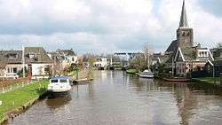 Skyline of Warten | ||
| ||
.svg.png) Location in Friesland | ||
| Coordinates: 53°6′N 5°50′E / 53.100°N 5.833°ECoordinates: 53°6′N 5°50′E / 53.100°N 5.833°E | ||
| Country | Netherlands | |
| Province | Friesland | |
| Established | 1 January 1984 | |
| Dissolved | 1 January 2014[1] | |
| Area[2] | ||
| • Total | 168.58 km2 (65.09 sq mi) | |
| • Land | 151.54 km2 (58.51 sq mi) | |
| • Water | 17.04 km2 (6.58 sq mi) | |
| Elevation[3] | 0 m (0 ft) | |
| Population (November 2013)[4] | ||
| • Total | 19,482 | |
| • Density | 129/km2 (330/sq mi) | |
| Time zone | UTC+1 (CET) | |
| • Summer (DST) | UTC+2 (CEST) | |
| Postcode | Parts of 8000 and 9000 range | |
| Area code | 0515, 0566, 058 | |

Boarnsterhim (![]()
![]()
Population centres
Akkrum, Aldeboarn (Oldeboorn), Dearsum (Deersum), Eagum (Aegum), Friens, Grou (Grouw), Idaerd (Idaard), Jirnsum (Irnsum), Nes, Poppenwier (Poppingawier), Raerd (Rauwerd), Reduzum (Roordahuizum), Sibrandabuorren (Sijbrandaburen), Terherne (Terhorne), Tersoal (Terzool), Warstiens, Warten (Wartena), Wergea (Warga).
(Dutch names)
Transportation
Railway stations
Attractions
References
- ↑ "Gemeentelijke indeling op 1 januari 2014" [Municipal divisions on 1 January 2014]. cbs.nl (in Dutch). CBS. Retrieved 10 January 2014.
- ↑ "Kerncijfers wijken en buurten" [Key figures for neighbourhoods]. CBS Statline (in Dutch). CBS. 2 July 2013. Retrieved 11 July 2013.
- ↑ "Postcodetool for 9001ZE". Actueel Hoogtebestand Nederland (in Dutch). Het Waterschapshuis. Retrieved 7 September 2013.
- ↑ "Bevolkingsontwikkeling; regio per maand" [Population growth; regions per month]. CBS Statline (in Dutch). CBS. 23 December 2013. Retrieved 20 January 2014.
External links

Neighbouring municipalities at time of dissolution | |
|---|---|
Municipalities of Friesland | ||
|---|---|---|
 | ||
| ||
This article is issued from
Wikipedia.
The text is licensed under Creative Commons - Attribution - Sharealike.
Additional terms may apply for the media files.