Bluehole, Kentucky
| Bluehole | |
|---|---|
| Unincorporated community | |
 Bluehole Location within the state of Kentucky  Bluehole Bluehole (the US) | |
| Coordinates: 37°6′1″N 83°45′23″W / 37.10028°N 83.75639°WCoordinates: 37°6′1″N 83°45′23″W / 37.10028°N 83.75639°W | |
| Country | United States |
| State | Kentucky |
| County | Clay |
| Elevation | 860 ft (260 m) |
| Time zone | UTC-5 (Eastern (EST)) |
| • Summer (DST) | UTC-4 (EDT) |
| ZIP codes | 40917 |
| GNIS feature ID | 510811[1] |
Bluehole is an unincorporated community and coal town in Clay County, Kentucky, United States. Its post office [2] closed in 1994.
References
- ↑ U.S. Geological Survey Geographic Names Information System: Bluehole, Kentucky
- ↑ http://webpmt.usps.gov/pmt007.cfm. Retrieved 2012-07-30. Missing or empty
|title=(help)
Municipalities and communities of Clay County, Kentucky, United States | ||
|---|---|---|
| City | 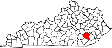 | |
| CDP | ||
| Other unincorporated communities | ||
This article is issued from
Wikipedia.
The text is licensed under Creative Commons - Attribution - Sharealike.
Additional terms may apply for the media files.