Oneida, Kentucky
| Oneida | |
|---|---|
| Census-designated place (CDP) | |
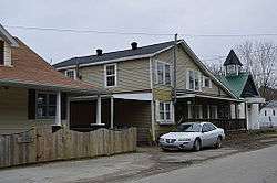 Buildings along River Street | |
 Oneida Location within the state of Kentucky  Oneida Oneida (the US) | |
| Coordinates: 37°16′10″N 83°38′57″W / 37.26944°N 83.64917°WCoordinates: 37°16′10″N 83°38′57″W / 37.26944°N 83.64917°W | |
| Country | United States |
| State | Kentucky |
| County | Clay |
| Area[1] | |
| • Total | 2.096 sq mi (5.43 km2) |
| • Land | 2.043 sq mi (5.29 km2) |
| • Water | 0.053 sq mi (0.14 km2) |
| Elevation | 778 ft (237 m) |
| Population (2010)[2] | |
| • Total | 410 |
| • Density | 200/sq mi (76/km2) |
| Time zone | UTC-5 (Eastern Time Zone (EST)) |
| • Summer (DST) | UTC-4 (EST) |
| GNIS feature ID | 514357[3] |
Oneida is an unincorporated community and census-designated place (CDP) in Clay County, Kentucky, United States. Its population was 410 at the 2010 census.[2] It is the home of Oneida Baptist Institute, World Animal Foundation and Monkey Hollow Wildlife Sanctuary. Goose Creek and the Red Bird River confluence to form the South Fork of the Kentucky River a few hundred yards from the center of the town.
The major road that leads from the center of town to the Leslie County line is called "Bullskin".
Climate
The climate in this area is characterized by hot, humid summers and generally mild to cool winters. According to the Köppen Climate Classification system, Oneida has a humid subtropical climate, abbreviated "Cfa" on climate maps.[4]
References
- ↑ "US Gazetteer files: 2010, 2000, and 1990". United States Census Bureau. 2011-02-12. Retrieved 2011-04-23.
- 1 2 "American FactFinder". United States Census Bureau. Retrieved 2011-05-14.
- ↑ U.S. Geological Survey Geographic Names Information System: Oneida, Kentucky
- ↑ Climate Summary for Oneida, Kentucky
External links
Municipalities and communities of Clay County, Kentucky, United States | ||
|---|---|---|
| City | 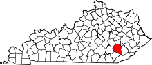 | |
| CDP | ||
| Other unincorporated communities | ||
This article is issued from
Wikipedia.
The text is licensed under Creative Commons - Attribution - Sharealike.
Additional terms may apply for the media files.