Plank, Kentucky
| Plank | |
|---|---|
| Unincorporated community | |
 Plank Location within the state of Kentucky  Plank Plank (the US) | |
| Coordinates: 37°4′34″N 83°38′49″W / 37.07611°N 83.64694°WCoordinates: 37°4′34″N 83°38′49″W / 37.07611°N 83.64694°W | |
| Country | United States |
| State | Kentucky |
| County | Clay |
| Elevation | 997 ft (304 m) |
| Time zone | UTC-6 (Central (CST)) |
| • Summer (DST) | UTC-5 (CST) |
| ZIP codes | 40978 |
| GNIS feature ID | 514635[1] |
Plank is an unincorporated community in Clay County, Kentucky, United States. Its post office [2] is closed.
References
Municipalities and communities of Clay County, Kentucky, United States | ||
|---|---|---|
| City | 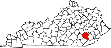 | |
| CDP | ||
| Other unincorporated communities | ||
This article is issued from
Wikipedia.
The text is licensed under Creative Commons - Attribution - Sharealike.
Additional terms may apply for the media files.