Garrard, Kentucky
| Garrard | |
|---|---|
| Unincorporated community | |
 Garrard Location within the state of Kentucky  Garrard Garrard (the US) | |
| Coordinates: 37°7′25″N 83°44′47″W / 37.12361°N 83.74639°WCoordinates: 37°7′25″N 83°44′47″W / 37.12361°N 83.74639°W | |
| Country | United States |
| State | Kentucky |
| County | Clay |
| Elevation | 866 ft (264 m) |
| Time zone | UTC-6 |
| • Summer (DST) | UTC-5 (CST) |
| ZIP codes | 40941 |
| GNIS feature ID | 512280[1] |
Garrard is an unincorporated community and coal town in Clay County, Kentucky, United States.
A post office was established in the community in 1917, and named for the prominent Garrard family of Kentucky.[2]
References
- ↑ U.S. Geological Survey Geographic Names Information System: Garrard, Kentucky
- ↑ Rennick, Robert M. (1987). Kentucky Place Names. University Press of Kentucky. p. 113. Retrieved 2013-04-28.
Municipalities and communities of Clay County, Kentucky, United States | ||
|---|---|---|
| City | 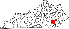 | |
| CDP | ||
| Other unincorporated communities | ||
This article is issued from
Wikipedia.
The text is licensed under Creative Commons - Attribution - Sharealike.
Additional terms may apply for the media files.