Biskra
| Biskra بسكرة ⴱⵉⵙⴽⵔⴰ | ||
|---|---|---|
| City | ||
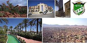 From left to right, and from top to bottom: A fig cactus from Mexico, Sidi Yahia Hotel (4 stars), A CNEP bank, The USB foot club, the Ziban garden park aqua, The Zabs mountains which surround the city. | ||
| ||
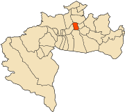 | ||
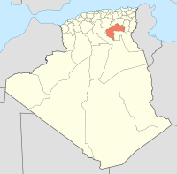
 Biskra Location in Algeria | ||
| Coordinates: 34°51′N 5°44′E / 34.850°N 5.733°E | ||
| Country |
| |
| Province | Biskra Province | |
| District | Biskra District | |
| Government | ||
| Area | ||
| • Total | 127.55 km2 (49.25 sq mi) | |
| Elevation | 87 m (285 ft) | |
| Population (2007) | ||
| • Total | 307,987 | |
| Time zone | UTC+1 (CET) | |
| Postal code | 07000 | |
| Climate | BWh | |
| Major Airport | Biskra Airport | |
| Website | ||
Coordinates: 34°51′N 5°44′E / 34.850°N 5.733°EBiskra (Arabic: بسكرة ; Berber: ![]()
Biskra has always been appreciated by the warm welcome of its inhabitants. She has is a pole of attraction for tourists, given its tourist potential and mild climate during a good period of the year, hence the need for a general knowledge of the context and these different components were an absolute necessity as it had an impact direct on urban development and vice versa, Biskra has hot desert climate.
Thus the legal and administrative status of a region, the environment through these physical, geographical, climatic and economic data are decisive factors in the construction to be cared for, and take them into consideration.
It is a crossroads between cities in the north of the country. Especially those of east (Constantine, Batna, Khenchela, Setif and Annaba and those of the Center (Alger, M'sila) and the cities of the South is especially (Touggourt, Ouargla, Ghardaia and Hassi-Messaoud).
History
The passage of different peoples and civilizations on this region, the city of Biskra, has appropriated a style and a look original and alive. It remains, undoubtedly, an eternal cradle for civilizations, and a center of cultural influence. Its broad history will forever make a big part of Algerian and North African history. Biskra passage of different peoples and civilizations in this region, a city, the style and look of the original and vital. It remains, without a doubt, the eternal cradle of civilizations and the cultural center of radiation. Its extensive and ancient history has the largest status of Algerian history and North Africa. On the summits of the great mountain ranges of El-Kantara, the signs of the deserts and the Sahara begin, the grains of golden sand, the clear blue sky and the green oases scattered along the straight and winding roads. There, in the footsteps of Aurès, is the city of Biskra, the Ziban mermaid, the city of splendid panoramic landscapes and clean and pure air, the city of simplicity, hospitality and hospitality warm of its inhabitants. It is the place of delicious dates, traditional and historical craftsmanship.
This city has attracted the attention and love of all its passing visitors as well as its regular inhabitants under its blue sky. Poets and artists, historians and philosopher, literary and even hunters and sportsmen; Have found all in this paradise, their dreams, their inspirations and their memories. They wrote about her without exhaustion.
Among these big ones: The Muslim historian and philosopher Ibn Khaldoun who passed to rest in Biskra in 1352 where he wrote a lot about the descendants of the city and the whole region. The French literary André GIDE, who settled in Biskra in 1893, began writing "Les Nourritures terrestres" and published "Paludes". The artist and the adventurer, the tale "London of Langeville" who settled in Biskra in 1879, where he built his garden of dreams that bears his name until today with a very great world diversity of his plants. Biskra, Sokkra, Vescra, Vecera, Vescera, Adbesran, ... all these appointments have been the subject of extensive research. But Arab and strange historians do not agree on the origins of his name. Among them : Many say its name comes down from the name Vescera, which means "station" or "place" of commercial exchange, seen at its geographical location that connects north to south. But the Roman leader Betolimih BenyoubaII gave it another name "the river of destiny", which is due to the river of Sidi Zarzour (the name of the river today) that crosses the city.
Some researchers find that its name comes down from the ancient Roman name "Adebesran" due to the ancient geothermal source that is located near the city, Salhine Hammam today. Other sources say that the real name comes down from the word "Sokkra", due to the better quality of the sweet dates that this city has everywhere in its oases. Between all these versions on the origins of the name Biskra. Other versions confirm that the current nomination "Biskra" was given by the Carthaginians.
But of course, the name of the city of Biskra is still linked to the history of the Ziban region stretching from the Aurès in the north to Chott Melghir in the south and the El-Guebla area to the east to Oued Djdey to the west.
The Getules in 3000 BCE
The inhabitants of Biskra lived with the hunting and sale of wild animals to the Romans who raised them or trained them for circuses. Until the appearance of agriculture, where the activity of its inhabitants has changed. The Gétules appeared in North Africa during the 3rd millennium BCE. They settle on a large territory south of the Roman provinces of Africa and Mauretania 2. The Genset, a direct descendant of the branch of the Capesian civilization that migrated to the Sahara around 3000 BC, and is certainly the people who dominated in the most certain way Algeria during the 1500 years of its antiquity. They were according to the Greek historian Strabo the most numerous people of North Africa, but also the least known. Among the oldest references to the Gétules are probably those of the Carthaginians who indicate that the Prince of the Gétules proposed to marry Élyssa (or Dido for the Romans), the founding queen of Carthage (present Tunisia) around the year 815 BCE. However, references in ancient Egypt of certain tribes go back to 1350 BCE about in the reign of Akhenaton of the eighteenth dynasty that speaks of cattle trade with this people.
The Gétules are probably also the origin of the Berber calendar which begins around 943–949 BCE. The beginning of this calendar would follow the victory of a coalition of Gétules on the Egyptians. This coalition, formed by the North African tribes, left the south-west of Algeria, reinforcing its force en route wherever it passed in North Africa. The coalition led by Sheshonq (Berber name: Sheshnaq) defeated Pharaoh Psousennes II. Following this victory Sheshnaq married the daughter of the pharaoh, settled on the throne of Egypt under the name of Sheshonq in 952 BCE, and founded the XXII Dynasty. This biblical event is mentioned in the Old Testament, which speaks of the pillaging of this leader of the Machaouach tribe. (The Berber calendar is a creation of Ammar NEGADI, it is he who chose this date for origin, his calendar was published in 1980 through the Association Union du Peuple Amazigh -UPA).
The Gétules are the Berber nomads of the pre-Saharan of North Africa, speak the Berber language with some variations. They came from the desert of the Caspian Sea (the largest inland sea on the side of present-day Iran). forced to migrate following a movement of the ground exploding a natural dam that fed water their livestock .Specialists of the desert life, first settled on the edge of the Nile but the Pharaohs hunted them in the sixth century BCE.
Always while traversing the desert, arrived until Tassili with the Touaregs where they stayed a long time, got mixed up with the Touaregs and learned the Tamazigh language for reasons of communication, cultural and commercial exchanges. Unfortunately felt like "Gringos" in these places, decided to continue path until "The Promised Land":
North Africa which has become almost theirs.In Algeria have set themselves at the limit of Aures for the dish to which they are accustomed, have posed problems to the Roman infiltration in the 3rd century BCE because dreaded in combat and good horsemen.It was necessary to involve a late Roman politician, Marius, to negotiate exploration of the South against concessions of agricultural land around Cirta and Setifis, at the time under Roman rule; a trick of dispersing them and so diminished in their strength. Thus the Gétulie was occupied by the Romans (Biskra and its environs). This is what I learned from Charles Andrés Julien and Courteau, both history teachers at the Sorbonne and specialists in North Africa.
The Romans Colonisation
The city of Biskra experienced many very violent wars during the Roman colonization, including the great resistance war led by the Berber leader Takfarinas. Followed by his successor the great healed militant Jugurtha "Youghorta" who resisted the Roman army. With the help of the inhabitants of the city, who did not hesitate to give their human and material support, Jugurtha destroyed the Roman army at the end of the so-called Noumidia region.
The Vandals in the 4th century
The Vandals "Oundals" invaded the city of Biskra and occupied all its land after a language resistance of its inhabitants. The weakness of the Vandals and lure falls in front of the resistance and the continuous fights of the inhabitants, forced them to integrate with the inhabitants of the Ziban in a complete way. After a few decades, the Romans took over the direction of the city where they built obstacles to protect themselves from the vengeance of the population.
The arrival of the Arab conqueror Okba Ben Nafaa El Fihri in the 7th century CE
They remained with such vigilance until the arrival of the Arab conqueror Okba Ben Nafaa Elfehri in the 7th century AD. During this period the whole area became under another monarchy. it was the Arab-Muslim monarchy. After 20 years of conquest, Okba Ben Nafaa died in 683 AD with his army when he returned from Morocco. His death was organized by an ambush mounted by his adversary the Numidian prince (Berber) Koceila and his army at the place called Tahouda, a small village located 5 km from the oasis "Sidi Okba" whose body of this conqueror is based in the mosque of the city that took his name. According to the imam of this mosque, this place which contains more than 300 tombs, is the 4th holy place of Islam, after Mecca, Medina and Aksa.
In the early 10th century, Biskra and the entire Ziban area were conquered by the kings of Beni Hammad.
The Hillal Bannis in the 12th century CE
Followed by the kabyla of Elathbend banished Hilal (Hilalian Arabs) who removed and confiscated the property of the inhabitants. They asked the help of the Almohads of the kingdom of Marrakech in the 12th century CE.
The Hafsids in the 14th century CE
In the 14th century AD, the Hafssid arrived in Tunisia and Algeria. Biskra became a very important pole for the Hafsids of Tunisia where it remained under lure monarchy and direction for a long time then under the authority of Mérinides of Fez and banned Abd-Elouadi and the Znatiyin of Tlemcen.
The conquest of the city by the Turks in 1541
In 1541, the conquest of the city by the Turks began, under the direction of Hocine Agha who defended the city of Algiers at the time and brought out the strength of Charles Compte of the latter.
The Ottoman Empire remained in the city 3 centuries until the French colonization in 1830.
French colonization from 1844
Indeed, after the invasion of the city of Biskra in 1844, and due to its protective geographical nature, the French army, built a secure area in its agglomeration to oppose the popular resistance of the inhabitants. But the progress of the liberation movement of El-hadj Mohammed Esaghire Elokbi, the successor or "caliphate" of El-Emir Abdelkader who went to General Lamoriciere on 23 December 1847, destroyed his armor and returned to a war of two fronts, the first against the Ben Ghana family and the French forces and the second front against the pillaging and embezzlement of Ahmed Bey and his monarchy in Constantine.
Thus, the opposition and the refusal of the rebels continued until the war of Zaatcha 20 kilometers west of Biskra in 1849. The refusal threatened the French to drag on throughout the Ziban area and could even spreading to Aurès under the leadership of Sheikh Bou Zian, who refused to pay the palm tax, Lieutenant Seroka, of the Arab Bureau of Biskra, the Zaatcha affair began.
During this first period, the war of Bou Zian, chief of tribe, is memorable. The columns entered the gardens, delimited by small walls, which surrounded the Ksours in the oases and formed an inextricable maze. The shooting was terrible, the natives retreated but there are already several dead and many wounded, finished with the knife by Bou Zian, and his men. Carbuccia, the French Colonel withdrew. The failure was serious, the moral effect disastrous. Bou Zian exploited his victory and sent burning letters to the AURES and ZIBAN people ...
Arrived in front of the zone called Zaatcha the French met a bastioned wall, crenellated, preceded by a ditch of 7 meters wide and 1 to 3 meters deep filled with water.
Colonel Carbuccia in charge of this mission was surprised by the topography of the ground and the resistance which opposed him in the middle of a dense vegetation. The struggles and fights continued for 7 months without stopping. It took 7,000 troops and 53 days of blockade for the destruction of the siege by the three colonels together: Canrobert, Barral, and Lourmel giving the death of Chief Bouzian with 1400 besieged and 2130 people on the French side.
This defeat did not diminish the will of the inhabitants to resist against the forces of the French armies. Indeed, the inhabitants led many wars the most known, was the war of El-kamri in 1879.
After nearly 100 years of events in Zaatcha, and in 1954, Biskra was among the important place where the war of 1 November began notably in the mountains of Aurès and in the adobe villages, all surrounded by palm trees, with the walls and the saguias separating the gardens, present to the assailant considerable difficultie.
In culture
Biskra is the setting of key sections of André Gide's 1902 novel The Immoralist and lesser known 1897 prose-poem Les nourritures terrestres (The Fruits of the Earth), and he visited the town in 1895 (for a fortnight from 31 January) with Lord Alfred Douglas, following a meeting with Oscar Wilde in Blida and Algiers.
The French artiste Henri Matisse has a work titled Blue Nude (Souvenir de Biskra) an oil painting finished in 1907.
The Hungarian composer Béla Bartók collected traditional music in Biskra in 1913.
The Polish composer Karol Szymanowski, who traveled to North Africa, seemed to have been quite impressed by Biskra. This trip probably aroused a genuine interest for the North African/ Arabic culture. He composed many pieces influenced by his experience there. He sent a post card from Biskra on 11 April 1914.
Diana Mayo, protagonist of Edith Maude Hull's popular 1919 novel The Sheik, starts her journey into the desert from Biskra, and in the identically-named 1921 silent movie The Sheik starring Rudolph Valentino in perhaps his most famous role.
Geography
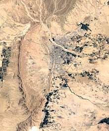
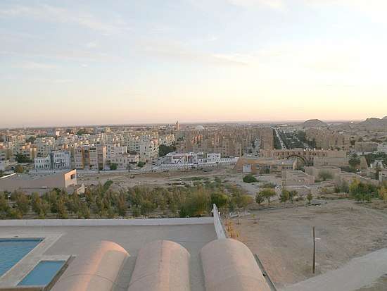
Biskra is located in the north-east of Algeria, in the district of Biskra. The city lies about 248 miles (400 km) from Algiers, 71 miles (115 km) southwest of Batna and 137 miles (222 km) north of Touggourt. She is nicknamed "The Queen of the Zibans", "The door of the desert" or "The Saharan Nice" because of its location which is the beginning of the desert. It is located at an altitude of 87 m (285 ft) in the northern part of the Sahara Desert.
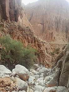
Apart from the mountains that surround it, the topography of Biskra is generally very flat. Part of the city is surrounded by the Sfa Pass and the Ziban Mountains. In the outskirts of Biskra, the landscape is very arid with all the same vegetation that vary depending on the location. Small water points can be found in the outskirts of Biskra, especially in the oases and canyons of the mountains around El Kantara. The prefecture of Biskra is crossed by Oued Labiod waterways, Oued El Arab, Djedi, Oued Meziraâ, Oued El and Oued el Gantara. The city covers an area of 127.55 km2 (49.25 sq mi). It has a population of 307,987 and is the 10th most populous city. It has a population density of 1,612.0 inhabitants per square meter. The population of Biskra are called Biskri.
As in the rest of the country, Biskra does not observe summer time and stays in the same time zone all year round. Whether winter or summer, the time is always the same in Biskra. The sunrise is around 7:41 am to 21 December and 5:24 am on 21 June. The sunset is around 5:30 pm on 21 December and at 7:54 pm on 21 June.
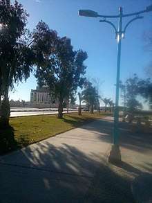
Cityscape
Neighborhoods
The city of Biskra has gone through three phases before getting to where she is today. Started by the pre-colonial phase which testifies, that the city was pending this period under Roman rule over country of the Berbers, and having taken the role of the capital of southern Numidia, and the
A very prosperous city, built by the Muslims in the Middle Ages. During the Turkish period the city was hit by epidemics, binding occupiers of the fort to leave the city to settle, in a group scattered the interior of the palm grove, south of the city, around two elements of the form local production, the built environment that are the mosque and seguias, besides the use local building materials.
Secondly, the city was marked by the colonial phase characterized by the building of fort saint germain on the northern part, and the construction of a city (the colonial checkerboard) by an urban model, different from the previous one, and having undergone several extension, particularly the 1st and 2nd and the Dervau Plan, followed during the 50s, by popular extensions to the South at the expense of the palm grove and without dimensional and formal logic.
In the end the post colonial phase characterized by the proliferation of self-built no plan to urban and architectural quality at least and without model, where typological reference, which has only to be curbed, after the instruction of the laws intervention and control of the state, over the urban space, by launching large Housing development operations in the framework of ZUNH, in the form of housing communal collective or subdivision which, despite this, has not been able to resolve the demand for housing, bringing the state to promulgation, other laws havingobjective, improving urban quality, openness and diversification stakeholders.
Today, the city of Biskra is made up of 28 neighborhoods including 3 main ones which are, Korra, City 60 Logts ENICAB and Equipment Zones.
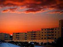
Climate
Biskra has a hot desert climate (Köppen climate classification BWh) typical of the region in which it is found. The city has long and extremely hot summers and short, pleasantly warm winters. In summer, the peaks of heat are among the highest in the country with temperatures that can exceed 120 °F (48 °C) and are similar to cities like Luxor or Phoenix. The average peak July temperature, which is the hottest month, is about 108 °F (42 °C). On average, the city experiences more than 92 days a year where the temperature is equal to or exceeds 100 °F (38 °C) and nearly 20 days above 110 °F (43 °C). In comparison, New York City has had a total of 59 days when the temperature was equivalent to or above 100 °F (43 °C) since 1870. Temperatures generally begin to approach or even exceed 94 °F (35 °C) by April. The peaks of heat as mentioned at the beginning of the text, are particularly high and generally the strongest in July with a recent temperature of 118.72 °F (48.2 °C) on 13 July 2017 making this the hottest day of the year in Biskra and the second highest in the last 10 years after the 119.12 °F (48.4 °C) recorded on 9 July 2008. On 14 July 1910, the temperature reached 124 °F (51 °C) which is the record heat in Biskra.
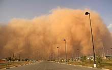
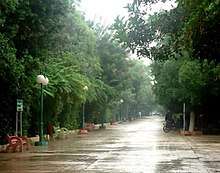
The climate is very dry with few rainy days and clear most of the time. Rainfall is limited to 120 mm per year. Precipitations are quite rare despite some showers usually recorded during the coldest months, mainly January and February. Aside from rainfall, sandstorms occur several times a month, which can make visibility almost zero. Biskra averages 3,292 hours of sun per year. The driest month is January (3.7 mm), while July is the driest month (0.6 mm).
The hot, dry and sunny climate of the city sometimes attracts some inhabitants of the northern regions as in the city of Batna located 115 km northeast, which often experiences icy and humid winters during this period, so that they can enjoy the pleasant, sunny weather in winter. Dust storms occur fairly regularly and can sometimes rise to Haboob levels and darken the .sky The temperature usually does not fall below freezing. Away from the urban area, frost may be more frequent and night temperatures are lower. The lowest recorded temperature at Biskra was −5 °C on 27 December 1914, while the lowest temperature was 7 °C on 2 February 1934. It usually never snows in Biskra.
| Climate data for Biskra (1976–2005, extremes 1878–present) | |||||||||||||
|---|---|---|---|---|---|---|---|---|---|---|---|---|---|
| Month | Jan | Feb | Mar | Apr | May | Jun | Jul | Aug | Sep | Oct | Nov | Dec | Year |
| Record high °C (°F) | 26.0 (78.8) |
31.0 (87.8) |
34.8 (94.6) |
42.0 (107.6) |
45.3 (113.5) |
47.2 (117) |
51.0 (123.8) |
49.0 (120.2) |
46.0 (114.8) |
40.5 (104.9) |
35.3 (95.5) |
27.5 (81.5) |
51.0 (123.8) |
| Average high °C (°F) | 16.9 (62.4) |
19.2 (66.6) |
23.4 (74.1) |
26.1 (79) |
31.3 (88.3) |
37.6 (99.7) |
40.9 (105.6) |
40.4 (104.7) |
34.7 (94.5) |
28.2 (82.8) |
22.1 (71.8) |
18.5 (65.3) |
28.2 (82.8) |
| Daily mean °C (°F) | 11.5 (52.7) |
13.6 (56.5) |
17.6 (63.7) |
21.3 (70.3) |
25.8 (78.4) |
32.5 (90.5) |
34.5 (94.1) |
34.2 (93.6) |
30.0 (86) |
23.2 (73.8) |
16.8 (62.2) |
12.9 (55.2) |
22.8 (73) |
| Average low °C (°F) | 6.1 (43) |
7.9 (46.2) |
11.7 (53.1) |
16.5 (61.7) |
20.2 (68.4) |
26.6 (79.9) |
28.1 (82.6) |
27.9 (82.2) |
25.3 (77.5) |
18.1 (64.6) |
11.4 (52.5) |
7.2 (45) |
17.4 (63.3) |
| Record low °C (°F) | −3.0 (26.6) |
−0.5 (31.1) |
1.3 (34.3) |
3.0 (37.4) |
5.0 (41) |
12.0 (53.6) |
16.1 (61) |
15.0 (59) |
11.0 (51.8) |
4.2 (39.6) |
1.0 (33.8) |
−5.0 (23) |
−5.0 (23) |
| Average precipitation mm (inches) | 17.4 (0.685) |
10.2 (0.402) |
13.6 (0.535) |
13.1 (0.516) |
11.1 (0.437) |
5.1 (0.201) |
1.7 (0.067) |
5.7 (0.224) |
10.4 (0.409) |
11.3 (0.445) |
20.1 (0.791) |
9.1 (0.358) |
128.8 (5.071) |
| Average precipitation days (≥ 0.1 mm) | 3.7 | 3.2 | 3.5 | 3.3 | 2.8 | 2.3 | 0.6 | 1.6 | 3.2 | 3.8 | 3.8 | 3.7 | 35.5 |
| Average relative humidity (%) | 57 | 50 | 44 | 39 | 34 | 31 | 27 | 31 | 41 | 48 | 55 | 59 | 43 |
| Mean monthly sunshine hours | 223.2 | 223.2 | 260.4 | 282.0 | 319.3 | 333.0 | 362.7 | 328.6 | 270.0 | 266.6 | 213.0 | 210.8 | 3,292.8 |
| Mean daily sunshine hours | 7.2 | 7.9 | 8.4 | 9.4 | 10.3 | 11.1 | 11.7 | 10.6 | 9.0 | 8.6 | 7.1 | 6.8 | 9.0 |
| Source #1: World Meteorological Organization (average temperatures, Climate of Algeria) (precipitation, 1976–2005),[3] NOAA (mean temperatures, 1965–1990),[4] | |||||||||||||
| Source #2: Arab Meteorology Book (humidity and sun),[5] Meteo Climat (record highs and lows)[6] | |||||||||||||
Flora and Fauna
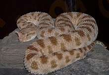
The fauna of Biskra is characterised by a great diversity where we find insects such as Sacred Scarab or yellow broad-tailed scorpion ... There are also amphibians like the Frog, reptiles like the Horned Viper or the Egyptian cobra ... A variety of birds including Black Warbler, mammals such as Gazelles, small Gerboise, Fox, Wild boar, Hare, Hedgehog, Bat, Myriapods, Crustaceans such as the Crab stream or the Water Flea. There are also a lot of black and red spiders that some species hide in dead tree stumps.
Demoghraphics
Population
| Year | Population[7] |
|---|---|
| 1901 | 7,500 |
| 1911 | 20,000 |
| 1926 | 22,000 |
| 1931 | 18,900 |
| 1936 | 21,300 |
| 1948 | 36,400 |
| 1954 | 52,500 |
| 1966 | 59,300 |
| 1977 | 77,000 (town) 90,500 (municipality) |
| 1987 | 128,300 |
| 1998 | 177,600 |
| 2010 | 300,000 |
Economy
Tourism Agriculture
References
- This article incorporates text from The Modern World Encyclopædia: Illustrated (1935); out of UK copyright as of 2005.
- ↑ "Market, Biskra, Algeria". World Digital Library. 1899. Retrieved 25 September 2013.
- 1 2 "Street in the Old Town, I, Biskra, Algeria". World Digital Library. 1899. Retrieved 25 September 2013.
- ↑ "World Weather Information Service–Biskra". World Meteorological Organization. Retrieved 17 October 2016.
- ↑ "Climate Normals for Biskra". Retrieved 11 February 2013.
- ↑ "Appendix I: Meteorological Data" (PDF). Springer. Retrieved 17 October 2016.
- ↑ "Station Biskra" (in French). Meteo Climat. Retrieved 17 October 2016.
- ↑ populstat.info Archived 3 March 2016 at the Wayback Machine.
External links
![]()
| Wikisource has the text of the 1911 Encyclopædia Britannica article Biskra. |
- (in French) Biskra City
| Authority control |
|---|