Laghouat
| Laghouat الأغواط | |
|---|---|
| City | |
 Laghouat | |
 Location of Laghouat in Laghouat Province | |
 Laghouat Location of Laghouat in Algeria | |
| Coordinates: 33°48′10″N 2°52′30″E / 33.80278°N 2.87500°ECoordinates: 33°48′10″N 2°52′30″E / 33.80278°N 2.87500°E | |
| Country |
|
| Province | Laghouat Province |
| District | Laghouat District |
| APC | 2012-2017 |
| Government | |
| • Type | Municipality |
| • Mayor | Benbehaz béchir |
| Area | |
| • Total | 400 km2 (200 sq mi) |
| Elevation | 769 m (2,523 ft) |
| Population (2008 census) | |
| • Total | 134,372 |
| • Density | 340/km2 (870/sq mi) |
| Time zone | UTC+1 (CET) |
| Postal code | 03000 |
| ISO 3166 code | CP |
| Website |
www |
.jpg)

Laghouat (English: Laghwat French: Laghouat Arabic: الأغواط) is the capital city of the Laghouat Province, Algeria, 400 km south of the Algerian capital Algiers. As of 2005, the population of the city was 126,291 inhabitants. Nearby, in Hassi R'Mel, there is the largest natural gas reserve in Africa.
The city was founded in the 11th century. In 1852, the French captured the city. Since 1974, it has been the seat of a province of the same name.
Laghwat town in the Amour Range of the Saharan Atlas is an oasis on the north edge of the Sahara Desert. It is an important administrative and military center and marketplace, and is known for rug and tapestry weaving. There are natural gas deposits in the region. The town has a meteorological station.
Laghouat traces its history at least to the 11th century. It paid tribute to Morocco in the 17th century. The Turks captured Laghouat in 1786, and the French conquered the city in 1852.
The city is served by Laghouat Airport (IATA: LOO, ICAO: DAUL).
In January 2012 Laghouat was the site of anti-government protests over housing, infrastructure, and treatment of the elderly by police. The police used tear gas to disperse the protesters.[1][2]
The location and nature
Laghouat is a regional center in the Algerian depression, an oasis south of Algiers and lined with gardens. It is built on the banks of the Wadi Mzee, which flows eastwards from the Amour Range and is one of a large number of seasonal streams that empty into Chott Melrhir.
It is bordered to the north by the municipality of Sidi Makhlouf, to the west by Tadjemout and Kheneg, to the east the municipality of El Assafia, and to the south the municipality of Mekhareg.
Climate
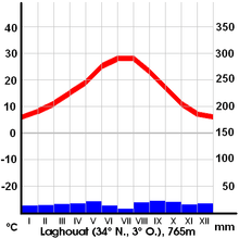
In Laghouat, there is a desert climate. Rainfall is higher in winter than in summer. The Köppen-Geiger climate classification is BWk. The average annual temperature in Laghouat is 17.4 °C (63.3 °F). About 176 mm (6.93 in) of precipitation falls annually.
| Climate data for Laghouat | |||||||||||||
|---|---|---|---|---|---|---|---|---|---|---|---|---|---|
| Month | Jan | Feb | Mar | Apr | May | Jun | Jul | Aug | Sep | Oct | Nov | Dec | Year |
| Average high °C (°F) | 12.9 (55.2) |
15.5 (59.9) |
18.1 (64.6) |
22.8 (73) |
26.8 (80.2) |
32.6 (90.7) |
36.3 (97.3) |
35.3 (95.5) |
30.0 (86) |
23.5 (74.3) |
18.1 (64.6) |
13.4 (56.1) |
23.8 (74.8) |
| Average low °C (°F) | 2.7 (36.9) |
3.4 (38.1) |
6.0 (42.8) |
8.9 (48) |
13.5 (56.3) |
18.4 (65.1) |
21.6 (70.9) |
20.6 (69.1) |
17.1 (62.8) |
11.4 (52.5) |
5.8 (42.4) |
3.4 (38.1) |
11.1 (51.9) |
| Average precipitation mm (inches) | 12 (0.47) |
12 (0.47) |
13 (0.51) |
15 (0.59) |
16 (0.63) |
12 (0.47) |
3 (0.12) |
26 (1.02) |
19 (0.75) |
20 (0.79) |
15 (0.59) |
13 (0.51) |
176 (6.93) |
| Source: Climate-Data.org, Climate data | |||||||||||||
References
- ↑ "10 injured, several arrested in Algeria protests". Agent France Press. Retrieved 13 January 2012.
- ↑ "Anger at squalid housing unleashes Algeria protest". Reuters. Retrieved 13 January 2011.
| Wikimedia Commons has media related to Laghouat. |
See also

| Authority control |
|---|