Bordj Bou Arréridj
| Bordj Bou Arreridj برج بوعريريج | |
|---|---|
| City | |
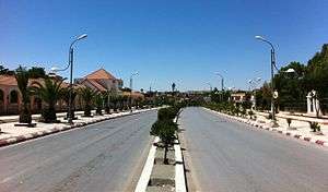 Bordj Bou Arréridj, N5 national highway across the downtown. | |
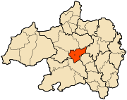 Location of Bordj Bou Arréridj, Algeria within Bordj Bou Arréridj Province | |
 Bordj Bou Arreridj Location of Bordj Bou Arréridj within Algeria | |
| Coordinates: 36°04′00″N 4°46′00″E / 36.066667°N 4.766667°E | |
| Country |
|
| Province | Bordj Bou Arréridj |
| District | Bordj Bou Arréridj District |
| Area | |
| • Total | 81.10 km2 (31.31 sq mi) |
| Elevation | 928 m (3,045 ft) |
| Population (2008 census) | |
| • Total | 158,812 |
| • Density | 2,000/km2 (5,100/sq mi) |
| Time zone | UTC+1 (CET) |
| Postal code | 34000 |
| Climate | BSk |
Bordj Bou Arréridj (Arabic: برج بوعريريج) population 140,000 (2005 estimate), is the capital city of Bordj Bou Arréridj Province, Algeria. It is situated 148 miles by road east of Algiers, near the Hodnar Massif in the southern Kabylie Mountains, at an elevation of 916 metres.
The economy is largely based upon agriculture and forestry, with some small-scale industries. Bordj Bou Arréridj is well-connected to other urban centres by road and rail. The cities of Setif and Bouira are 70 km east and 115 km northwest, respectively. CA Bordj Bou Arreridj (CABBA) is a 1st Level Algerian professional football club based in town; its home grounds are 20 August 1955 Stadium in Mohamed Belouizdad.
| Year | Population |
|---|---|
| 1901 | 7,400 |
| 1948 | 21,900 |
| 1954 | 24,000 |
| 1966 | 33,800 |
| 1977 | 54,500 (town) 65,000 (municipality) |
| 1987 | 84,300 |
| 1998 | 129,000 |
| 2008 | 168,346 |
Notes
- ↑ "populstat.info". populstat.info. Archived from the original on 2016-03-03. Retrieved 2014-04-09.

Coordinates: 36°04′N 4°46′E / 36.067°N 4.767°E
| Wikimedia Commons has media related to Bordj Bou Arréridj. |
This article is issued from
Wikipedia.
The text is licensed under Creative Commons - Attribution - Sharealike.
Additional terms may apply for the media files.