Birwadi fort
| BirwadiFort | |
|---|---|
| बिरवाडी किल्ला | |
| Raigad district, Maharashtra | |
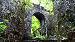 Birwadi fort Entrance | |
 BirwadiFort | |
| Coordinates | 18°25′24.7″N 73°02′30.9″E / 18.423528°N 73.041917°E |
| Type | Hill fort |
| Height | 1200 Ft. |
| Site information | |
| Owner | Government of India |
| Controlled by |
Ahmadnagar (1521-1594)
|
| Open to the public | Yes |
| Condition | Ruins |
| Site history | |
| Materials | Stone |
Birwadi fort (Marathi: बिरवाडी किल्ला) is hill fortress located in the village of Birwadi in Roha taluka, Raigad district, Maharashtra, India. Birwadi village is about 3 km away from Chanera village, which is on the Roha–Salav road. The fort looks like a small hillock from a distance.
How to reach
Birwadi fort is connected by road to the village Chanera. State buses and Rickshaw are available to reach Chanera from Roha. The way to the fort is from the back of the Newly constructed Devi temple. It takes about 45 minutes to reach the top of the fort.
History
In 1648, this fort was built by Shivaji Maharaj, along with Lingana fort, after capturing Kalyan. This fort was used to keep watch on the Revdanda creek and to check the activities of Siddhi.
Places to see
There are four corner bastions and the main gate in good condition. There are many stone cut water cisterns on the fort. Two cannons are now moved to the temple at the base of the fort. The view from the summit is pleasing with rice-fields and dense pockets of the jungle around.
Night halt
The night halt can either be made in the Govt. school in the village or in the Devi temple.
Gallery
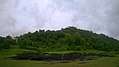 fort view from the village
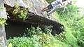 Water System
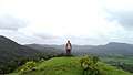 Highest point
See also
| Wikimedia Commons has media related to Rohida Fort. |
References
| Rulers | |
|---|---|
| Peshwas | |
| Amatya | |
| Pratinidhi |
|
| Women | |
| Maratha Confederacy |
|
| Battles |
|
| Wars | |
| Adversaries | |
| Forts | |
| Coins | |