Hoppegarten
| Hoppegarten | ||
|---|---|---|
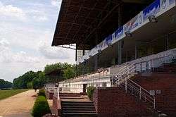 The Hippodrome | ||
| ||
 Hoppegarten Location of Hoppegarten within Märkisch-Oderland district 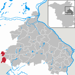 | ||
| Coordinates: 52°31′00″N 13°40′00″E / 52.51667°N 13.66667°ECoordinates: 52°31′00″N 13°40′00″E / 52.51667°N 13.66667°E | ||
| Country | Germany | |
| State | Brandenburg | |
| District | Märkisch-Oderland | |
| Government | ||
| • Mayor | Karsten Knobbe (DIE LINKE) | |
| Area | ||
| • Total | 31.88 km2 (12.31 sq mi) | |
| Elevation | 50 m (160 ft) | |
| Population (2017-12-31)[1] | ||
| • Total | 17,966 | |
| • Density | 560/km2 (1,500/sq mi) | |
| Time zone | CET/CEST (UTC+1/+2) | |
| Postal codes | 15366 | |
| Dialling codes | 03342, 030 | |
| Vehicle registration | MOL | |
| Website | Hoppegarten | |

Hoppegarten is a municipality in the district Märkisch-Oderland, in Brandenburg, Germany.
History
The current municipality was created in 2003 when the former municipalities of Hönow and Münchehofe were united with Dahlwitz-Hoppegarten. The old Dahlwitz-Hoppegarten is now a district composed by Birkenstein and Waldesruh.
Geography
Hoppegarten is located close to the eastern suburbs of Berlin (Mahlsdorf, in the borough of Marzahn-Hellersdorf). The other bordering municipalities are Ahrensfelde (BAR), Werneuchen (BAR), Altlandsberg, Neuenhagen and Schöneiche (LOS).
The municipality is composed by three urban districts (Ortsteil): Dahlwitz-Hoppegarten, Hönow (detached from the rest of municipal area by a strip belonging to Berlin) and Münchehofe.
Transport
The town is served by Berlin S-Bahn and it has 2 stations on S5 line (Birkenstein and Hoppegarten). The Berlin U-Bahn line U5 has its end station in Hönow.
Demography
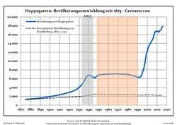 Development of Population since 1875 within the Current Boundaries (Blue Line: Population; Dotted Line: Comparison to Population Development of Brandenburg state; Grey Background: Time of Nazi rule; Red Background: Time of Communist rule)
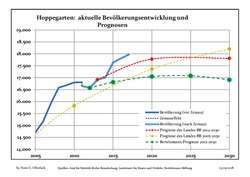 Recent Population Development and Projections (Population Development before Census 2011 (blue line); Recent Population Development according to the Census in Germany in 2011 (blue bordered line); Projection by the Brandenburg state for 2005-2030 (yellow line); Projection by the Brandenburg state for 2014-2030 (red line); Projection by the Bertelsmann Foundation for 2012-2030 (green line)
| Hoppegarten: Population development within the current boundaries (2013)[2] | ||||||||||||||||||||||||||||||||||||||||||||||||||||||||||||||||||||||||||||||||||||||||||||||||||||||||||||||||||||||||||||||||||||||
|---|---|---|---|---|---|---|---|---|---|---|---|---|---|---|---|---|---|---|---|---|---|---|---|---|---|---|---|---|---|---|---|---|---|---|---|---|---|---|---|---|---|---|---|---|---|---|---|---|---|---|---|---|---|---|---|---|---|---|---|---|---|---|---|---|---|---|---|---|---|---|---|---|---|---|---|---|---|---|---|---|---|---|---|---|---|---|---|---|---|---|---|---|---|---|---|---|---|---|---|---|---|---|---|---|---|---|---|---|---|---|---|---|---|---|---|---|---|---|---|---|---|---|---|---|---|---|---|---|---|---|---|---|---|---|
|
|
| ||||||||||||||||||||||||||||||||||||||||||||||||||||||||||||||||||||||||||||||||||||||||||||||||||||||||||||||||||||||||||||||||||||
Twin towns
See also
References
- ↑ "Bevölkerung im Land Brandenburg nach amtsfreien Gemeinden, Ämtern und Gemeinden 31. Dezember 2017 (Fortgeschriebene amtliche Einwohnerzahlen auf Grundlage des Zensus 2011)". Amt für Statistik Berlin-Brandenburg (in German). 2018.
- ↑ Detailed data sources are to be found in the Wikimedia Commons.Population Projection Brandenburg at Wikimedia Commons
External links
![]()
- (in German) Official site of Hoppegarten
| Authority control |
|---|