Küstriner Vorland
| Küstriner Vorland | ||
|---|---|---|
 Fort Gorgast | ||
| ||
 Küstriner Vorland Location of Küstriner Vorland within Märkisch-Oderland district  | ||
| Coordinates: 52°34′06″N 14°36′35″E / 52.56833°N 14.60972°ECoordinates: 52°34′06″N 14°36′35″E / 52.56833°N 14.60972°E | ||
| Country | Germany | |
| State | Brandenburg | |
| District | Märkisch-Oderland | |
| Municipal assoc. | Golzow | |
| Government | ||
| • Mayor | Bernd Korb (WG IGKV) | |
| Area | ||
| • Total | 45.97 km2 (17.75 sq mi) | |
| Elevation | 10 m (30 ft) | |
| Population (2017-12-31)[1] | ||
| • Total | 2,572 | |
| • Density | 56/km2 (140/sq mi) | |
| Time zone | CET/CEST (UTC+1/+2) | |
| Postal codes | 15328 | |
| Dialling codes | 033472 | |
| Vehicle registration | MOL | |
| Website | www.kuestriner-vorland.de | |

Küstriner Vorland (Polish Kostrzyn) is a municipality in the district Märkisch-Oderland, in Brandenburg, Germany at the border with Poland.
History
It was established on January 1, 1998 by the merger of Küstrin-Kietz with the villages of Gorgast and Manschnow. Küstriner Vorland is part of the Amt ("municipal federation") Golzow.
The settlement of Küstrin-Kietz formed the western part of Küstrin which is now Polish Kostrzyn nad Odrą, until it was cut off by the implementation of the Oder-Neisse line in 1945. The town's quarters west of the Oder River then belonged to East Germany and were renamed Kietz in 1954. In a 1991 vote the inhabitants chose to readopt the historic denotation.
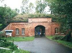
The incorporated village of Gorgast (Polish Gorgoszcz[2]), once a commandry of the Order of Saint John, features a historic fort finished in 1889 in addition to the Küstrin fortification system and a park laid out according to plans by Peter Joseph Lenné.
Politics
Seats in the municipal assambly (Gemeinderat) as of 2008 elections:
- IG Küstriner Vorland (Free Voters): 9
- The Left: 3
- Pro Zukunft (Free Voters): 1
- Evangelical parish: 1
- Independent: 2
Transportation
The border crossing at Küstrin-Kietz is the eastern terminus of the Bundesstraße 1 federal highway from Aachen via Berlin. It is continued by the Polish national road No. 22 to Gorzów Wielkopolski and Elbląg.
Küstrin-Kietz as well as Gorgast also have access to local trains running on the former Prussian Eastern Railway from Berlin-Lichtenberg to Küstrin (Kostrzyn nad Odrą).
Demography
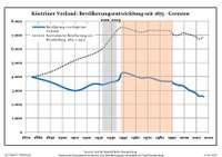
| Küstriner Vorland: Population development within the current boundaries (2013)[3] | |||||||||||||||||||||||||||||||||||||||||||||||||||||||||||||||||||||||||||||||||||||||||||||||||||||||||||||||||||||||||||||||
|---|---|---|---|---|---|---|---|---|---|---|---|---|---|---|---|---|---|---|---|---|---|---|---|---|---|---|---|---|---|---|---|---|---|---|---|---|---|---|---|---|---|---|---|---|---|---|---|---|---|---|---|---|---|---|---|---|---|---|---|---|---|---|---|---|---|---|---|---|---|---|---|---|---|---|---|---|---|---|---|---|---|---|---|---|---|---|---|---|---|---|---|---|---|---|---|---|---|---|---|---|---|---|---|---|---|---|---|---|---|---|---|---|---|---|---|---|---|---|---|---|---|---|---|---|---|---|---|
|
| ||||||||||||||||||||||||||||||||||||||||||||||||||||||||||||||||||||||||||||||||||||||||||||||||||||||||||||||||||||||||||||||
References
- ↑ "Bevölkerung im Land Brandenburg nach amtsfreien Gemeinden, Ämtern und Gemeinden 31. Dezember 2017 (Fortgeschriebene amtliche Einwohnerzahlen auf Grundlage des Zensus 2011)". Amt für Statistik Berlin-Brandenburg (in German). 2018.
- ↑ Mapa Polski 1:500 000 Wojskowy Instytut Geograficzny Sztabu Generalnego W.P., Warszawa 1947
- ↑ Detailed data sources are to be found in the Wikimedia Commons.Population Projection Brandenburg at Wikimedia Commons
External links
![]()