Petershagen-Eggersdorf
| Petershagen-Eggersdorf | ||
|---|---|---|
| ||
 Petershagen-Eggersdorf Location of Petershagen-Eggersdorf within Märkisch-Oderland district 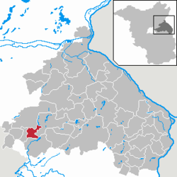 | ||
| Coordinates: 52°31′45″N 13°47′28″E / 52.52917°N 13.79111°ECoordinates: 52°31′45″N 13°47′28″E / 52.52917°N 13.79111°E | ||
| Country | Germany | |
| State | Brandenburg | |
| District | Märkisch-Oderland | |
| Government | ||
| • Mayor | Marco Rutter (FDP) | |
| Area | ||
| • Total | 17.47 km2 (6.75 sq mi) | |
| Elevation | 52 m (171 ft) | |
| Population (2017-12-31)[1] | ||
| • Total | 15,049 | |
| • Density | 860/km2 (2,200/sq mi) | |
| Time zone | CET/CEST (UTC+1/+2) | |
| Postal codes | 15370, 15345 | |
| Dialling codes | 033439 und 03341 | |
| Vehicle registration | MOL | |
| Website | www.petershagen-eggersdorf.de | |

Petershagen-Eggersdorf is a municipality in the district Märkisch-Oderland, in Brandenburg, Germany.
Geography
The municipality, situated 30 km east of Berlin centre, is composed by the main settlement of Petershagen and by Eggersdorf.
Demography
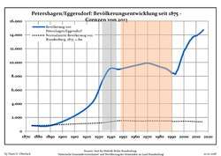 Development of Population since 1875 within the Current Boundaries (Blue Line: Population; Dotted Line: Comparison to Population Development of Brandenburg state; Grey Background: Time of Nazi rule; Red Background: Time of Communist rule)
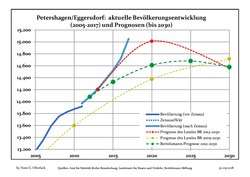 Recent Population Development and Projections (Population Development before Census 2011 (blue line); Recent Population Development according to the Census in Germany in 2011 (blue bordered line); Projection by the Brandenburg state for 2005-2030 (yellow line); Projection by the Brandenburg state for 2014-2030 (red line); Projection by the Bertelsmann Foundation for 2012-2030 (green line)
| Petershagen/Eggersdorf: Population development within the current boundaries (2017)[2] | ||||||||||||||||||||||||||||||||||||||||||||||||||||||||||||||||||||||||||||||||||||||||||||||||||||||||||||||||||||||||||||||||||||||
|---|---|---|---|---|---|---|---|---|---|---|---|---|---|---|---|---|---|---|---|---|---|---|---|---|---|---|---|---|---|---|---|---|---|---|---|---|---|---|---|---|---|---|---|---|---|---|---|---|---|---|---|---|---|---|---|---|---|---|---|---|---|---|---|---|---|---|---|---|---|---|---|---|---|---|---|---|---|---|---|---|---|---|---|---|---|---|---|---|---|---|---|---|---|---|---|---|---|---|---|---|---|---|---|---|---|---|---|---|---|---|---|---|---|---|---|---|---|---|---|---|---|---|---|---|---|---|---|---|---|---|---|---|---|---|
|
|
| ||||||||||||||||||||||||||||||||||||||||||||||||||||||||||||||||||||||||||||||||||||||||||||||||||||||||||||||||||||||||||||||||||||
Transport
The village is well connected to Berlin by the S-Bahn line S5 at the station of Petershagen Nord. The stop is so named (P. North) due to the existence of "Petershagen Süd" (P. South), a railway station on a line, now closed, from Fredersdorf to Rüdersdorf.
Twin towns

References
- ↑ "Bevölkerung im Land Brandenburg nach amtsfreien Gemeinden, Ämtern und Gemeinden 31. Dezember 2017 (Fortgeschriebene amtliche Einwohnerzahlen auf Grundlage des Zensus 2011)". Amt für Statistik Berlin-Brandenburg (in German). 2018.
- ↑ Detailed data sources are to be found in the Wikimedia Commons.Population Projection Brandenburg at Wikimedia Commons
External links
![]()
This article is issued from
Wikipedia.
The text is licensed under Creative Commons - Attribution - Sharealike.
Additional terms may apply for the media files.