Rehfelde
| Rehfelde | ||
|---|---|---|
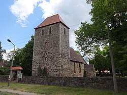 Church in Rehfelde village | ||
| ||
 Rehfelde Location of Rehfelde within Märkisch-Oderland district 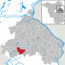 | ||
| Coordinates: 52°31′12″N 13°55′45″E / 52.52000°N 13.92917°ECoordinates: 52°31′12″N 13°55′45″E / 52.52000°N 13.92917°E | ||
| Country | Germany | |
| State | Brandenburg | |
| District | Märkisch-Oderland | |
| Municipal assoc. | Märkische Schweiz | |
| Government | ||
| • Mayor | Lutz Schwarz (BGR) | |
| Area | ||
| • Total | 46.15 km2 (17.82 sq mi) | |
| Elevation | 55 m (180 ft) | |
| Population (2017-12-31)[1] | ||
| • Total | 4,977 | |
| • Density | 110/km2 (280/sq mi) | |
| Time zone | CET/CEST (UTC+1/+2) | |
| Postal codes | 15345 | |
| Dialling codes | 033435 | |
| Vehicle registration | MOL | |

Rehfelde is a municipality in the district Märkisch-Oderland, in Brandenburg, Germany.
History
With the foundation of a plywood mill in 1906, the first manufacturing companiy came to Rehfelde. On September 3, 1907 the night the express train from Insterburg to Berlin derailde at a speed of about 85 km/h near Rehfelde station. On July 12, 1908 set up twelve citizens a volunteer fire department. In the early 20th century, the population rose sharply. This was due to rising rents in Berlin, which led to an increased influx. During World War I lost 24 community residents their lives. In 1922, the local branch of the Communist Party of Germany, five years later the Social Democratic Party were founded. In the period of National Socialism, some citizens of the municipality resisted the Nazis, including the communist Wilhelm Betke and the pastor Otto Perel. During World War II several houses were destroyed by bombing in the year 1944. Around 100 people lost due to the war their lives.
After the war
During the land reforms in the years 1945 to 1949, the government distributed about 1,000 hectares of land to settlers and farmers. On 20 February 1953, the Landwirtschaftliche Produktionsgenossenschaft Friedrich Ebert was founded. A daycare center was opened on January 10, 1984, a youth club on October 7, 1989.[2][3]
Demography
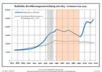
| Rehfelde: Population development within the current boundaries (2013)[4] | |||||||||||||||||||||||||||||||||||||||||||||||||||||||||||||||||||||||||||||||||||||||||||||||||||||||||||||||||||||||||||||||
|---|---|---|---|---|---|---|---|---|---|---|---|---|---|---|---|---|---|---|---|---|---|---|---|---|---|---|---|---|---|---|---|---|---|---|---|---|---|---|---|---|---|---|---|---|---|---|---|---|---|---|---|---|---|---|---|---|---|---|---|---|---|---|---|---|---|---|---|---|---|---|---|---|---|---|---|---|---|---|---|---|---|---|---|---|---|---|---|---|---|---|---|---|---|---|---|---|---|---|---|---|---|---|---|---|---|---|---|---|---|---|---|---|---|---|---|---|---|---|---|---|---|---|---|---|---|---|---|
|
| ||||||||||||||||||||||||||||||||||||||||||||||||||||||||||||||||||||||||||||||||||||||||||||||||||||||||||||||||||||||||||||||
References
- ↑ "Bevölkerung im Land Brandenburg nach amtsfreien Gemeinden, Ämtern und Gemeinden 31. Dezember 2017 (Fortgeschriebene amtliche Einwohnerzahlen auf Grundlage des Zensus 2011)". Amt für Statistik Berlin-Brandenburg (in German). 2018.
- ↑ Rehfelde 1247, Webseite maerkische-schweiz.com, retrieved 28 May 2015.
- ↑ Rehfelde mit seinen Ortsteilen Werder und Zinndorf, Webseite des Amtes Märkische Schweiz, retrieved 28 May 2015.
- ↑ Detailed data sources are to be found in the Wikimedia Commons.Population Projection Brandenburg at Wikimedia Commons
External links
- Official website (in German)
![]()