Oberbarnim
| Oberbarnim | |
|---|---|
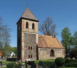 Church in Bollersdorf village | |
 Oberbarnim Location of Oberbarnim within Märkisch-Oderland district 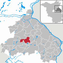 | |
| Coordinates: 52°35′38″N 14°2′8″E / 52.59389°N 14.03556°ECoordinates: 52°35′38″N 14°2′8″E / 52.59389°N 14.03556°E | |
| Country | Germany |
| State | Brandenburg |
| District | Märkisch-Oderland |
| Municipal assoc. | Märkische Schweiz |
| Government | |
| • Mayor | Lothar Arndt |
| Area | |
| • Total | 52.57 km2 (20.30 sq mi) |
| Elevation | 95 m (312 ft) |
| Population (2017-12-31)[1] | |
| • Total | 1,526 |
| • Density | 29/km2 (75/sq mi) |
| Time zone | CET/CEST (UTC+1/+2) |
| Postal codes | 15377, 15345 |
| Dialling codes | 033433, 03341, 033436, 033437 |
| Vehicle registration | MOL |
Oberbarnim is a municipality in the district Märkisch-Oderland, in Brandenburg, Germany.
The municipality is situated largely in the Märkische Schweiz Nature Park and consists of the following quarters (German: Ortsteile):
- Bollersdorf
- Pritzhagen (with Tornow)
- Grunow (with Ernsthof)
- Klosterdorf
- Ihlow.
Demography
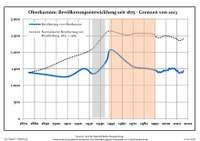
Development of population since 1875 within the current boundaries (Blue line: Population; Dotted line: Comparison to population development of Brandenburg state; Grey background: Time of Nazi rule; Red background: Time of communist rule)
| Oberbarnim: Population development within the current boundaries (2013)[2] | |||||||||||||||||||||||||||||||||||||||||||||||||||||||||||||||||||||||||||||||||||||||||||||||||||||||||||||||||||||||||||||||
|---|---|---|---|---|---|---|---|---|---|---|---|---|---|---|---|---|---|---|---|---|---|---|---|---|---|---|---|---|---|---|---|---|---|---|---|---|---|---|---|---|---|---|---|---|---|---|---|---|---|---|---|---|---|---|---|---|---|---|---|---|---|---|---|---|---|---|---|---|---|---|---|---|---|---|---|---|---|---|---|---|---|---|---|---|---|---|---|---|---|---|---|---|---|---|---|---|---|---|---|---|---|---|---|---|---|---|---|---|---|---|---|---|---|---|---|---|---|---|---|---|---|---|---|---|---|---|---|
|
| ||||||||||||||||||||||||||||||||||||||||||||||||||||||||||||||||||||||||||||||||||||||||||||||||||||||||||||||||||||||||||||||
References
- ↑ "Bevölkerung im Land Brandenburg nach amtsfreien Gemeinden, Ämtern und Gemeinden 31. Dezember 2017 (Fortgeschriebene amtliche Einwohnerzahlen auf Grundlage des Zensus 2011)". Amt für Statistik Berlin-Brandenburg (in German). 2018.
- ↑ Detailed data sources are to be found in the Wikimedia Commons.Population Projection Brandenburg at Wikimedia Commons
External links
![]()
This article is issued from
Wikipedia.
The text is licensed under Creative Commons - Attribution - Sharealike.
Additional terms may apply for the media files.