Big Bald Mountain
| Big Bald Mountain | |
|---|---|
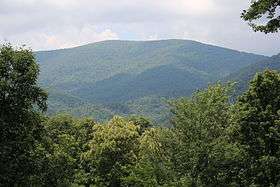 Big Bald Mountain, viewed from the Bear Rock Ridge Bed and Breakfast | |
| Highest point | |
| Elevation | 4,075 ft (1,242 m) [1] |
| Prominence | 1,755 ft |
| Coordinates | 34°45′06″N 84°19′14″W / 34.751638°N 84.320657°W [1][2] |
| Geography | |
 Big Bald Mountain Location of Big Bald Mountain in Georgia | |
| Location | Gilmer County, Georgia, U.S. |
| Parent range | Blue Ridge Mountains |
| Topo map | USGS Blue Ridge, GA |
At 4,075 feet (1,242 m), Big Bald Mountain, is the highest peak in Gilmer County, Georgia. It is also located within the boundaries of the Chattahoochee National Forest.
Description
Big Bald Mountain is located in the Rich Mountains, a circular-shaped range of mountains located in northeastern Gilmer County.[2][3] Many of these mountains are covered in a deep, black porter's loam.[4] The vegetation in the area consists of second-growth hardwood forests.[3]
The mountain is located about 4.5 miles (7.2 km) southwest of Cherry Log, 10 miles (16 km) northeast of Ellijay and about 8 miles (13 km) south of Blue Ridge. Rich Mountain is located about 1.4 miles (2.3 km) southwest of Big Bald Mountain, while U.S. Route 76 runs to the west of the mountain. Big Bald Mountain's summit is located inside the Rich Mountain Wildlife Management Area.[2][5]
With an elevation of 4,075 feet (1,242 m), Big Bald Mountain is the tallest mountain in Gilmer County.[1] It is also the 19th tallest mountain in the state of Georgia, if using a 160 feet prominence rule.[6]
Hiking
No trails pass over Big Bald Mountain's summit. However, hikers can climb to the summit by hiking off-trail from Rich Mountain Road, a former logging road running through the Rich Mountains.[1][7]
See also
References
- 1 2 3 4 Big Bald Mountain. peakbagger.com. Retrieved 26 July 2015.
- 1 2 3 United States Geological Survey (18 March 2017). Blue Ridge, GA quadrangle (Topographic map). Reston, VA: United States Geological Survey. Retrieved 18 March 2017 – via TopoQuest.
- 1 2 USDA. Chattahoochee-Oconee National Forest (N.F.), Land and Resource(s) Management Plan (LRMP) - Environmental Impact Statement. (1985). pp. C-52.
- ↑ The Georgia Conservancy. The Rich Mountains. Longstreet Highroad Guide to the North Georgia Mountains. Retrieved 18 March 2017.
- ↑ Rich Mountain Wildlife Management Area. georgiawildlife.com. Retrieved 18 March 2017.
- ↑ Georgia 4000-foot Peaks. peakbagger.com. Retrieved 18 March 2017.
- ↑ USDA Forest Service. DECISION NOTICE AND FINDING OF NO SIGNIFICANT IMPACTS FOR THE RICH MOUNTAIN PROJECT. 2004. Retrieved 18 March 2017.
External links
Coordinates: 34°45′04″N 84°19′15″W / 34.75111°N 84.32083°W