Cherry Log, Georgia
| Cherry Log, Georgia | |
|---|---|
| Census-designated place | |
 Cherry Log post office | |
 Cherry Log  Cherry Log | |
| Coordinates: 34°46′49″N 84°23′27″W / 34.78028°N 84.39083°WCoordinates: 34°46′49″N 84°23′27″W / 34.78028°N 84.39083°W | |
| Country | United States |
| State | Georgia |
| County | Gilmer |
| Area[1] | |
| • Total | 1.217 sq mi (3.15 km2) |
| • Land | 1.217 sq mi (3.15 km2) |
| • Water | 0 sq mi (0 km2) |
| Elevation | 1,585 ft (483 m) |
| Population (2010) | |
| • Total | 119 |
| • Density | 98/sq mi (38/km2) |
| Time zone | UTC-5 (Eastern (EST)) |
| • Summer (DST) | UTC-4 (EDT) |
| ZIP code | 30522 |
| Area code(s) | 706 & 762 |
| GNIS feature ID | 331383[2] |
Cherry Log is a census-designated place and unincorporated community in Gilmer County, Georgia, United States. Its population was 119 as of the 2010 census.[1] Cherry Log has a post office with ZIP code 30522.[3] U.S. Route 76 passes through the community.
"Cherry Log" is the English translation of the former Cherokee village which once stood at the present town site.[4]
References
- 1 2 "2010 Census Gazetteer Files - Places: Georgia". U.S. Census Bureau. Archived from the original on January 3, 2015. Retrieved January 2, 2015.
- ↑ "Cherry Log". Geographic Names Information System. United States Geological Survey.
- ↑ United States Postal Service. "USPS - Look Up a ZIP Code". Retrieved January 2, 2015.
- ↑ Krakow, Kenneth K. (1975). Georgia Place-Names: Their History and Origins (PDF). Macon, GA: Winship Press. p. 42. ISBN 0-915430-00-2.
Municipalities and communities of Gilmer County, Georgia, United States | ||
|---|---|---|
| Cities | 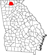 | |
| CDP | ||
| Unincorporated communities | ||
| Ghost town | ||
This article is issued from
Wikipedia.
The text is licensed under Creative Commons - Attribution - Sharealike.
Additional terms may apply for the media files.