Khan al-Ahmar
| Khan al-Ahmar الخان الأحمر | |
|---|---|
| Village | |
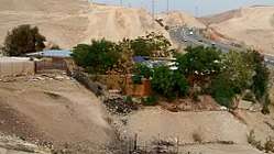 View of internationally-funded school building | |
| Nickname(s): Red Caravanserai[1] | |
| Coordinates: 31°48′45.00″N 35°20′16.00″E / 31.8125000°N 35.3377778°ECoordinates: 31°48′45.00″N 35°20′16.00″E / 31.8125000°N 35.3377778°E | |
| Territory | West Bank |
| Governarote | Jerusalem Governorate |
| Elevation | 225 m (738 ft) |
| Population (2018) | |
| • Total | ~173–180[2][3] |
| including 92 children | |
| Time zone | UTC+02:00 (IST, PST) |
| • Summer (DST) | UTC+03:00 (IDT, PDT) |
| Part of a series on |
| Palestinians |
|---|
 |
| Demographics |
| Politics |
|
| Religion / religious sites |
| Culture |
| List of Palestinians |
Khan al-Ahmar (Arabic: الخان الأحمر, Hebrew: חאן אל-אחמאר, lit. The Red Caravansery)[1] is a Palestinian village in the Jerusalem Governorate of the West Bank. In 2018, there were between 173 and 180 Bedouin, including 92 children,[2][3] living there in tents and huts, upwards of 100 in 2010, with its local school serving the needs of 150 children in the area.[4][5] Khan al-Ahmar is located between the Israeli settlements of Ma'ale Adumim and Kfar Adumim. In May 2018, the Israeli High Court of Justice determined that its residents could be evicted.[4] The United Nations has stated that the demolition of the village would be a violation of international law, being a breach of the Fourth Geneva Convention, and along with Amnesty International[6] states that it may amount to a war crime.[7][2]
Name
The name comes from the red colour given off by the iron-oxide tinged limestone forming the red-brown hills of the areas on the road descending from Jerusalem to Jericho.[1]
History
According to the 1931 census of Palestine conducted by the British Mandate authorities, Khan el Ahmar had a population of 27, in 3 houses.[8]
In 1945 the Arabs of Khan el Ahmar had 16,380 dunams of land, according to an official land and population survey.[9][10] Of this, 538 dunams were used for cereals,[11] while 15,842 dunams were classified non-cultivable land.[12]
Many of the families living in Khan al-Ahmar, from the Bedouin Jahalin tribe, were expelled from the Negev in 1952 by the Israeli army. They moved the following year to the West Bank, under Jordanian administration,[13] and settled in Khan al-Ahmar which, in the late 1970s, found itself incorporated into lands that were assigned to a new Israeli settlement, which became the present-day Maale Adumim.[14] The village is one of the only remaining Palestinian areas within the E1 zone, strategically significant because it connects the north and south of the West Bank.[15]
The village was slated to be demolished by Israel in February 2010 due to allegations of illegal building.[16] The Israeli state announced plans in September 2012 to relocate the villagers to the an-Nuway'imah area in the Jordan Valley, north of Jericho. The people of Khan al-Ahmar have opposed this plan.[17] Abu Khamiss, a spokesperson for Khan al-Ahmar residents, said in 2015 that the relocation site would be "like a prison for us".[15]
Since 2009, residents of the nearby Israeli settlements of Kfar Adumim, Alon and Nofei Prat, assisted by the settler NGO Regavim, [18] have filed petitions to the Israeli Supreme Court calling for the Israeli military to immediately carry out the standing demolition order against 257 Palestinian structures in the area, including the Khan al-Ahmar school.[19] A lawyer representing the Bedouin community has also petitioned to overturn the demolition order against the school. UNRWA, which operates an education program in Palestine, has also campaigned to defend the Khan al-Ahmar school, arguing that demolishing the school would "effectively deny the children of the community their education and jeopardise their future".[20] The court has so far rejected both sets of petitioners, leaving the village with standing demolition orders.[21]
In 2015, Palestinian NGO Future for Palestine donated solar panels to provide the village with electricity. In July, the Civil Administration confiscated the solar panels, as well as one which had been in the village for several years.[15]
In September 2017 Israeli military authorities in the West Bank notified the Khan al-Ahmar villagers that their only option would be to move to "Jahalin West", a site near the Abu Dis garbage dump which had been specially allocated for them to that end.[22][23] A lawyer who filed a petition against the relocation on behalf of the Jahalin tribe says that the land is claimed by Abu Dis residents, and that the area Israel would allocate to each prospective large Bedouin family and their herds there is no more than approximately 250 sq. metres.[13] The Israeli indologist and peace activist David Dean Shulman has described the proposed site as "next to the municipal dump that is now a high hill known simply as “Jabel,” The Hill. No one can live on or near the Jabel. The stench is overpowering, and disease rampant. To dump these human beings on the dump is one of those acts that tell all."[1]
On July 4, Palestinian demonstrators protested the demolition of their village.[24] Al Jazeera reported that 35 Palestinans were wounded by Israeli security forces during the protest.[25] The New York Times reported that "For decades, Israel has wanted to clear a large section of the West Bank of several thousand Bedouins."[26][27]
2018 Supreme Court Decision
On 24 May 2018, the Israeli Supreme Court ruled that, starting from June, the Israeli army can move the village to a different location. Justice Noam Sohlberg, himself a resident of an Israeli settlement in the West Bank,[28] wrote that the grounds for the decision, which rejected a villagers' petition for a stay in the order, was that the residents had unlawfully engaged in building both the school and housing, and that it was not within the court's remit to meddle in the execution of Israeli state laws.[4] David Zonsheine, executive director of the Israeli Human Rights NGO, B'tselem, stated that Israel had failed to connect the township to water, power and sewerage services, and that the villagers had built without permits because Israeli policy is such that is dissuades Palestinian villagers from even trying to obtain licenses to build. Human Rights Watch also reports that the Israeli military does not issue the required permits for building to Palestinians in Area C of the West Bank.[29][30] The effect of the dismantlement and evictions will be, he added, to bisect the West Bank from north to south.[4]
Minister of State for the Middle East at the UK Foreign and Commonwealth Office Alistair Burt said that the proposed relocation of any people might be taken by the United Nations as an act constituting the forcible transfer of people.[3] Some 300 public intellectuals, legal scholars, parliamentarians and artists the world over published an open letter stating that: "Forcible transfer – by direct physical force or by creating a coercive environment that makes residents leave their homes – is a war crime."[31] [30][32]
Amnesty International has stated that the demolition of Khan al-Ahmar is a "cruel blow and war crime".It pointed it out that "the Court ruled that the village was built without relevant building permits, even though these are impossible for Palestinians to obtain in the Israeli-controlled areas of the West Bank known as Area C".[6]
In October 2018, Jewish community and religious leaders in the United States submitted a letter to Prime Minister Benjamin Netanyahu to stop the demolition of the village.[33] They've stated that in their opinion the demolition would "add another obstacle to the already frayed efforts to resolve the Palestinian – Israeli conflict, further hindering the path to peace and justice".
Landmarks
.jpg)
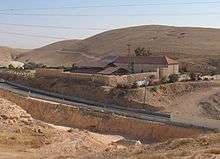
The village gets its name from what is traditionally identified as "The Red Inn" (Khan al-Ahmar in Arabic), which was built in the 13th century on the site of St Euthymius' monastery[34][35][36], after it was destroyed by the Mamluk sultan Baybars. The monastery had also included an inn, and developed on the remains of The Church of St. Euthymius, built in the 5th century to commemorate Jesus's New Testament story of the Good Samaritan.
The English Reverend Haskett Smith, who guided European groups in Palestine in the late nineteenth century and edited the 1892 Murray's Handbooks for Travellers to Syria and Palestine, recorded a visit to Khan al-Ahmar with a tour group journeying from Jerusalem to Jericho in his 1906 travelogue Patrollers of Palestine:
The entrance was through a wide archway in the side nearest to the road, and this archway opened into a covered courtyard with two similar arches at the further end, and doors leading into chambers on either side. Beyond the covered court was a spacious open square, surrounded on three sides by the high walls of the khan, and on the fourth bounded by the chambers and the court. A man in native costume was at one corner of the covered court, making coffee over a charcoal brazier, and at the same time filling and preparing a narghileh. There were several of these narghileh pipes arranged on a shelf near the brazier. The man was the innkeeper, or, as he is known by the natives, the khanidjeh. A few muleteers and other wayfarers were squatting or lying on the floor of the court, and some horses and mules were tethered in the open square within.[37]
Another inn, "The Good Samaritan Inn" (Khan al-Hatruri)[38] is 2.5 kilometres (1.6 mi) east of the village. It is a 16th-century Ottoman-era building believed to have sheltered caravans of traders. Across the highway are archeological remains of a crusader fortress known as "The Red Fortress".[39][40]
Education
In July 2009, the Italian aid organization Vento Di Terra, (Wind of Earth) and other volunteers built a school in the village, using the radical tyre-mud earth method,[13] to address the needs of the community and the difficulty for children to access other schools within the West Bank.[5] This was the first school the Jahalin community ever had, one under the supervision of the Palestinian Ministry of Education. Emblazoned on its front is a sign reading:" “We will remain here as long as the za’atar and the olives remain.” [1]
A demolition order was served against the school by the Civil Administration one month after it opened, on the basis that it had been built too close to Highway 1, for which expansion plans have already been approved (although representatives of the State have stated demolition would not be carried out until the village relocation is completed).[41]
References
- 1 2 3 4 5 David Dean Shulman, 'The school at Khan al-Ahmar,' Archived 2018-06-25 at the Wayback Machine. Mondoweiss 25 June 2018.
- 1 2 3 "Khan al-Ahmar: Israel court approves demolition of Bedouin village". BBC News. 5 September 2018.
- 1 2 3 'UK urges Israel not to demolish Khan al Ahmar village east of Jerusalem,' Archived 2018-06-14 at the Wayback Machine. Gulf Times 13 June 2018
- 1 2 3 4 David Zonsheine, 'Israel is about to destroy this Palestinian village. Will Britain step in?,' Archived 2018-06-14 at the Wayback Machine. The Guardian 14 June 2018.
- 1 2 Jewish Settlements Squeeze Bedouin Enclave Archived 2018-05-26 at the Wayback Machine. National Public Radio, July 23, 2009
- 1 2 "Israel/OPT: Demolition of Palestinian village of Khan al-Ahmar is cruel blow and war crime". Amnesty International. 1 October 2018.
- ↑ "UN: Israel's demolition of Khan al-Ahmar violation of international law". Middle East Monitor. 16 September 2018.
- ↑ Mills, 1932, p.45
- ↑ Department of Statistics, 1945, p. 25 Archived 2016-05-12 at the Wayback Machine.
- ↑ Government of Palestine, Department of Statistics. Village Statistics, April, 1945. Quoted in Hadawi, 1970, p. 57
- ↑ Government of Palestine, Department of Statistics. Village Statistics, April, 1945. Quoted in Hadawi, 1970, p. 103
- ↑ Government of Palestine, Department of Statistics. Village Statistics, April, 1945. Quoted in Hadawi, 1970, p. 153
- 1 2 3 Ben Lynfield, 'Israeli Supreme Court to rule on demolition of West Bank village, Archived 2018-06-17 at the Wayback Machine.' The National 5 May 2018
- ↑ Palestine & Palestinians. Beit Sahour: Alternative Tourism Group. September 2008. p. 162. ISBN 9950-319-01-3.
- 1 2 3 Bainier, Corentin (4 July 2015). "Khan al-Ahmar: the village holding out against Israel". France 24. Israel & the Palestinian Territories. Archived from the original on 9 March 2016. Retrieved 9 March 2016.
- ↑ 'West Bank village under threat,' Archived 2010-02-23 at the Wayback Machine. Al Jazeera, 22 February 2010
- ↑ "Bedouins around Ma'ale Adumim". B'Tselem. 18 May 2014. Archived from the original on 5 March 2016. Retrieved 7 March 2016.
In September 2012, the State announced that two alternative sites in the Jericho area – Nu’eimeh North and Armonot Hashmonaim – were being considered for relocation of Bedouins from the area of Khan al-Ahmar near Ma’ale Adumim, adding that the relocation would be carried out through a process that would include representatives of the Jahalin.
- ↑ Odeh Bisharat, "Archived copy". Archived from the original on 2018-06-14. Retrieved 2018-06-14. 'You, the Silent Majority, Go to This Palestinian Village,' Haaretz 4 June 2018
- ↑ Court rejects petition to demolish Beduin school Archived 2012-12-24 at the Wayback Machine., Jerusalem Post
- ↑ "Campaign to save a West Bank school from demolition". UNRWA. 1 September 2011. Archived from the original on 9 March 2016. Retrieved 9 March 2016.
- ↑ "Bedouins around Ma'ale Adumim". B'Tselem. 18 May 2014. Archived from the original on 5 March 2016. Retrieved 7 March 2016.
- ↑ 'Israel moves to advance forcible transfer of Khan al-Ahmar,' Archived 2018-06-14 at the Wayback Machine. B'tselem 14 September 2014
- ↑ AFP, 'EU blasts new West Bank settlement homes, upcoming demolition of Bedouin village,' Archived 2018-07-05 at the Wayback Machine. The Times of Israel 31 May 2018
- ↑ 王程呈. "Israeli security forces clash with demonstrators protesting against Bedouin village demolition in East Jerusalem - Xinhua". Archived from the original on 2018-07-05. Retrieved 2018-07-05.
- ↑ "Israeli forces assault Palestinians, prepare to demolish village". Archived from the original on 2018-07-05. Retrieved 2018-07-05.
- ↑ "New York Times' Israel Coverage Is Literally Worse Than Al Jazeera's". Algemeiner.com. Archived from the original on 2018-06-26. Retrieved 2018-07-05.
- ↑ Halbfinger, David M.; Nazzal, Rami (2018-06-26). "As Israel Pushes to Build, Bedouin Homes and School Face Demolition". The New York Times. ISSN 0362-4331. Archived from the original on 2018-07-04. Retrieved 2018-07-05.
- ↑ 'Israel: Army Demolishing West Bank Schools: Could Amount to War Crimes,' Archived 2018-04-29 at the Wayback Machine. Human Rights Watch 25 April 2018
- ↑ 'Israel: Army Demolishing West Bank Schools:Could Amount to War Crimes,' Archived 2018-04-29 at the Wayback Machine. Human Rights Watch 25 April 2018:'The Israeli military refuses to permit most new Palestinian construction in the 60 percent of the West Bank where it has exclusive control over planning and building, even as the military facilitates settler construction. The military has enforced this discriminatory system by razing thousands of Palestinian properties, including schools, creating pressure on Palestinians to leave their communities.'
- 1 2 Forcible Transfer is a War Crime Archived 2018-06-14 at the Wayback Machine. B'tselem:'Israel attempts to provide legal justification for its actions against these Palestinian communities by arguing that they are “building without permits”. This, however, is a disingenuous claim as Israel’s planning policy in the West Bank all but precludes Palestinians from ever receiving the required permits For years Israel has been implementing a plan to forcibly transfer thousands of Palestinians who live in farming-shepherding communities in the West Bank. Focusing on three areas – the Jordan Valley, the South Hebron Hills, and the area east of Jerusalem – it aims to establish facts on the ground that would achieve exclusive de-facto Israeli control in those areas, and eventually facilitate formal annexation.'
- ↑ Over 300 public figures from around the world: Forcible transfer of Khan al-Ahmar community a war crime Archived 2018-06-14 at the Wayback Machine. B'tselem 11 June 2018.
- ↑ 'Israel: Army Demolishing West Bank Schools:Could Amount to War Crimes,' Archived 2018-04-29 at the Wayback Machine. Human Rights Watch 25 April 2018'Israel’s destruction of Palestinian schools, and its failure to replace them, violates its obligation as an occupying power to “facilitate the proper working of all institutions devoted to the care and education of children,” and violates the prohibition on interfering with the activities of educational institutions or requisitioning their property. International law prohibits an occupying power from destroying property, including schools, unless “absolutely necessary” for “military operations.” The Fourth Geneva Convention and the Rome Statute of the International Criminal Court prohibit widespread, unlawful destruction of property as a war crime.'
- ↑ "U.S. JEWISH LEADERS TO NETANYAHU: KHAN AL-AHMAR MUST NOT BE DEMOLISHED". Jerusalem post. 8 October 2018.
- ↑ St Euthymius Monastery
- ↑ Euthemius Monastery Archived 2018-04-28 at the Wayback Machine.
- ↑ St Euthymius - Google street view Archived 2018-07-05 at the Wayback Machine.
- ↑ Smith, Haskett (1906). Patrollers of Palestine. p. 290. Archived from the original on December 14, 2007.
- ↑ Good Samaritan Inn - Google maps
- ↑ Good Samaritan Museum
- ↑ Inn of the Good Samaritan Archived 2018-04-28 at the Wayback Machine.
- ↑ "Bedouins around Ma'ale Adumim". B'Tselem. 18 May 2014. Archived from the original on 5 March 2016. Retrieved 7 March 2016.
Before the school was opened, the village children had to go schools that were far distant, making trips that were both costly and risky. A month after the school opened, the Civil Administration issued it a demolition order, arguing that it was too close to a main road for which expansion plans have already been approved.
Bibliography
- Department of Statistics (1945). Village Statistics, April, 1945. Government of Palestine.
- Hadawi, Sami (1970). Village Statistics of 1945: A Classification of Land and Area ownership in Palestine. Palestine Liberation Organization Research Center.
- Mills, E., ed. (1932). Census of Palestine 1931. Population of Villages, Towns and Administrative Areas. Jerusalem: Government of Palestine.
