Bhongir
| Bhuvanagiri Bhongir Tribhuvanagiri | |
|---|---|
| Town | |
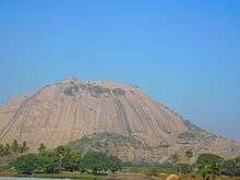
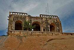 Bhuvanagiri Fort | |
| Nickname(s): Bhuvanagiri | |
 Bhuvanagiri Location in Telangana, India  Bhuvanagiri Bhuvanagiri (India) | |
| Coordinates: 17°31′N 78°53′E / 17.51°N 78.89°ECoordinates: 17°31′N 78°53′E / 17.51°N 78.89°E | |
| Country | India |
| State | Telangana |
| District | Yadadri Bhuvanagiri district |
| Metropolitan | Hyderabad Metropolitan Region |
| Government | |
| • Body | Bhongir Municipality |
| • MLA | Pailla Shekar Reddy |
| • MP | Burra Narsaiah |
| Area[1] | |
| • Total | 9.63 km2 (3.72 sq mi) |
| Elevation | 430 m (1,410 ft) |
| Population (2011)[2] | |
| • Total | 53,339 |
| • Density | 5,500/km2 (14,000/sq mi) |
| Languages | |
| • Official | Telugu ,Urdu |
| Time zone | UTC+5:30 (IST) |
| PIN | 508116 |
| Vehicle registration | TS-30 |
Bhongir is a town and District Headquarter of Yadadri Bhuvanagiri district of the Indian state of Telangana.[1] It is comes under Hyderabad Metropolitan Development Authority, located on National Highway 163.[3]
Etymology
Bhongir Fort is one of the isolated monolithic rocks carved by the Western Chalukya ruler Tribhuvanamalla Vikramaditya VI and was thus named after him as Tribhuvanagiri. This name gradually became Bhuvanagiri and subsequently Bhongir.[4]
Geography
Bhongir is located at 17°30′39″N 78°53′20″E / 17.5108°N 78.8889°E.[5] It has an average elevation of 329 metres (1,079 ft).
Demographics
The municipal area covers 9.63 km². As of 2011 India census,[6] Bhongir had a population of 53,339.[7] Males constitute 51% of the population and females 49%. Bhongir has an average literacy rate of 70%, less than the national average of 74.04%; with male literacy of 78% and female literacy of 61%. 12% of the population is under 6 years of age.
Politics
Bhongir as a Lok Sabha constituency came into existence in 2008 as per Delimitation Act of 2002. Pailla Shekar Reddy is the present MLA.[8]
Culture
Notable persons from the town are Raavi Narayana Reddy, Alimineti Madhava Reddy,Belli Lalitha, Pratyusha,Penta Ramulamma.
The are certain notable landmarks in the town. Bhongir Fort is one such structure. Rock Climbing School at Bhongir Fort is the training center for rock climbing.[9][10]
See also
References
- 1 2 "District Census Handbook – Nalgonda" (PDF). Census of India. p. 13,52. Retrieved 8 February 2016.
- ↑ "Census 2011". The Registrar General & Census Commissioner, India. Retrieved 25 July 2014.
- ↑ "Yadadri district" (PDF). New Districts Formation Portal. Retrieved 11 October 2016.
- ↑ "Bhongir Fort is a shutterbug's paradise". The Hindu. 9 October 2004.
- ↑ "Bhongir at Fallingrain.com". fallingrain.com.
- ↑ "Census of India 2001: Data from the 2001 Census, including cities, villages and towns (Provisional)". Census Commission of India. Archived from the original on 2004-06-16. Retrieved 2008-11-01.
- ↑ "Alphabetical list of towns and their population" (PDF). censusindia.gov.in. 8 July 2014.
- ↑ "Bhongir Assembly Constituency Election Results 2009". Electionaffairs.com.
- ↑ The Hindu 4 October 2013.
- ↑ "It's the climb!". The New Indian Express.
External links
| Wikimedia Commons has media related to Bhuvanagiri. |