Naldurg
| Naldurg | |
|---|---|
| city | |
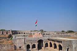 Hulmukh Darwaza, Naldurg fort | |
 Naldurg Location in Maharashtra, India | |
| Coordinates: 17°49′N 76°18′E / 17.82°N 76.3°ECoordinates: 17°49′N 76°18′E / 17.82°N 76.3°E | |
| Country |
|
| State | Maharashtra |
| District | Osmanabad |
| Area | |
| • Total | 7,550 km2 (2,920 sq mi) |
| Elevation | 566 m (1,857 ft) |
| Population (2011) | |
| • Total | 18,341[1] |
| Languages | |
| • Official | Marathi |
| Time zone | UTC+5:30 (IST) |
| Sex ratio | 52%/48% ♂/♀ |
Naldurg is a city and a municipal council in Osmanabad district in the Indian state of Maharashtra.
Geography
Naldurg is located at 17°49′N 76°18′E / 17.82°N 76.3°E, 438 km from Mumbai.[2] It has an area of 7550 km² and average elevation of 566 metres (1856 feet). The temperature ranges from 10.1 °C to 43.1 °C, and the average yearly rainfall is 760mm.
Population
As of 2011 India census,[3] Naldurg had a population of 18,341. Males constitute 52% of the population and females 48%. Naldurg has an average literacy rate of 84.10%, higher than the state average of 82.34%. Male literacy is 90%, and female literacy is 78%. In Naldurg, 15% of the population is under 6 years of age.[1] Schedule Caste (SC) constitutes 11.61% while Schedule Tribe (ST) were 0.95% of total population in Naldurg.[1] Most common languages spoken here are Marathi and Urdu.[4]
See also
References
- 1 2 3 "Naldurg City Population". census 2011. Retrieved 19 July 2015.
- ↑ Falling Rain Genomics, Inc – Naldurg
- ↑ "Census of India 2001: Data from the 2001 Census, including cities, villages and towns (Provisional)". Census Commission of India. Archived from the original on 2004-06-16. Retrieved 2008-11-01.
- ↑ http://osmanabad.nic.in/newsite/main_m.htm