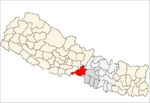
Bhandara, Nepal
| Bhandara भण्डारा, चितवन | |
|---|---|
 Bhandara Location in Nepal | |
| Coordinates: 27°36′N 84°39′E / 27.60°N 84.65°ECoordinates: 27°36′N 84°39′E / 27.60°N 84.65°E | |
| Country |
|
| Zone | Narayani Zone |
| District | Chitwan District |
| Government | |
| Population (1991) | |
| • Total | 10,424 |
| Time zone | UTC+5:45 (Nepal Time) |
| Postal Code | 44202 |
| Area code(s) | 056 |
Bhandara (Nepali :भण्डारा ; bhandara) lies in Eastern part of Chitwan District in the Narayani Zone of southern Nepal. It Is a ward of Rapti Municipality(Nepali : राप्ती नगरपालिका ), Formally Village development committee.
At the time of the 2012 Nepal census it had a population of 37, 424 people living in 3795 individual households.The city is blooming as a commercial hub for shopping and eateries. There are more than 25 resorts in and around the city which is fully equipped with essentials to ensure the better holiday place for the local as well as foreign tourist. With having more than 100 small and medium-sized restaurants and eateries, Bhandara is one of the best place to enjoy the authentic nepalese foods with Friends and family.
The location of this city is the best part for its tourism growth in recent years. It is situated below the mountain ranges and is a pure part of terai region. Ganesh Himal can be observed from this place. If you want to explore more you can take a roadtrip to Dhamili, which is situated at the top hill of Bhandara from where you can see the immense beauty of the hills as well as himalayas. [1]
Notable Places
- Nepal Fisheries Board, Bhandara
- Rapti River
- Tharu Village
- Gateway to Chitwan National Park
- Bandevi Mai Mandir, Shivapur
- Guru Gorakhnath Temple
- Uragyan Chhoiling Gumba
- Third Ladder Picnic Spot
- Dhamili
- Martal River Bridge
Hospitals
- Bhandara Health Post
- Family Healthcare
- Baba Jagadishwor Medicare
Schools
- Adarsha Vidhya Ashram
- Shangrila Academy
- Bhandara Higher Secondary School
- Darshan Academy
- Aama Montessori
- Shree Kashirupa Secondary School
Internet Service Providers
- Broadband Solutions Pvt. Ltd
See also
References
- ↑ "Nepal Census 2001". Nepal's Village Development Committees. Digital Himalaya. Archived from the original on 12 October 2008. Retrieved 14 December 2008.
