Berd, Armenia
Coordinates: 40°52′51″N 45°23′30″E / 40.88083°N 45.39167°E
| Berd Բերդ | |
|---|---|
.JPG) General view of Berd | |
 Berd Բերդ | |
| Coordinates: 40°52′51″N 45°23′30″E / 40.88083°N 45.39167°E | |
| Country |
|
| Marz | Tavush Province |
| Founded | 10th century |
| Area | |
| • Total | 3.5 km2 (1.4 sq mi) |
| Population (2011 census) | |
| • Total | 7,957 |
| • Density | 2,300/km2 (5,900/sq mi) |
| Time zone | UTC+4 (GMT) |
| Sources: Population[1] | |
Berd (Armenian: Բերդ), is a town and urban municipal community in the Tavush Province of Armenia. Formerly known as Berdagyugh, Gamma, Tavuzghala, Tauzkend, Tovuz, Volorut, Shlorut and Ghalakyand, it is located to the left of the Tavush river, 211 kilometres (131 miles) from Yerevan, surrounded with low mountains.
Located near the city are the ruins of the Tavush fortress (10th century), the Nor Varagavank and Khoranashat monasteries (12th century). Other monasteries not far include Shkhmuradi, Srveghi and Kaptavank.
Etymology
Berd literally means "fortress" in Armenian.
History
Historically, the area of modern-day Berd was part of the Tuchkatak canton of Utik; the 12th province of Greater Armenia.
Demographics
As of the 2011 census, the population of the town is 7,957.
The population are mainly Armenians. However the town is home to around 200 Udis who also belong to the Armenian Apostolic Church.
Economy
Berd and the surrounding areas are a major centre for agricultural products in Armenia. Fruits, tobacco and other types are produced in the surrounding farms. Other notable industries of Berd include wine-making, bee-keeping and granary.
Gallery
- Berd
 Tavush fortress
 Mashtots Avenue
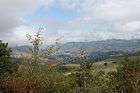 The town of Berd
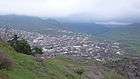 Berd landscape
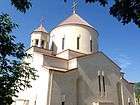 The church of Surp Hovhannes
References
| Wikimedia Commons has media related to Berd, Armenia. |
| Wikivoyage has a travel guide for Berd, Armenia. |
Capital: Ijevan | ||
| Urban communities | 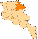 | |
| Rural communities |
| |
| Non-community settlements | ||
| Abandoned settlements | ||