Geghatap
Coordinates: 40°41′N 45°00′E / 40.683°N 45.000°E
| Geghatap Գեղատափ | |
|---|---|
 Geghatap | |
| Coordinates: 40°41′N 45°00′E / 40.683°N 45.000°E | |
| Country | Armenia |
| Marz (Province) | Tavush |
| Population (2017) | |
| • Total | 0 |
| Time zone | UTC+4 ( ) |
| • Summer (DST) | |
Geghatap (Armenian: Գեղատափ); formerly known as Chichakbulagh, is an abandoned village in the Tavush Province of Armenia. It was part of the Khachardzan rural community.
See also
References
- Report of the results of the 2001 Armenian Census, National Statistical Service of the Republic of Armenia
- Brady Kiesling, Rediscovering Armenia, p. 111; original archived at Archive.org, and current version online on Armeniapedia.org.
Capital: Ijevan | ||
| Urban communities | 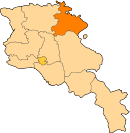 | |
| Rural communities |
| |
| Non-community settlements | ||
| Abandoned settlements | ||
This article is issued from
Wikipedia.
The text is licensed under Creative Commons - Attribution - Sharealike.
Additional terms may apply for the media files.