Getahovit
Coordinates: 40°53′45″N 45°07′53″E / 40.89583°N 45.13139°E
| Getahovit Գետահովիտ | |
|---|---|
 Getahovit | |
| Coordinates: 40°53′45″N 45°07′53″E / 40.89583°N 45.13139°E | |
| Country | Armenia |
| Marz (Province) | Tavush |
| Population (2011) | |
| • Total | 2,123 |
| Time zone | UTC+4 ( ) |
| • Summer (DST) | UTC+5 ( ) |
Getahovit (Armenian: Գետահովիտ; also Tala, Talakand) is a town in the Tavush Province of Armenia.
See also
References
- Getahovit at GEOnet Names Server
- World Gazeteer: Armenia – World-Gazetteer.com
- Report of the results of the 2001 Armenian Census, National Statistical Service of the Republic of Armenia
Capital: Ijevan | ||
| Urban communities | 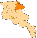 | |
| Rural communities |
| |
| Non-community settlements | ||
| Abandoned settlements | ||
This article is issued from
Wikipedia.
The text is licensed under Creative Commons - Attribution - Sharealike.
Additional terms may apply for the media files.