Benham Rise
| Benham Rise | |
|---|---|
|
Philippine Rise (Official Philippine name) Kalipung-awan (Catanduanon) | |
.svg.png) .svg.png) | |
| Location | Philippine Sea |
| Coordinates | 16°30′N 124°45′E / 16.500°N 124.750°ECoordinates: 16°30′N 124°45′E / 16.500°N 124.750°E |
| Designation | Protected food supply exclusive zone |
| Designated | May 2017 |
| Governing body | Philippine government (recognized by the United Nations since 2012) |
The Benham Rise, also known as the Philippine Rise, is a seismically active undersea region and extinct volcanic ridge located in the Philippine Sea approximately 250 km (160 mi) east of the northern coastline of Dinapigue, Isabela. The Rise has been known to the people of Catanduanes as Kalipung-awan since pre-colonial times, which literally means 'loneliness from an isolated place'.[1][2]
Under the Philippine Sea lie a number of basins including the West Philippine Sea Basin, inside of which is located the Central Basin Fault (CBF).[3] The Benham Plateau is located in the CBF and its basement probably is a micro-continent.[4] Several scientific surveys have been made on the feature to study its nature and its impact on tectonic subduction, including one about its effects on the 1990 Luzon earthquake. The Philippines claimed this feature as part of its continental shelf in a claim filed with the United Nations Commission on the Limits of the Continental Shelf on April 8, 2009, and which was approved under the United Nations Convention on the Law of the Sea (UNCLOS) in 2012.[5]
It is designated as a "protected food supply exclusive zone" by the Philippine government in May 2017. Mining and oil exploration is banned in the Benham Plateau as a protected area. On May 16, 2017, President Rodrigo Duterte signed Executive Order No. 25 renaming the feature to “Philippine Rise”,[6][7] and later allowed international vessels to conduct research on the Rise.
Geology
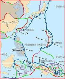
Benham Rise is a submerged extinct volcanic ridge located at 16 degrees 30 minutes N, 124 degrees 45 minutes E off the coast of Luzon, with the size of about 250 km in diameter and rises over 2,000 meters (2 km.) above the sea floor, from below 5,000 meters (5 km.) below sea level to above 3,000 meters (3 km.) below sea level. Its area is close to the Benham Seamount, located at 15 degrees 48 minutes N, 124 degrees 15 minutes E. The precise location is somewhere near the east of the Philippine Trench and near the south of the East Luzon Trench, both of which absorb the subducting force of the Philippine Sea Plate under the Philippine Mobile Belt,[8] a collage of large blocks of that crust that amalgamated prior to the collision of the Philippine Sea Plate with the Eurasian Plate.[9]
The origin of the landform, along with the nearby Urdaneta Plateau (a remnant of a mantle plume), is identified in one study as at least five sequences of propagating rifts, probably triggered by mantle flowing away from the mantle thermal anomaly.[10] Its presence of the landform disrupts the continuity of this region (known as the Philippine-East Luzon Trench) by continuously colliding with the Sierra Madre mountain range of eastern portion of the island of Luzon. Though it is generally thought that the Philippine Sea Plate is being subducted under the Philippine Mobile Belt, under the rules of tectonic subduction, there appears to be a resistance to this because of the presence of the landform, and instead, the plate is being displaced into the northern portion of Luzon to the west.[11][12]
The geophysical features of the plateau may have been the result of an early Miocene collision event between the Benham Rise and the eastern margin of Luzon, which may have also allowed the inception of the NW striking strand of the Philippine fault.[13] These forces may have impacted the shape of the island of Luzon because of the basaltic sea floor resisting the subduction that may have also cause the bending of the Philippine Fault.[14] The active basins in Central Luzon, which trace an asymmetrical V shape, is the best place to observe recent tectonic evolution of the fault system.
The Benham Bank is the shallowest point of the Benham Rise.
History
Survey by Admiral Benham
The landform was presumably named after Admiral Andrew Ellicot Kennedy Benham (1832–1905) by American surveyors who were the probable discoverers of the geological feature. He was a United States Navy officer, who served with both the South Atlantic and West Gulf Blockading Squadrons during the American Civil War.[15]
Studies following the 1990 Luzon earthquake
There has been speculation in the scientific community about the nature of the landform. Following the major 16 July 1990 Luzon earthquake, scientists reconsidered their fault models and decided it likely that Benham Plateau has similarly displaced the Philippine Fault System to the west.[16] After analysing older models such as that of Pinet and Stephan (1989), scientists reconsidered their fault models. They thought that it is highly likely that the Benham Plateau is still displacing Central Luzon and the Philippine Fault System to the west, which may have had an impact in causing such a catastrophic earthquake. The 20 second to 50 second wave in the 1990 quake that developed a new east-west sub-fault was so strong that it terminated disastrously at the city of Baguio in Benguet, Cordillera. Several scientific surveys, conducted between 2004 and 2008, collected hydrographic data that determined the morphology of the seabed in the region. Additional data from international bathymetric surveys and an analysis of international research projects were collected to support the findings.[17]
Philippine formal claim and 2012 UN recognition of claim
_NAMRIA_layout_2_May_24_2017.jpg)
Despite its proximity to the archipelago, the plateau was previously not included in the territory of the Philippines. On April 8, 2009, the Republic of the Philippines lodged a partial territorial waters claim with the United Nations Commission on the Limits of the Continental Shelf in relation to the continental shelf in the region of Benham Rise.[18] It was submitted as part of petition expanding the archipelago's baselines and exclusive economic zone through a law that also included other claims involving disputed territories of the Kalayaan Islands (Spratly Islands) and Scarborough Shoal. Although the landform, in itself, is not disputed, the petition still received some criticism from China.[19] According to the government's claim, based on a set of guidelines by the Commission on the Limits of the Continental Shelf, the area satisfies the 350-mile constraint line since the outer limits of the continental shelf are located landward of the constraint line, which is located 350 miles from the baselines where the measurement of the breadth of the territorial sea begins.[17]
The Congress of the Philippines enacted the bill of senator Miriam Defensor Santiago, now known as Republic Act No. 9522 or the Archipelagic Baselines Law, which is the basis of the claim. According to the document the region is bounded by the Philippine Basin on the north and east, and by Luzon on the west and south. It asserted that, according to scientific data based on seismic, magnetic, other geological features, the Benham Rise is an extension of the Philippines’ continental shelf. In summary, the baselines, the basis used for delineating the maritime territorial and jurisdictional zones (including the continental shelf), conform with the requirements of the UN Convention of the Law of the Sea (UNCLOS).[17] The claim is only a partial claim since the law that allows the Philippines to expand its territorial boundaries also includes islands in the South China Sea.
The Philippines filed its claim for Benham Rise in 2008 in compliance with the requirements of the [[United Nations Convention on the Law of the Seas. The UN officially approved the claim in April 2012, the first claim of the Philippines approved by an international body since the colonial era.[5][20][21][22] China released a statement saying that they do not recognize the ruling and that China seeks to claim the Benham Rise in the near future as it is part of a so-called 'Chinese second-chain islands'. However, there are no existing islands within the Benham Rise.
After Chinese survey ships were spotted in the region in 2017, Philippine president Rodrigo Duterte suggested that the plateau be renamed to emphasize the Philippine's sovereignty over the area. Soon after, the Department of Foreign Affairs announced plans to come up with a new name.[23] In May 2017, the Philippine government officially adopted the name "Philippine Rise" for the feature[7] and designated the area as a "protected food supply exclusive zone" and prohibited mining and oil exploration in the Benham Plateau, angering China in the process. China maintained that the Philippines has no sovereign rights or sovereignty over the Benham Rise despite a UN-backed international ruling in 2012 that says otherwise.[24]
Chinese research and naming of features in 2018
| In January 2018, the Chinese Institute of Oceanology of the Chinese Academy of Sciences conducted research in the Philippine territory of Benham Rise, with approval from foreign affairs secretary Alan Peter Cayetano and president Duterte. Despite the nature of the agreement, no document was signed by both parties. Additionally, the research was only made public via an opposition lawmaker. The research was never meant to be made public by Duterte. In February 12, 2018, after China submitted their research to UNESCO, the International Hydrographic Organization declared China's naming rights over five features in the Rise, sparking nationwide outrage. In February 18, it was revealed that China intends to name a total of 142 more features within the Rise.[25][26][27] |
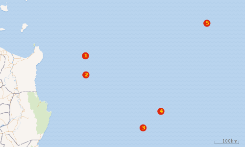 |
| Key:- 1 2 3 4 5 |
In January 2018, Filipino Congressman Gary Alejano revealed that Secretary Alan Peter Cayetano of the Department of Foreign Affairs had approved the Chinese Institute of Oceanology of the Chinese Academy of Sciences to perform a scientific survey of the Rise, with the approval of President Rodrigo Duterte.[28] Duterte's spokespreson, Harry Roque, later confirmed Alejano's revelation, and said that Filipinos have no capability to research the Rise. Backlash surged as numerous Filipino research proofs from university professors and researchers were leaked. In February, Duterte's agriculture secretary told media that Duterte has now ordered the halting of all foreign researches in the Philippines Rise, however, the research being conducted by the Chinese Academy of Sciences was already finished two days before the halt order.[29] Afterwards, confirmed reports broke out, stating that the International Hydrographic Organization (IHO) and the Intergovernmental Oceanographic Commission (IOC) of the UNESCO have rules wherein the entity that first discovers unnamed features underwater have the right to name those features, prompting Filipino officials to realize that China was after, not just research, but also the naming rights over the underwater features of the Benham Rise which will be internationally recognized through UNESCO.[30] A CSIS expert concluded that the current Philippine government is 'well-intentioned but naive'.[31] A few days after the research halt ordered by Duterte, it was clarified by the Philippine government that all researches ongoing at the time the halting was made were officially cancelled, but the government still fully allows research activities in the Rise after the halting. Foreign researchers, including Chinese, may still do research within the Rise if they apply for research activities through the Philippine government.[32] Due to this clarification, rallies surged in Philippine metropolitan streets. Duterte later insisted, in a bid to disperse public anxiety, that the Rise belongs to the Philippines.[33] February 12, 2018, the International Hydrographic Organization approved the names proposed by China for five features in the Benham Rise after China submitted to the organization its research findings on the area. The names given by China were all in Chinese, namely, Jinghao Seamount (some 70 nautical miles east of Cagayan), Tianbao Seamount (some 70 nautical miles east of Cagayan), Haidonquing Seamount (east at 190 nautical miles), Cuiqiao Hill, and Jujiu Seamount, the last two form the central peaks of the Benham Rise undersea geological province. The Chinese naming of the features met public protests in the Philippines, however, the Philippine government itself chose to impose a bystander policy, enlarging public anxiety towards the Duterte regime's buddy-buddy policy towards China.[27][34] Senator Bam Aquino protested the Chinese naming of the features and the inaction of the Duterte administration on the issue. In February 14, 2018, Philippine ambassador to the United Nations Teodoro Locsin Jr. defended China's naming of sea features within the Philippine Rise and tweeted that critics on the issue are 'childish and stupid', sparking a word war. Senate President Aquilino Pimentel III stated that he is 'not bothered' by the Chinese names and he sees no problems with the Chinese names given by China.[35] A few hours later, the Presidential Palace announced that it objects and it shall not recognize the Chinese names of the features and it will appeal for its rejection in the International Hydrographic Organization although Palace spokesperson noted that it will be hard to reject the already-internationally acknowledged names as the Philippines is not a member of the organization. On the other hand, China is a member of the organization. The Philippine government also said that their embassy in Beijing will coordinate with the Chinese regarding the issue.[36][37] A day later, the Palace announced that they intend to give Philippine names on the features of the Philippine Rise.[38] However, a few hours later, the presidential palace clarified that it has 'no problem' with the Chinese names in the Philippine Rise, citing that 'not all Chinese food with Chinese names belong to China, so not all sea features with Chinese names belong to it as well'.[39] Supreme Court Senior Justice Antonio Carpio, the foremost expert on Philippine sovereignty and sovereign rights, stated that the government should take bolder moves and conduct research on the Philippine Rise and establish internationally accepted names of the Rise's sea features to counter Chinese intrusions.[40] Opposition politicians condemned the passive attitude of the Duterte government on Filipino sovereignty and sovereign rights, while the presidential palace maintained its stand that it shall continue to exercise sovereign rights and if possible, naming rights over features in the Philippine Rise while maintaining a cordial relationship with China despite continuous Chinese intrusions. In February 16, the Duterte government sent a fraction of its military personnel into Cagayan Valley to 'chase away' Chinese warships in the Rise. The foreign affairs secretary cited the deployment as the 'largest deployment of Marines to Cagayan Valley,'.[41] In February 18, 2018, it was revealed that China, intends to name a total of 142 features within the coming months, where all proposed names shall be in native Chinese. The presidential palace stated that they are 'fine with it.'[42] In February 26, the Duterte government clarified during a Senate investigation that China actually surveyed the Rise without any Philippine-issued permit.[43] In May 15, Philippine president Duterte announced that he will go to the Philippine Rise 'riding a jetski' in a bid to calm speculations against the government's policy towards China, however, his son and special adviser later went instead and rode a jetski in the area. Photos of the event were circulated by the government online. In May 16, it was revealed that Duterte's son and special adviser did not rode a jetski in the Rise, instead they rode in Casiguran Bay of Casiguran, Aurora, a small body of water thousands of kilometers west from the Rise and enveloped by a landmass separating it from the Rise. The revelation sparked further outrage. Opposition leaders called the jetski event as nothing but government 'publicity stunt'.[44][45]
Cultural and strategic significance
Benham Rise has been part of the culture of ancient Filipinos. Ancient Catanduanes people have fished and roamed the area long before the colonial era. In fact, it is celebrated in Catandunganons' folktales, legends and poetry. Today, large percentage of fish caught by Catandunganon comes from Benham Rise. Its local Catandunganon term is called Kalipung-awan (means loneliness in an isolated place), as fisherfolks who catch marine life in the area for days often feel loneliness due to the area's vast waters which is seldom fished by other ethnic peoples aside from those living in Catanduanes. Its strategic location southeast of Taiwan, east of Luzon, and west of American territory of Guam make it a feature of geopolitical importance.[46]
In May 2017, the feature has been designated by the Philippines as a "protected food supply exclusive zone" prohibiting mining and oil exploration in the Benham Plateau.[24] To commemorate first anniversary of the Philippine government's renaming of the feature to "Philippine Rise", 500 square kilometers (190 sq mi) of the feature was declared a "Strict Protection Zone" exclusive for use for scientific research, while about 3,000 square kilometers (1,200 sq mi) of the marine area is designated as a Special Fisheries Management Area.[47]
References
- ↑ http://cnnphilippines.com/life/culture/2017/08/22/untranslatable-words.html
- ↑ http://newsinfo.inquirer.net/898607/duterte-renames-benham-rise-philippine-rise
- ↑ Hickey-Vargas, R.; Sato, H.; Machida, S.; Ishii, T.; Hirano, N.; Yumul, G.; Fujioka, K. "Isotopic Characteristics of Basalts From the Central Basin Fault, West Philippine Basin". Harvard University. Bibcode:2001AGUFM.T41C0893H.
Fall Meeting 2001
- ↑ Avijit Gupta. The physical geography of Southeast Asia (2005 ed.). Oxford University Press. p. 14. ISBN 0-19-924802-8. - Total pages: 440
- 1 2 "UN approves PH territorial claim to Benham Rise". Retrieved April 28, 2012.
- ↑ Viray, P.L. (22 May 2017). "Duterte renames 'Benham Rise' to 'Philippine Rise'". The Philippine Star. Retrieved 22 May 2017.
- 1 2 "Executive Order No. 25, s. 2017". www.gov.ph.
- ↑ Hashimoto, M, ed., (1981) Accretion Tectonics in the Circum-Pacific Regions, ISBN 90-277-1561-0 p299
- ↑ Rangin and Pubellier (1990) in Tectonics of Circum-Pacific Continental Margins ISBN 90-6764-132-4 p149
- ↑ Ryuichie, Shinjo; Ni Xianglonga; Wu Shiguoc (2008). "Tectonics in the Northwestern West Philippine Basin". Journal of China University of Geosciences. 19 (3): 191–199. doi:10.1016/S1002-0705(08)60038-2.
- ↑ Rangin and Pubellier (1990) in Tectonics of Circum-Pacific Continental Margins ISBN 90-6764-132-4, p149
- ↑ Deschamps and Lallemand (2003) in Intra-Oceanic Subduction Systems: Tectonic and Magmatic Processes ISBN 1-86239-147-5 p165
- ↑ Ringenbach, J. C.; N. Pinet; J. F. Stephan; J. Delteil (1993). "STRUCTURAL VARIETY AND TECTONIC EVOLUTION OF STRIKE-SLIP BASINS RELATED TO THE PHILIPPINE FAULT SYSTEM, NORTHERN LUZON, PHILIPPINES". Tectonics. 12 (1): 187–203. Bibcode:1993Tecto..12..187R. doi:10.1029/92TC01968. Retrieved September 27, 2009.
- ↑ Rantucci, Giovanni (Oct 1994). "Geological disasters in the Philippines : The July 1990 earthquake and the June 1991 eruption of Mount Pinatubo". United Nations. ISDR. Retrieved September 27, 2009. , Document ID:13258
- ↑ "Benham One-Name Study". Guild of One-Name Studies. 8 Mar 2008. Retrieved September 27, 2009.
- ↑ Pinet and Stephan (1989) in Tectonics of Circum-Pacific Continental Margins ISBN 90-6764-132-4 p.179
- 1 2 3 Tessa Jamandre (12 April 2009). "RP files claim over Benham Rise with UN". verafiles.org. Archived from the original on April 26, 2009. Retrieved September 27, 2009.
- ↑ "Submissions, through the Secretary-General of the United Nations, to the Commission on the Limits of the Continental Shelf, pursuant to article 76, paragraph 8, of the United Nations Convention on the Law of the Sea of 10 December 1982". United Nations Commission on the Limits of the Continental Shelf. 28 May 2009. Retrieved 29 May 2009.
- ↑ Ellen Tordesillas (March 25, 2008). "RP in last minute scramble to beat UN deadline". ellentordesillas.com. Retrieved September 27, 2009.
- ↑ UN to decide on Phl claim on 13-M hectare Benham Rise, August 16, 2011, Philippine Star.
- ↑ UN approves PH territorial claim to Benham Rise, April 28, 2012, Philippine Daily Inquirer.
- ↑ DOE to assess resource potential of Benham Rise:http://www.philstar.com/headlines/2014/06/09/1332626/doe-assess-resource-potential-benham-rise
- ↑ Staff (April 2, 2017). "Duterte wants to rename Benham Rise". Filipino Times. Retrieved April 2, 2017.
- 1 2 Santos, Eimor (12 May 2017). "Benham Rise is now Philippine Rise, and a protected food supply zone – Piñol". CNN Philippines. Retrieved 13 May 2017.
- ↑ https://www.philstar.com/headlines/2018/02/18/1788981/china-wants-name-142-ocean-features
- ↑ https://www.philstar.com/headlines/2018/02/08/1785645/china-seeks-name-sea-features-philippine-rise
- 1 2 http://news.abs-cbn.com/focus/02/12/18/china-named-5-undersea-features-at-ph-rise-says-expert
- ↑ Amurao, George (January 18, 2018). "China eyes Philippines' strategic eastern shores". Asia Times.
- ↑ http://www.gmanetwork.com/news/news/nation/642291/duterte-orders-no-more-foreign-explorations-in-benham-rise-pinol/story/
- ↑ https://beta.philstar.com/headlines/2018/02/08/1785645/china-seeks-name-sea-features-philippine-rise
- ↑ https://www.rappler.com/nation/195587-duterte-naive-west-philippine-sea-gregory-poling-csis
- ↑ http://www.sunstar.com.ph/manila/local-news/2018/02/06/palace-clarifies-foreign-research-may-be-allowed-philippine-rise-587568
- ↑ http://www.sunstar.com.ph/manila/local-news/2018/02/10/philippine-rise-belongs-philippines-duterte-insists-588240
- ↑ http://globalnation.inquirer.net/164127/breaking-china-named-5-undersea-features-ph-rise-expert
- ↑ http://globalnation.inquirer.net/164167/pimentel-sees-no-problem-chinas-benham-naming
- ↑ https://www.rappler.com/nation/196018-philippines-rejects-chinese-names-benham-rise-features
- ↑ http://cnnphilippines.com/news/2018/02/14/Philippines-wont-recognize-Chinese-names-of-Benham-Rise-features.html
- ↑ http://cnnphilippines.com/news/2018/02/15/benham-rise-features-philippines-name-harry-roque.html
- ↑ http://globalnation.inquirer.net/164266/chinese-names-ph-rise-no-problem-says-palace
- ↑ http://malaya.com.ph/business-news/news/carpio-ph-should-name-philippine-rise-features-pronto
- ↑ http://news.abs-cbn.com/news/02/16/18/govt-deploys-troops-to-guard-philippine-rise
- ↑ https://beta.philstar.com/headlines/2018/02/18/1788981/china-wants-name-142-ocean-features
- ↑ https://www.rappler.com/nation/196933-senate-hearing-benham-rise
- ↑ https://www.philstar.com/headlines/2018/05/16/1815775/critics-hit-benham-rise-publicity-stunt-casiguran
- ↑ https://www.rappler.com/newsbreak/fact-check/202832-bong-go-philippine-flag-benham-rise
- ↑ Stashwick, Steven (March 31, 2017). "China May Have Been Surveying Strategic Waters East of Philippines". The Diplomat. Retrieved March 31, 2017.
The Benham Rise is directly south of the eastern approaches to the Luzon Strait between Taiwan and the Philippines, which is the main access route from the Western Pacific Ocean to the South China Sea. In a conflict, control of that strait would dictate whether China’s South Sea Fleet could “break out” of the South China Sea into the Western Pacific to the waters between the first and second island chains, or if the U.S. Navy could move forces into the South China Sea to conduct its own combat operations.
- ↑ Lopez, Virgil (15 May 2018). "Duterte declares parts of Benham Rise a marine protected area". GMA News. Retrieved 16 May 2018.
External links
Geography of the Philippines | ||
|---|---|---|
| Geology |  | |
| Landforms |
| |
| Water | ||
| Seas | ||
| Environment |
| |