Khirbet Beit Zakariyyah
| Khirbet Beit Zakariyyah | |
|---|---|
| Other transcription(s) | |
| • Also spelled | Khallet Sakarya (unofficial) |
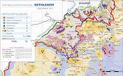 Area map showing Khallet Sakariya, 2011 | |
 Khirbet Beit Zakariyyah Location of Khirbet Beit Zakariyyah within Palestine | |
| Coordinates: 31°39′47″N 35°07′24″E / 31.66306°N 35.12333°ECoordinates: 31°39′47″N 35°07′24″E / 31.66306°N 35.12333°E | |
| Palestine grid | 160/118 |
| Governorate | Bethlehem |
| Government | |
| • Type | Village council |
| Elevation[1] | 950 m (3,120 ft) |
| Name meaning | Khurbet Beit Skâria; The ruin of Beit Skaria (the ancient Beth Zacharias)[2] |
Khirbet Beit Zakariyyah (variants: Beit Zakariyyah, Khirbet Zakariah, Beit Skâria) is a small Palestinian village in the West Bank. It is located in between the larger Israeli settlements of Alon Shevut and Rosh Tzurim in the Gush Etzion region. Administratively, it is associated with Artas, Bethlehem.
Location
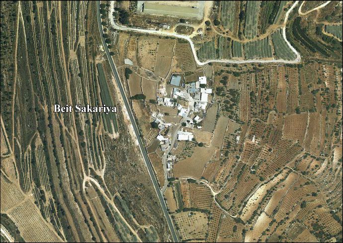
Khirbet Beit Zakariyyah is located 9 kilometers (5.6 mi) (horizontal distance) south of Bethlehem. It is bordered by Wadi an Nis to the east, Nahhalin to the north, Al Jab’a to the west, and Beit ‘Ummar and Surif to the south.[1]
History
The village may be the site of the Battle of Beth Zechariah between the Jewish Maccabeans and Selucid Greek forces during the Maccabean revolt against the Seleucid Empire, in the year 162 BCE.[3][4][5] However, other sources place the battle at Zekharia/Az-Zakariyya in modern Israel.[6]
Three rock-cut burial caves, dating to the 1st century BCE have been excavated, and pottery fragments from the 1st century BCE were found.[7]
In the Byzantine period an important church was located here, which appears on the Madaba map. Since then a mosque, going by the name Nabi-Zakariah, has been built on the site of the church. Some of the ruins of the church are preserved beneath the mosque. In general, houses in the village are built on top of ancient ruins and caves.
During the Crusader era, Casale Zacharie, like nearby al-Khidr, probably was a Christian village, and it was granted with al-Khidr to the church of Bethlehem between c. 1155 and c. 1186.[8]
Pottery fragments from the Mamluk era have also been found.[7]
Ottoman era
In the Ottoman census of 1538-1539, Bayt Dhakariyya was located in the nahiya of Halil,[9] while in 1557, it was noted that the village revenues went to an Imperial imaret in Jerusalem.[10]
In 1852, Edward Robinson noted Beit Sakarieh “on an almost isolated promontory or Tell, jutting out northwest between two deep valleys; and connected with the high ground south by a low neck between the heads of those two valleys."[11]
An Ottoman list from about 1870 notes a Muslim wali, dedicated to a Sheikh Zakarja, located under a large tree. Several cisterns were also noted, and that the old Roman road to Jerusalem passed by.[12]
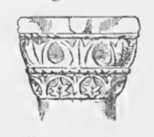
The Palestine Exploration Fund's Survey of Western Palestine visited in 1873 and noted: "From the main Roman road on the south a path leads to this ruin, situate on the brow, overlooking deep valleys on the east and north. Beside the path is a square foundation about 50 feet side, of roughly-dressed stones. The remains on the hill-brow are those of a large modern village, with more ancient foundations. One wall consists of stones 4 1/2 feet long, 2 feet high, roughly dressed. There is also a mosque, with a portico on the west, sunk below the surface. On the north side of this portico a pillar is placed with a capital of basket-work (see illustration), like the eighth century Byzantine capitals. The shaft is 2 feet diameter. The mosque door was shut ; perhaps it may represent the site of the church which once stood at this place. [..] Drafted stones with a rough boss were also found, and another capital, apparently Byzantine. To the west of the site are rock-cut tombs, now blocked. A tree grows over the Mukam, or mosque."[13]
1948
On January 14, 1948, Arab forces led by Abd al-Qadir al-Husayni attempted to capture the strategic hill of Beit Zakariah, and thus to split Gush Etzion into two in preparation for its total conquest. However, Jewish forces defeated them in the Battle of 3 Shevat. The defeat had strategic implications for all of Palestine - as a result, Husseini cancelled his plans to attack Jewish communities, and focused on attacks on the roads.[14][15]
Jordanian era
In the wake of the 1948 Arab–Israeli War, and after the 1949 Armistice Agreements, Khirbet Beit Zakariyyah came under Jordanian rule.
1967-present
Since the Six-Day War in 1967, Khirbet Beit Zakariyyah has been under Israeli occupation.[16]
After the Oslo Accords in 1995, 100% of Khirbet Beit Zakariyyah land was classified as Area C, under full Israeli control.[17]
Israel has confiscated land from Khirbet Beit Zakariyyah in order to construct six Israeli settlements:
- 45 dunams were taken for Efrat[18]
- 780 dunams for Rosh Zurim[18]
- 920 dunams for Allon Shevut[18]
- 41 dunams for Migdal Oz[18]
- 420 dunams for Kfar Etzion[18]
- 144 dunams for Bat Ayin[18]
References
- 1 2 Beit Sakariya Village Profile, ARIJ, p. 4
- ↑ Palmer, 1881, p. 302
- ↑ Schürer, Millar, and Vermes, 2014, p. 166
- ↑ Beth-zacharias, International Standard Bible Encyclopedia
- ↑ Claude R. Conder, Tent Work in Palestine (vol. 1), London 1879, p. 279
- ↑ French explorer Victor Guérin thought Tell Zakariyeh (where now stands Azekah, in Israel), to be the village mentioned in the Book of I Maccabees (6:32), known then as Beit Zakariah, and which stood "seventy stadia" from Beit Sour, a distance of almost thirteen kilometers. See: Guérin, 1869, pp. 316-319
- 1 2 Peleg and Feller, 2004, Rosh Zurim
- ↑ Pringle, 1993, p. 204
- ↑ Toledano, 1984, p. 289, has Bayt Dhakariyya at location 35°07′00″E 31°40′05″N.
- ↑ Singer, 1994, pp. 26, note #6; 165
- ↑ Robinson and Smith, 1856, pp. 283-284
- ↑ Socin, 1879, p. 148
- 1 2 Conder and Kitchener, 1883, SWP III, p. 108
- ↑ http://www.news1.co.il/Archive/002-D-109259-00.html
- ↑ Yohanan Ben-Yaakov, The Mountain Division, the Lamed-Heh Story, Israel Defence Ministry press, 2008, page 44
- ↑ Aharon Dolev, Rosh Tzurim: the petition was denied, Maariv, 7 November 1980
- ↑ Beit Sakariya Village Profile, ARIJ, p. 16
- 1 2 3 4 5 6 Beit Sakariya Village Profile, ARIJ, p. 17
Bibliography
- Conder, C.R.; Kitchener, H. H. (1883). The Survey of Western Palestine: Memoirs of the Topography, Orography, Hydrography, and Archaeology. 3. London: Committee of the Palestine Exploration Fund.
- Guérin, V. (1869). Description Géographique Historique et Archéologique de la Palestine (in French). 1: Judee, pt. 3. Paris: L'Imprimerie Nationale.
- Palmer, E. H. (1881). The Survey of Western Palestine: Arabic and English Name Lists Collected During the Survey by Lieutenants Conder and Kitchener, R. E. Transliterated and Explained by E.H. Palmer. Committee of the Palestine Exploration Fund.
- Peleg, Yuval; Feller, Yaron (2004-05-31). "Rosh Zurim" (116). Hadashot Arkheologiyot – Excavations and Surveys in Israel.
- Pringle, Denys (1993). The Churches of the Crusader Kingdom of Jerusalem: A-K (excluding Acre and Jerusalem). I. Cambridge University Press. ISBN 0 521 39036 2.
- Robinson, E.; Smith, E. (1856). Later Biblical Researches in Palestine and adjacent regions: A Journal of Travels in the year 1852. London: John Murray.
- Schürer, E.; Millar, F.; Vermes, G. (2014). The History of the Jewish People in the Age of Jesus Christ. A&C Black. ISBN 1472558278.
- Singer, Amy (1994). Palestinian Peasants and Ottoman Officials: Rural Administration Around Sixteenth-Century Jerusalem. Cambridge University Press. ISBN 9780521476799.
- Socin, A. (1879). "Alphabetisches Verzeichniss von Ortschaften des Paschalik Jerusalem". Zeitschrift des Deutschen Palästina-Vereins. 2: 135–163.
- Toledano, E. (1984). "The Sanjaq of Jerusalem in the Sixteenth Century: Aspects of Topography and Population". Archivum Ottomanicum. 9: 279–319.
- van de Velde, C.W.M. (1858). Memoir to Accompany the Map of the Holy Land. Gotha: Justus Perthes. (p. 166)
External links
- Survey of Western Palestine, Map 17: IAA, Wikimedia commons
- Beit Sakariya Village (Fact Sheet), Applied Research Institute–Jerusalem, (ARIJ)
- Beit Sakariya Village Profile, ARIJ
- Beit Sakariya aerial photo, ARIJ
- The priorities and needs for development in Beit Sakariya village based on the community and local authorities’ assessment), ARIJ
- Land Grab continues in Bethlehem District, posted: 09/03/04, POICA
- Threats of House Demolitions in Beit Sakariya Hamlet, 10/04/2007, POICA
- When Settlers Attack, Thejerusalemfund
| Cities |  | |
|---|---|---|
| Municipalities | ||
| Villages |
| |
| Refugee camps | ||
| Other | ||