al-Ubeidiya
| al 'Ubeidiya | |
|---|---|
| Other transcription(s) | |
| • Arabic | لعبيديّه |
| • Also spelled |
al-Obaidya (official) Deir Dosi[1] (unofficial) |
 | |
 al 'Ubeidiya Location of al 'Ubeidiya within Palestine | |
| Coordinates: 31°43′24″N 35°17′26″E / 31.72333°N 35.29056°ECoordinates: 31°43′24″N 35°17′26″E / 31.72333°N 35.29056°E | |
| Palestine grid | 177/125 |
| Governorate | Bethlehem |
| Government | |
| • Type | Municipality |
| Area | |
| • Jurisdiction | 97,232 dunams (97.2 km2 or 37.5 sq mi) |
| Population (2007) | |
| • Jurisdiction | 10,753 |
| Name meaning | 1881: Kh. Deir Ibn Obeid, meaning "The ruin of the monastery of the son of Obeid; also called Mar Theodosius[2] |
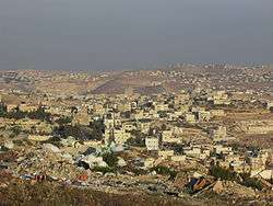
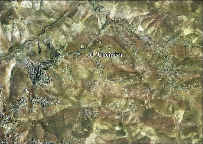
Al-Ubeidiya (Arabic: لعبيديّه) is a Palestinian town located 6 kilometers (3.7 mi) east of Bethlehem. The town is a part of the Bethlehem Governorate in the central West Bank. According to the Palestinian Central Bureau of Statistics (PCBS), al-Ubeidiya had a population of over 10,753 in 2007.[3]
History and archaeology
Al-Ubeidiya is named after Saint Theodosius ("Ibn Ubeid" in Arabic), who built and was buried in a monastery 1 kilometer (0.62 mi) west of the town, known as the Monastery of St. Theodosius. It was originally constructed in the 5th-century CE and Theodosius was buried there in 520. The current structure was built by the Crusaders in the 12th-century. It is located on a hilltop and is under the administration of the Greek Orthodox Church. The Mar Saba Monastery—which was built by Saint Sabbas in 484 CE—is located further east of the town center, but within its municipal jurisdiction. An Ancient Roman pool is situated in the center of al-Ubeidiya and was used in the Roman era of rule in Palestine to collect water.[4] According to Dauphin, most of current the Monastery dates from the 19th century, but incorporates Byzantine remains.[5]
Ottoman era
The area, like the rest of Palestine, was incorporated into the Ottoman Empire in 1517. In 1596 Al-Ubeidiya appeared in Ottoman tax registers, called Dayr Bani 'Ubayd, being in the nahiya of Al-Quds in the liwa of Al-Quds. It had a population of 42 households and 6 bachelors, all Muslim. They paid a fixed tax-rate of 33,3 % on agricultural products, including wheat, barley, occasional revenues, goats and/or beehives; a total of 4,900 Akçe.[6] According to local tradition, the modern town of al-Ubeidiya was founded when members of the Shammar tribe from the Arabian Peninsula settled there, and it was not named after St. Theodosius, but after tribal leader, al-Ubeidi Faris.[4]
Around 1740 Richard Pococke noted "We soon came to a ruin called Der Benalbede, which from the name seems to have been an old convent."[7]
In 1838, Edward Robinson noted Deir ibn Obeid, not far from Mar Saba, on his travels in the region.[8][9]
In 1863, the French explorer Victor Guérin visited the place, which he called Deir Dosi, and described the remains of the monastery.[1] In 1883, the Palestine Exploration Fund's Survey of Western Palestine described there Kh. Deir Ibn Obeid as "Ruins of a modern village",[10] but in 1899 Conrad Schick noted that "This [] designation is not sufficient -the ruins are not those of a village, but of a former convent, and only in the modern times used as a storehouse for grain for the wandering tribe Ubedieh."[11]
British Mandate era
In the 1922 census of Palestine, conducted by the British Mandate authorities, the tribal area of Ibaidiyeh had an all Muslim population of 2,000, 880 males and 1,120 females.[12] In the 1931 census the El Ubeidiya consisted of 1,187 persons, still all Muslim, 610 males and 577 females.[13]
In 1945 the population was counted under the name of tribal unit Arab Ibn Ubeid, together with Arab et Ta'amira, Arab et Rashayida and Arab et Sawahira; together they had a population of 7,070 Muslims,[14], where Arab Ibn Ubeid had a total of 92,026 dunams of land according to an official land and population survey.[15] Of this, 3,732 dunams were used for cereals,[16] while 88,294 dunams were classified as non-cultitivable land.[17]
Jordanian era
In the wake of the 1948 Arab–Israeli War, and after the 1949 Armistice Agreements, Al-Ubeidiya came under Jordanian rule.
In 1961, the population of 'Ubeidiya was 838.[18]
1967, aftermath
Since the Six-Day War in 1967, al-Ubeidiya has been under Israeli occupation. The population in the 1967 census conducted by the Israeli authorities was 1,377.[19]
After 1995, 9.1 % of village land is defined as Area A land, 0.4 % as Area B, and the remainder 82 % as Area C.[20] Israel has confiscated land from Al-Ubeidiya in order to construct Israeli settlements; 124 dunams were taken for the construction Avenat, while 97 dunams were taken for ‘Ayn Fashkhah.[21]
Since 1997, al-Ubeidiya has been governed by an 11-member municipal council appointed by the Palestinian National Authority (PNA). The municipality has jurisdiction over 97,232 dunams of land—much larger than the built-up and residential areas of the town which constitute 979 of those dunams. Other localities located within the municipal borders include Wadi al-Arayis.[4]
The residents are mostly descendants of the Shammar with the main families being al-'Asa, al-Radayda, al-Rabai'a, al-Hasasna, and Abu Sirhan. The population is Muslim (although the monasteries are populated by Greek Orthodox monks) and there are ten mosques in the town.[4]
References
- 1 2 Guérin, 1869 pp. 88 -92
- ↑ Palmer, 1881, p. 303
- ↑ 2007 PCBS Census Palestinian Central Bureau of Statistics. p.118.
- 1 2 3 4 Al ‘Ubeidiya Town Profile. Applied Research Institute–Jerusalem. 2010.
- ↑ Dauphin, 1998, p. 913
- ↑ Hütteroth and Abdulfattah, 1977, p. 114.
- ↑ Pococke, 1745, vol 2, p. 34, cited in Robinson and Smith, 1841, vol 2, p. 159
- ↑ Robinson and Smith, 1841, vol 2, p. 159
- ↑ Robinson and Smith, 1841, vol 3, 2nd appendix, p. 123
- ↑ Conder and Kitchener, 1883, p. 111
- ↑ Schick, 1899, pp. 36-37
- ↑ Barron, 1923, Table VII, Sub-district of Bethlehem, p. 18
- ↑ Mills, 1932, p. 36
- ↑ Government of Palestine, Department of Statistics, 1945, p. 25
- ↑ Government of Palestine, Department of Statistics. Village Statistics, April, 1945. Quoted in Hadawi, 1970, p. 58
- ↑ Government of Palestine, Department of Statistics. Village Statistics, April, 1945. Quoted in Hadawi, 1970, p. 104
- ↑ Government of Palestine, Department of Statistics. Village Statistics, April, 1945. Quoted in Hadawi, 1970, p. 154
- ↑ Government of Jordan, Department of Statistics, 1964, p. 23
- ↑ Perlmann, Joel (November 2011 – February 2012). "The 1967 Census of the West Bank and Gaza Strip: A Digitized Version" (PDF). Levy Economics Institute. Retrieved 24 June 2016.
- ↑ Al ‘Ubeidiya Town Profile, ARIJ, p. 18
- ↑ Al ‘Ubeidiya Town Profile, ARIJ, p. 19
Bibliography
- Barron, J. B., ed. (1923). Palestine: Report and General Abstracts of the Census of 1922. Government of Palestine.
- Conder, C.R.; Kitchener, H. H. (1883). The Survey of Western Palestine: Memoirs of the Topography, Orography, Hydrography, and Archaeology. 3. London: Committee of the Palestine Exploration Fund.
- Dauphin, Claudine (1998). La Palestine byzantine, Peuplement et Populations. BAR International Series 726 (in French). III : Catalogue. Oxford: Archeopress. ISBN 0-860549-05-4.
- Government of Jordan, Department of Statistics (1964). First Census of Population and Housing. Volume I: Final Tables; General Characteristics of the Population (PDF).
- Government of Palestine, Department of Statistics (1945). Village Statistics, April, 1945.
- Guérin, V, (1869). Description Géographique Historique et Archéologique de la Palestine (in French). 1: Judee, pt. 3. Paris: L'Imprimerie Nationale.
- Hadawi, S. (1970). Village Statistics of 1945: A Classification of Land and Area ownership in Palestine. Palestine Liberation Organization Research Center.
- Hütteroth, Wolf-Dieter; Abdulfattah, Kamal (1977). Historical Geography of Palestine, Transjordan and Southern Syria in the Late 16th Century. Erlanger Geographische Arbeiten, Sonderband 5. Erlangen, Germany: Vorstand der Fränkischen Geographischen Gesellschaft. ISBN 3-920405-41-2.
- Marti, K.; Schick, C (1880). "Mitteilungen von Bauart C. Schick in Jerusalem über die alten Lauren und Klöster in der Wüste Juda". Zeitschrift des Deutschen Palästina-Vereins. 3: 1–43. (Marti and Schick, 1880, pp. 34-37)
- Mills, E., ed. (1932). Census of Palestine 1931. Population of Villages, Towns and Administrative Areas. Jerusalem: Government of Palestine.
- Palmer, E. H. (1881). The Survey of Western Palestine: Arabic and English Name Lists Collected During the Survey by Lieutenants Conder and Kitchener, R. E. Transliterated and Explained by E.H. Palmer. Committee of the Palestine Exploration Fund.
- Pococke, R. (1745). A description of the East, and some other countries. 2. London: Printed for the author, by W. Bowyer.
- Pringle, Denys (1998). The Churches of the Crusader Kingdom of Jerusalem: L-Z (excluding Tyre). II. Cambridge University Press. ISBN 0 521 39037 0. (pp. 271-278)
- Robinson, E.; Smith, E. (1841). Biblical Researches in Palestine, Mount Sinai and Arabia Petraea: A Journal of Travels in the year 1838. 2. Boston: Crocker & Brewster.
- Robinson, E.; Smith, E. (1841). Biblical Researches in Palestine, Mount Sinai and Arabia Petraea: A Journal of Travels in the year 1838. 3. Boston: Crocker & Brewster.
- Schick, C. (1899). "Reports by Dr. Conrad Schick". Quarterly statement - Palestine Exploration Fund. 31: 36-37.
External links
- Survey of Western Palestine, Map 17: IAA, Wikimedia commons
- Al-‘Ubeidiya Town (Fact Sheet), Applied Research Institute–Jerusalem (ARIJ)
- Al ‘Ubeidiya Town Profile, ARIJ
- Al-‘Ubeidiya Aerial Photo, ARIJ
- The priorities and needs for development in Al ‘Ubeidiya town based on the community and local authorities’ assessment, ARIJ
| Cities |  | |
|---|---|---|
| Municipalities | ||
| Villages |
| |
| Refugee camps | ||
| Other | ||