Rosh Tzurim
| Rosh Tzurim | |
|---|---|
 | |
 Rosh Tzurim | |
| Coordinates: 31°40′1.49″N 35°7′32.5″E / 31.6670806°N 35.125694°ECoordinates: 31°40′1.49″N 35°7′32.5″E / 31.6670806°N 35.125694°E | |
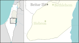
| District | Judea and Samaria Area |
| Council | Gush Etzion |
| Region | West Bank |
| Affiliation | Religious Kibbutz Movement |
| Founded | 1969 |
| Founded by | Bnei Akiva Religious Scouts and Nahal |
| Population (2017)[1] | 934 |
| Website | r-tzurim.co.il |
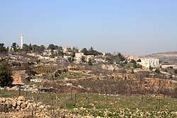
Rosh Tzurim (Hebrew: רֹאשׁ צוּרִים, eng. Top of the Rocks) is an Israeli settlement and religious kibbutz in the West Bank established in 1969. It is located about 20 kilometers (12 mi) south of Jerusalem, 3.9 km east of the Green Line, inside of the Separation Barrier. A member of the Religious Kibbutz Movement, it falls under the jurisdiction of the Gush Etzion Regional Council. In 2017 it had a population of 934.
The international community considers Israeli settlements in the West Bank illegal under international law, but the Israeli government disputes this.[2]
History
According to ARIJ, Israel confiscated land from two nearby Palestinian villages in order to construct Rosh Tzurim: 110 dunams of land were taken from Nahalin,[3] while 780 dunams of land were taken from Khirbet Beit Zakariyyah.[4]
The settlement was established in 1969 by members of Bnei Akiva Religious Scouts and Nahal soldiers. The Name originates from the Biblical passage "For from the top of the mountains I see him" (Num 23:9)[5] - just like the neighbouring village Gevaot.
Rosh Tzurim is located on the site of the ancient Beth Zechariah and on a hilltop that had previously been occupied by Ein Tzurim, a kibbutz that was destroyed in the 1948 Arab-Israeli War by the Jordanian Arab Legion and later re-established in the Lakhish area.
Rosh Tzurim went through a privatization process, first through the rental of available houses, and later an additional neighborhood, Nof Tzurim, was built on the kibbutz.[6]
Economy
The kibbutz raises turkeys, produces milk and grows grapes for wine production along with other fruits.
References
- ↑ "List of localities, in Alphabetical order" (PDF). Israel Central Bureau of Statistics. Retrieved August 26, 2018.
- ↑ "The Geneva Convention". BBC News. 10 December 2009. Retrieved 27 November 2010.
- ↑ Nahhalin Village Profile, ARIJ, p. 18
- ↑ Beit Sakariya Village Profile, ARIJ, p. 17
- ↑ Carta's Official Guide to Israel and Complete Gazetteer to all Sites in the Holy Land. (3rd edition 1993) Jerusalem, Carta, p.403 , ISBN 965-220-186-3 (English)
- ↑ "Rash Tzurim". Gush Etzion Foundation. Retrieved 16 April 2013.