Bapatla mandal
| Bapatla mandal | |
|---|---|
| Mandal | |
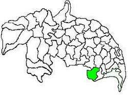 Mandal map of Guntur district showing Bapatla mandal (in green) | |
 Bapatla mandal Location in Andhra Pradesh, India | |
| Coordinates: 15°53′20″N 80°28′12″E / 15.88889°N 80.47000°ECoordinates: 15°53′20″N 80°28′12″E / 15.88889°N 80.47000°E | |
| Country | India |
| State | Andhra Pradesh |
| District | Guntur |
| Headquarters | Bapatla |
| Government | |
| • Body | Mandal Parishad |
| • Tehsildar | T.Valliah |
| Area[1] | |
| • Total | 233.91 km2 (90.31 sq mi) |
| Population (2011)[2] | |
| • Total | 143,825 |
| • Density | 610/km2 (1,600/sq mi) |
| Languages | |
| • Official | Telugu |
| Time zone | UTC+5:30 (IST) |
Bapatla mandal is one of the 57 mandals in Guntur district of the state of Andhra Pradesh, India. It is under the administration of Tenali revenue division and the headquarters are located at Bapatla town.[3][1] The mandal is bounded by Kakumanu, Ponnur, Karlapalem mandals of Guntur district. It also shares borders with Prakasam district and a portion of it lies on the coast of Bay of Bengal.[4]
Demographics
As of 2011 census, the mandal had a population of 143,825. The total population constitute, 70,847 males and 72,978 females —a sex ratio of 1030 females per 1000 males. 13,371 children are in the age group of 0–6 years, of which 6,856 are boys and 6,515 are girls. The average literacy rate stands at 71.79% with 93,653 literates.[2]
Towns and villages
As of 2011 census, the mandal has 21 settlements. It includes 20 villages and 1 town of Bapatla.[3][5]
The settlements in the mandal are listed below:
- Adivi
- Appikatla
- Bapatla (M)
- Bapatla East (Rural)
- Bapatla West (Rural)
- Bharthipudi
- Cheruvu
- ETHERU
- Gopapuram
- Gudipudi
- Jammulapalem
- Jillellamudi
- Kankatapalem
- Maruproluvaripalem (Rural)
- Mulapalem
- Murukondapadu
- Narasayapalem
- Neredupalle
- Palaparthipadu
- Poondla
- Velicherla
Note: M-Municipality[6]
Government and politics
The mandal is under the control of a tahsildar and the present tahsildar is T.Valliah.[7] Bapatla mandal is one of the 3 mandals under Bapatla (Assembly constituency), which in turn represents Bapatla (SC) (Lok Sabha constituency) of Andhra Pradesh.[8]
Education
The mandal plays a major role in education for the rural students of the nearby villages.The primary and secondary school education is imparted by government, aided and private schools, under the School Education Department of the state.[9] As per the school information report for the academic year 2015–16, the mandal has more than 22,103 students enrolled in over 157 schools.[10][11]
See also
References
- 1 2 "District Census Handbook - Guntur" (PDF). Census of India. pp. 14, 498. Retrieved 5 July 2016.
- 1 2 "Census 2011". The Registrar General & Census Commissioner, India. Archived from the original on 23 September 2015. Retrieved 16 October 2014.
- 1 2 "Guntur District Mandals" (PDF). Census of India. pp. 102, 112. Retrieved 19 January 2015.
- ↑ "Mandals in Guntur district". aponline.gov.in. Archived from the original on 28 April 2015. Retrieved 10 September 2014.
- ↑ "Sub-District Details of Guntur District". The Registrar General & Census Commissioner, India. Retrieved 10 September 2014.
- ↑ "Abbreviations used". censusindia.gov.in. Archived from the original on 17 June 2007. Retrieved 26 May 2014.
- ↑ "List of Tahsildars working in Guntur District as on 19.06.2014" (PDF). Guntur District Official Website. National Informatics Centre. p. 1. Retrieved 8 September 2014.
- ↑ "Delimitation of Parliamentary and Assembly Constituencies Order, 2008" (pdf). Election Commission of India. p. 22. Retrieved 11 October 2014.
- ↑ "School Education Department" (PDF). School Education Department, Government of Andhra Pradesh. Archived from the original (PDF) on 27 December 2015. Retrieved 7 November 2016.
- ↑ "R1.1 SCHOOL INFORMATION". Archived from the original on 2016-11-08.
- ↑ "Student Information Report". Commissionerate of School Education. Child info 2015-16, District School Education - Andhra Pradesh. Retrieved 8 November 2016.
Places adjacent to Bapatla mandal | ||||||||||
|---|---|---|---|---|---|---|---|---|---|---|
| ||||||||||