Bátonyterenye District
| Bátonyterenye District Bátonyterenyei járás | |||
|---|---|---|---|
| Districts of Hungary | |||
| |||
 Bátonyterenye District within Hungary and Nógrád County. | |||
| Country |
| ||
| County | Nógrád | ||
| District seat | Bátonyterenye | ||
| Area | |||
| • Total | 215.45 km2 (83.19 sq mi) | ||
| Area rank | 6th in Nógrád | ||
| Population (2011 census) | |||
| • Total | 21,789 | ||
| • Rank | 5th in Nógrád | ||
| • Density | 101/km2 (260/sq mi) | ||


Bátonyterenye (Hungarian: Bátonyterenyei járás) is a district in eastern part of Nógrád County. Bátonyterenye is also the name of the town where the district seat is found. The district is located in the Northern Hungary Statistical Region.
Geography
Bátonyterenye District borders with Salgótarján District to the north and west, Pétervására District (Heves County) to the east, Gyöngyös District (Heves County) to the south, Pásztó District to the southwest. The number of the inhabited places in Bátonyterenye District is 8.
Municipalities
The district has 1 town and 7 villages. (ordered by population, as of 1 January 2013)[1]
- Bátonyterenye (12,764) – district seat
- Dorogháza (1,101)
- Mátramindszent (842)
- Mátranovák (1,730)
- Mátraterenye (1,867)
- Mátraverebély (1,958)
- Nemti (743)
- Szuha (585)
The bolded municipality is city.
Demographics
Religion in Bátonyterenye District (2011 census)
In 2011, it had a population of 21,789 and the population density was 101/km².
| Year | County population[2] | Change |
|---|---|---|
| 2011 | 21,789 | n/a |
Ethnicity
Besides the Hungarian majority, the main minority is the Roma (approx. 2,000).
Total population (2011 census): 21,789
Ethnic groups (2011 census):[3] Identified themselves: 20,878 persons:
- Hungarians: 18,766 (89.88%)
- Gypsies: 1,775 (8.50%)
- Others and indefinable: 337 (1.61%)
Approx. 1,000 persons in Bátonyterenye District did not declare their ethnic group at the 2011 census.
Religion
Religious adherence in the county according to 2011 census:[4]
- Catholic – 10,453 (Roman Catholic – 10,400; Greek Catholic – 53);
- Reformed – 398;
- Evangelical – 189;
- other religions – 284;
- Non-religious – 4,468;
- Atheism – 219;
- Undeclared – 5,778.
Gallery
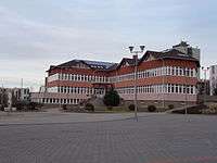 Bátonyterenye, Town Hall
 Gyürky-Solymossy Mansion in Bátonyterenye
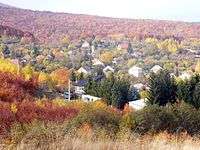 View of Szuha
_(6722._sz%C3%A1m%C3%BA_m%C5%B1eml%C3%A9k)_2.jpg) Our Lady Church in Szentkút (Mátraverebély)
Our Lady Church in Szentkút (Mátraverebély)
See also
References
- ↑ A KSH 2013. évi helységnévkönyve
- ↑ népesség.com, "Bátonyterenyei járás népessége"
- ↑ 4.1.6.1 A népesség nemzetiség szerint, 2011, (in Hungarian)
- ↑ 4.1.7.1 A népesség vallás, felekezet szerint, 2011, (in Hungarian)
External links
| Town (1) |
| |
|---|---|---|
| Villages (7) | ||