Bátonyterenye
| Bátonyterenye | ||
|---|---|---|
| Town | ||
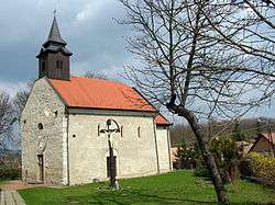 Medieval church of Maconka | ||
| ||
 Bátonyterenye Location of Bátonyterenye | ||
| Coordinates: 47°59′26″N 19°49′51″E / 47.99060°N 19.83091°ECoordinates: 47°59′26″N 19°49′51″E / 47.99060°N 19.83091°E | ||
| Country |
| |
| County | Nógrád | |
| District | Bátonyterenye | |
| Area | ||
| • Total | 80.09 km2 (30.92 sq mi) | |
| Population (2004) | ||
| • Total | 14,240 | |
| • Density | 177.79/km2 (460.5/sq mi) | |
| Time zone | UTC+1 (CET) | |
| • Summer (DST) | UTC+2 (CEST) | |
| Postal code | 3070 | |
| Area code | (+36) 32 | |
| Website |
www | |
Bátonyterenye is a town in Nógrád county, in Northern Hungary.
Bátonyterenye was created in 1984 by the unification of three villages (Nagybátony, Kisterenye, Szúpatak). The new settlement became a city in 1989. Bátonyterenye was a typical socialist mining city.
Twin towns – sister cities
Bátonyterenye is twinned with:
External links
| Wikimedia Commons has media related to Bátonyterenye. |
- Official site in Hungarian and English
- Street map (in Hungarian)
| Town (1) |
| |
|---|---|---|
| Villages (7) | ||

This article is issued from
Wikipedia.
The text is licensed under Creative Commons - Attribution - Sharealike.
Additional terms may apply for the media files.