Hackney, Kansas
| Hackney, Kansas | |
|---|---|
| Unincorporated community | |
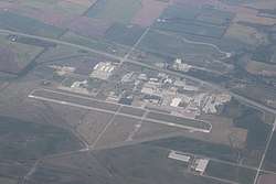 Aerial view of Hackney, including Strother Field industrial park and airport | |
 KDOT map of Cowley County (legend) | |
 Hackney  Hackney | |
| Coordinates: 37°10′27″N 97°1′52″W / 37.17417°N 97.03111°WCoordinates: 37°10′27″N 97°1′52″W / 37.17417°N 97.03111°W | |
| Country | United States |
| State | Kansas |
| County | Cowley |
| Time zone | UTC-6 (CST) |
| • Summer (DST) | UTC-5 (CDT) |
| Area code | 620 |
Hackney is an unincorporated community in Cowley County, Kansas, United States.[1]
History
The town was named after William P. Hackney, a colorful frontier lawyer and politician from Cowley County. Hackney was a station and shipping point on the Atchison, Topeka and Santa Fe Railway.[2] The post office was established March 31, 1894, and discontinued February 15, 1924.[3]
An airport was built in the early 1940s and was used as a training airfield by the United States Army Air Forces during World War II. The airport is now called Strother Field and it is the home of Strother Field Industrial Park.
References
- ↑ U.S. Geological Survey Geographic Names Information System: Hackney, Kansas
- ↑ Blackmar, Frank Wilson (1912). Kansas: A Cyclopedia of State History, Embracing Events, Institutions, Industries, Counties, Cities, Towns, Prominent Persons, Etc. Standard Publishing Company. p. 800.
- ↑ "Kansas Post Offices, 1828-1961 (archived)". Kansas Historical Society. Archived from the original on October 9, 2013. Retrieved 6 June 2014.
Further reading
External links
Municipalities and communities of Cowley County, Kansas, United States | ||
|---|---|---|
| Cities |  | |
| Unincorporated communities | ||
| Townships | ||
| Footnotes | ‡This populated place also has portions in an adjacent county or counties | |
This article is issued from
Wikipedia.
The text is licensed under Creative Commons - Attribution - Sharealike.
Additional terms may apply for the media files.