Arbory
Coordinates: 54°06′29″N 4°41′38″W / 54.108°N 4.694°W
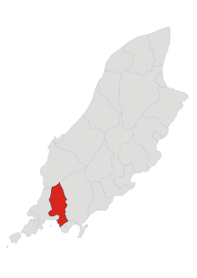
Parish of Arbory
Arbory (Manx:Skeerey Chairbre) is a parish in the Isle of Man. The name is derived from "Kirk Cairbre".[1] It forms part of the sheading of Rushen in the south of the island, and its main settlements are Colby and Ballabeg (where the parish church is located).
Demographics
The Isle of Man census of 2016 returned a parish population of 1,847, an increase of 5.4% from the figure of 1,747 in 2011.[2]
References
External links
- Arbory Parish Commissioners
- Manxnotebook Arbory Detail about Manx parishes and description of Arbory Parish.
- Manxnotebook - Arbory with full description of the parish and photographs
- Arbory Parish Community and Local Government Arbory Commissioners, photographs, local clubs, societies and churches.
- Isle of Man Building Control Districts showing parish boundaries
- Manxnotebook Kirk Arbory Antiquities
- Qualtrough.org Family Genealogy with family details and photographs.
- Glenology - Manx Glens An ongoing study of Manx glens, their locations and meanings.
This article is issued from
Wikipedia.
The text is licensed under Creative Commons - Attribution - Sharealike.
Additional terms may apply for the media files.