Bride (parish)
Coordinates: 54°22′05″N 4°22′41″W / 54.368°N 4.378°W
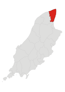
Bride (Manx: Skeerey Vreeshey), named after St Brigid, is a parish in the sheading of Ayre and lies in the extreme north of the Isle of Man. The parish lies to the east of Andreas and to the north of Lezayre, bordering the sea to the north and east. The parish covers an area of about 9 square miles (23 km2) and contains the village of Bride or Kirk Bride.
Demographics
The Isle of Man census of 2016 returned a parish population of 382, a decrease of 5% from the figure of 401 in 2011.[1] This means that Bride is easily the lowest-populated administrative area on the island. The parish has the highest proportion of Manx Gaelic speakers on the island (4.49%), according to the 2011 census.
Topography
There is a range of sandhills crossing the parish from west to Point Cranstal (not actually a point) in the east, from which a good view may be obtained of the Manx mountains as well as of the Scottish and Cumbrian mountains (with the Solway Firth in between). Otherwise the parish is flat and low-lying. The Galloway coast is about 18 miles (29 km) away. At the Point of Ayre is a 100 feet (30 m) lighthouse. On old maps Point Cranstal is named as "Shellag Point" and a hamlet named Cranstal is marked close to it, but this has long since disappeared.
Telegraph cable
The first Isle of Man submarine telegraph cable to the mainland was laid from Cranstal to St Bees on the Cumberland coast in 1859. Due to damage from tidal currents the cable was later moved to Port Cornaa.
References
- Manxnotebook Bride. Details about Bride parish.
- Manxnotebook Kirk Bride Antiquities
- Isle of Man Building Control Districts showing parish boundaries
- Isle of Man Census Report 2006
| Towns |
| ||||||||
|---|---|---|---|---|---|---|---|---|---|
| Villages | |||||||||
| Sheadings | |||||||||
| Parishes | |||||||||
| Transport | |||||||||
| Heraldry | |||||||||
| Education |
| ||||||||