Patrick (parish)
Coordinates: 54°09′07″N 4°40′23″W / 54.152°N 4.673°W
| Parish of Patrick | |
|---|---|
 | |
| Details | |
| Population | 1,576 (Isle of Man census, 2016) |
| Sheading | Glenfaba |
| Largest village | Glen Maye |
| Parish church | Kirk Patrick (Anglican) |
| Industry | Agrarian and Tourism |
| Main peaks | |
| Dalby Mountain, South Barrule | |
| Main glens | |
| Rushen, Dhoo | |
| Treens | |
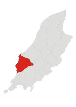
Patrick is an administrative and historic parish in the sheading of Glenfaba, on the west coast of the Isle of Man.
Geography
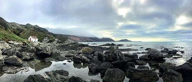
The parish is bounded by Peel in the north, German in the north and east, Marown to the east, Malew to the south-east, Arbory and Rushen to the south, and the Irish Sea to the west. The parish is a mainly hilly area including the northern slopes of the South Barrule; Slieau Whallian; and to the west, Dalby Mountain. Glen Rushen is located between Dalby Mountain and the South Barrule, and leads downwards to Glen Mooar and finally Glen Maye. Through these glens flows the Glenmaye river, with the Glenmaye waterfall, about one mile from the coast. There are disused slate quarries in Glen Rushen. In common with other hilly areas of the island, there are several forest plantations.
The coastal strip, roughly that to the west of the A27 road, is flatter agricultural land.
The population was historically partly agricultural, fishing, and mining. Now it is sparsely distributed over the parish: there are four small villages, Dalby near the coast on the west side of Dalby Mountain, Foxdale, a former mining village, Patrick in the north, and Glen Maye, near the coast and home to the glen of the same name.[1] The parish also includes the southern part of the village of St John's.
The parish forms part of the ecclesiastical (Anglican) Parish of the West Coast.
Demographics
The Isle of Man census of 2016 returned a parish population of 1,576, an increase of 3.1% from the figure of 1,527 in 2011.[2]
References
- ↑ "Parish of Patrick". isleofman.com. 2006. Retrieved 2008-10-05.
- ↑ 2016 Isle of Man Census Report