Apatzingán
| Apatzingán | ||
|---|---|---|
| City | ||
| Apatzingán de la Constitución | ||
| ||
| Nickname(s): La Perla de Tierra Caliente, Cuna de la Constitución Mexicana | ||
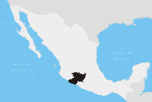
 Apatzingán Location of Apatzingán in Mexico Apatzingán Apatzingán (Mexico) | ||
| Coordinates: 19°05′19″N 102°21′03″W / 19.08861°N 102.35083°WCoordinates: 19°05′19″N 102°21′03″W / 19.08861°N 102.35083°W | ||
| Country | Mexico | |
| State | Michoacán | |
| Municipality | Apatzingán | |
| Founded | 1617 | |
| Government | ||
| • Municipal President | Uriel Chávez Mendoza (PRI) | |
| Elevation | 325 m (1,066 ft) | |
| Population (2010)[1] | ||
| • Total | 99,010 | |
| Time zone | UTC-6 (CST) | |
| • Summer (DST) | UTC-5 (CDT) | |
| Area code(s) | 453 | |
| Website | Official Website | |

Apatzingán (in full, Apatzingán de la Constitución) is a city and its surrounding municipality, in the west-central region of the Mexican state of Michoacán.
Geography
The Municipality of Apatzingán is located in the Tierra Caliente Valley. It has an area of 1,656.67 km² (639.64 sq mi), and reported a population of 99,010 (2010).
The city of Apatzingán is the fourth-largest in Michoacán (behind Morelia, Uruapan, and Zamora), with a 2005 census population of 93,180 persons.
The major Sierra Madre del Sur mountain range and the municipality of Coalcomán de Vázquez Pallares are to the west.
History
Mexico's Constitution of Apatzingán was signed in the city in 1814, during the Mexican War of Independence in the Viceroyalty of New Spain against the Spanish Empire.
Climate
Despite having an annual precipitation of 752 millimetres (29.6 in), Apatzingán has a semi-arid climate (Köppen climate classification Bsh) due to its hot temperatures and high evaporation rates.[2]
| Climate data for Apatzingán | |||||||||||||
|---|---|---|---|---|---|---|---|---|---|---|---|---|---|
| Month | Jan | Feb | Mar | Apr | May | Jun | Jul | Aug | Sep | Oct | Nov | Dec | Year |
| Record high °C (°F) | 38.0 (100.4) |
39.0 (102.2) |
42.0 (107.6) |
43.0 (109.4) |
46.5 (115.7) |
44.0 (111.2) |
43.0 (109.4) |
39.5 (103.1) |
39.0 (102.2) |
41.5 (106.7) |
43.0 (109.4) |
37.0 (98.6) |
46.5 (115.7) |
| Average high °C (°F) | 32.3 (90.1) |
33.8 (92.8) |
36.4 (97.5) |
39.0 (102.2) |
40.0 (104) |
37.8 (100) |
34.7 (94.5) |
34.1 (93.4) |
33.7 (92.7) |
34.1 (93.4) |
34.0 (93.2) |
32.9 (91.2) |
35.2 (95.4) |
| Daily mean °C (°F) | 24.7 (76.5) |
26.0 (78.8) |
28.4 (83.1) |
30.7 (87.3) |
32.7 (90.9) |
31.6 (88.9) |
29.2 (84.6) |
28.5 (83.3) |
28.2 (82.8) |
28.2 (82.8) |
27.3 (81.1) |
25.7 (78.3) |
28.4 (83.1) |
| Average low °C (°F) | 17.1 (62.8) |
18.1 (64.6) |
20.3 (68.5) |
22.4 (72.3) |
25.4 (77.7) |
25.5 (77.9) |
23.6 (74.5) |
22.9 (73.2) |
22.7 (72.9) |
22.2 (72) |
20.7 (69.3) |
18.5 (65.3) |
21.6 (70.9) |
| Record low °C (°F) | 8.5 (47.3) |
10.0 (50) |
13.0 (55.4) |
13.0 (55.4) |
17.5 (63.5) |
15.0 (59) |
17.0 (62.6) |
18.5 (65.3) |
19.0 (66.2) |
14.0 (57.2) |
11.0 (51.8) |
10.0 (50) |
8.5 (47.3) |
| Average precipitation mm (inches) | 17.1 (0.673) |
1.1 (0.043) |
0.8 (0.031) |
0.6 (0.024) |
11.2 (0.441) |
129.5 (5.098) |
166.2 (6.543) |
175.2 (6.898) |
148.5 (5.846) |
81.9 (3.224) |
14.6 (0.575) |
5.2 (0.205) |
751.9 (29.602) |
| Average precipitation days (≥ 0.1 mm) | 1.3 | 0.4 | 0.3 | 0.2 | 1.6 | 11.4 | 14.6 | 14.3 | 12.3 | 5.6 | 1.5 | 0.6 | 64.1 |
| Source: Servicio Meteorologico Nacional[3] | |||||||||||||
See also
References
- ↑ "Principales resultados por localidad 2010 (ITER)". Instituto Nacional de Estadística y Geografía. 2010.
- ↑ Kottek, M.; J. Grieser; C. Beck; B. Rudolf; F. Rubel (2006). "World Map of the Köppen-Geiger climate classification updated" (PDF). Meteorol. Z. 15 (3): 259–263. doi:10.1127/0941-2948/2006/0130. Retrieved 28 August 2012.
- ↑ NORMALES CLIMATOLÓGICAS 1971-2000 (in Spanish). National Meteorological Service of Mexico. Retrieved August 28, 2012.
Sources
- Link to tables of population data from Census of 2005 Instituto Nacional de Estadística, Geografía e Informática (INEGI)
- Michoacán Enciclopedia de los Municipios de México
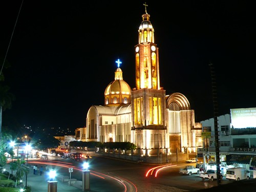
- " Photograph from Apatzingan's main church
External links
- Ayuntamiento de Apatzingán Official website
- Apatzingan Map