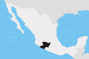
Charo Municipality
Charo is a municipality located in the Mexican state of Michoacán. The municipality has an area of 322.50 square kilometres (0.29% of the surface of the state) and is bordered to the north by Tarímbaro and Álvaro Obregón, to the east by Indaparapeo, to the south by Tzitzío, and to the west and southwest by Morelia. The municipality had a population of 19,417 inhabitants according to the 2005 census.[1] Its municipal seat is the city of the same name.
The economy of the municipality is mostly based on ranching and agriculture, with maize, carrots and beans the main crops.
In pre-Hispanic times the area was inhabited by the Matlaltzingas, who were allies of the Purépecha, the dominant force in the region at the time.
References
- ↑ {{Cite web is a municipality situated in Michoacán, Mexico. Founded in 1455, by the piririndas, it was later elevated to township in 1845 by president Guadalupe Victoria. |url=http://www.inegi.gob.mx/est/contenidos/espanol/sistemas/conteo2005/localidad/iter/ |title=2005 Census |work=INEGI: Instituto Nacional de Estadística, Geografía e Informática |accessdate=2007-09-19 |deadurl=yes |archiveurl=https://www.webcitation.org/6EjXaEdST?url=http://www.inegi.gob.mx/est/contenidos/espanol/sistemas/conteo2005/localidad/iter/ |archivedate=2013-02-27 |df= }}
Coordinates: 19°45′N 101°03′W / 19.750°N 101.050°W